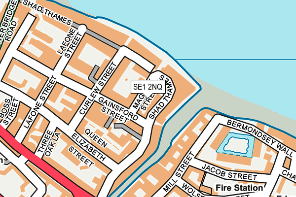
SE1 2NQ lies on Maguire Street in London. SE1 2NQ is located in the North Bermondsey electoral ward, within the London borough of Southwark and the English Parliamentary constituency of Bermondsey and Old Southwark. The Sub Integrated Care Board (ICB) Location is NHS South East London ICB - 72Q and the police force is Metropolitan Police. This postcode has been in use since January 1980.


GetTheData
Source: OS OpenMap – Local (Ordnance Survey)
Source: OS VectorMap District (Ordnance Survey)
Licence: Open Government Licence (requires attribution)
| Easting | 533887 |
| Northing | 179920 |
| Latitude | 51.502365 |
| Longitude | -0.072414 |
GetTheData
Source: Open Postcode Geo
Licence: Open Government Licence
| Street | Maguire Street |
| Town/City | London |
| Country | England |
| Postcode District | SE1 |
➜ See where SE1 is on a map ➜ Where is Bermondsey? | |
GetTheData
Source: Land Registry Price Paid Data
Licence: Open Government Licence
Elevation or altitude of SE1 2NQ as distance above sea level:
| Metres | Feet | |
|---|---|---|
| Elevation | 10m | 33ft |
Elevation is measured from the approximate centre of the postcode, to the nearest point on an OS contour line from OS Terrain 50, which has contour spacing of ten vertical metres.
➜ How high above sea level am I? Find the elevation of your current position using your device's GPS.
GetTheData
Source: Open Postcode Elevation
Licence: Open Government Licence
| Ward | North Bermondsey |
| Constituency | Bermondsey And Old Southwark |
GetTheData
Source: ONS Postcode Database
Licence: Open Government Licence
| Tanner Street (Tooley Street) | Bermondsey | 242m |
| Dockhead | Bermondsey | 264m |
| Tanner Street | Bermondsey | 273m |
| Boss Street (Tooley Street) | Bermondsey | 285m |
| Dockhead (Jamaica Road) | Bermondsey | 292m |
| Bermondsey Underground Station | Bermondsey | 775m |
| Tower Hill Underground Station | Tower Hill | 893m |
| Tower Gateway Dlr Station (Minories) | Tower Gateway | 933m |
| London Bridge Underground Station | London Bridge | 1,202m |
| Monument Underground Station | Monument | 1,321m |
| London Bridge Station | 1km |
| London Fenchurch Street Station | 1.1km |
| Wapping Station | 1.2km |
GetTheData
Source: NaPTAN
Licence: Open Government Licence
GetTheData
Source: ONS Postcode Database
Licence: Open Government Licence


➜ Get more ratings from the Food Standards Agency
GetTheData
Source: Food Standards Agency
Licence: FSA terms & conditions
| Last Collection | |||
|---|---|---|---|
| Location | Mon-Fri | Sat | Distance |
| Gainsford Street | 18:30 | 13:00 | 180m |
| 35 Dockhead | 18:30 | 13:00 | 233m |
| Tooley Street | 18:30 | 236m | |
GetTheData
Source: Dracos
Licence: Creative Commons Attribution-ShareAlike
| Risk of SE1 2NQ flooding from rivers and sea | Very Low |
| ➜ SE1 2NQ flood map | |
GetTheData
Source: Open Flood Risk by Postcode
Licence: Open Government Licence
The below table lists the International Territorial Level (ITL) codes (formerly Nomenclature of Territorial Units for Statistics (NUTS) codes) and Local Administrative Units (LAU) codes for SE1 2NQ:
| ITL 1 Code | Name |
|---|---|
| TLI | London |
| ITL 2 Code | Name |
| TLI4 | Inner London - East |
| ITL 3 Code | Name |
| TLI44 | Lewisham and Southwark |
| LAU 1 Code | Name |
| E09000028 | Southwark |
GetTheData
Source: ONS Postcode Directory
Licence: Open Government Licence
The below table lists the Census Output Area (OA), Lower Layer Super Output Area (LSOA), and Middle Layer Super Output Area (MSOA) for SE1 2NQ:
| Code | Name | |
|---|---|---|
| OA | E00167477 | |
| LSOA | E01032637 | Southwark 003F |
| MSOA | E02000809 | Southwark 003 |
GetTheData
Source: ONS Postcode Directory
Licence: Open Government Licence
| SE1 2PB | Shad Thames | 35m |
| SE1 2PG | Gainsford Street | 35m |
| SE1 2YJ | Shad Thames | 47m |
| SE1 2PY | Butlers & Colonial Wharf | 58m |
| SE1 2YW | Shad Thames | 59m |
| SE1 2YQ | Shad Thames | 67m |
| SE1 2AS | Shad Thames | 72m |
| SE1 2YH | Shad Thames | 80m |
| SE1 2ND | Curlew Street | 82m |
| SE1 2NE | Gainsford Street | 82m |
GetTheData
Source: Open Postcode Geo; Land Registry Price Paid Data
Licence: Open Government Licence