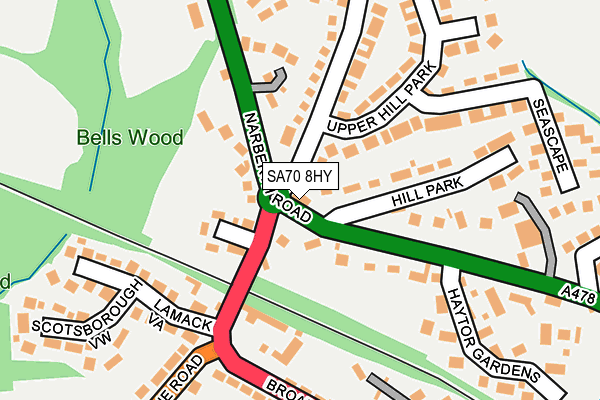
SA70 8HY lies on Narberth Road in Tenby. SA70 8HY is located in the Tenby: North electoral ward, within the unitary authority of Pembrokeshire and the Welsh Parliamentary constituency of Carmarthen West and South Pembrokeshire. The Local Health Board is Hywel Dda University and the police force is Dyfed-Powys. This postcode has been in use since January 1980.


GetTheData
Source: OS OpenMap – Local (Ordnance Survey)
Source: OS VectorMap District (Ordnance Survey)
Licence: Open Government Licence (requires attribution)
| Easting | 212556 |
| Northing | 201261 |
| Latitude | 51.678752 |
| Longitude | -4.712598 |
GetTheData
Source: Open Postcode Geo
Licence: Open Government Licence
| Street | Narberth Road |
| Town/City | Tenby |
| Country | Wales |
| Postcode District | SA70 |
| ➜ SA70 open data dashboard ➜ See where SA70 is on a map ➜ Where is Tenby? | |
GetTheData
Source: Land Registry Price Paid Data
Licence: Open Government Licence
Elevation or altitude of SA70 8HY as distance above sea level:
| Metres | Feet | |
|---|---|---|
| Elevation | 50m | 164ft |
Elevation is measured from the approximate centre of the postcode, to the nearest point on an OS contour line from OS Terrain 50, which has contour spacing of ten vertical metres.
➜ How high above sea level am I? Find the elevation of your current position using your device's GPS.
GetTheData
Source: Open Postcode Elevation
Licence: Open Government Licence
| Ward | Tenby: North |
| Constituency | Carmarthen West And South Pembrokeshire |
GetTheData
Source: ONS Postcode Database
Licence: Open Government Licence
| January 2023 | Anti-social behaviour | On or near Slippery Back | 433m |
| August 2022 | Criminal damage and arson | On or near Slippery Back | 433m |
| June 2022 | Criminal damage and arson | On or near Seascape | 259m |
| ➜ Narberth Road crime map and outcomes | |||
GetTheData
Source: data.police.uk
Licence: Open Government Licence
| Cambrian Cottages (Lady Park) | Tenby | 41m |
| Serpentine Road (A478 Serpentine Road ) | Tenby | 47m |
| White Oaks (Narberth Road) | Tenby | 60m |
| Upper Hill Park | Tenby | 198m |
| Serpentine Road North (Serpentine Road) | Tenby | 243m |
| Tenby Station | 0.8km |
| Penally Station | 2.3km |
| Saundersfoot Station | 4.8km |
GetTheData
Source: NaPTAN
Licence: Open Government Licence
| Percentage of properties with Next Generation Access | 100.0% |
| Percentage of properties with Superfast Broadband | 100.0% |
| Percentage of properties with Ultrafast Broadband | 0.0% |
| Percentage of properties with Full Fibre Broadband | 0.0% |
Superfast Broadband is between 30Mbps and 300Mbps
Ultrafast Broadband is > 300Mbps
| Percentage of properties unable to receive 2Mbps | 0.0% |
| Percentage of properties unable to receive 5Mbps | 0.0% |
| Percentage of properties unable to receive 10Mbps | 0.0% |
| Percentage of properties unable to receive 30Mbps | 0.0% |
GetTheData
Source: Ofcom
Licence: Ofcom Terms of Use (requires attribution)
GetTheData
Source: ONS Postcode Database
Licence: Open Government Licence


➜ Get more ratings from the Food Standards Agency
GetTheData
Source: Food Standards Agency
Licence: FSA terms & conditions
| Last Collection | |||
|---|---|---|---|
| Location | Mon-Fri | Sat | Distance |
| Flemish Chimney | 17:00 | 09:45 | 846m |
| The Croft | 17:15 | 12:00 | 898m |
| Tenby Delivery Office | 18:00 | 12:30 | 949m |
GetTheData
Source: Dracos
Licence: Creative Commons Attribution-ShareAlike
| School | Phase of Education | Distance |
|---|---|---|
| The Greenhill School Heywood Lane, Tenby, Pembrokeshire, SA70 8BN | Not applicable | 630m |
| St Teilos V.R.C. School Greenhill Road, Tenby, Pembrokeshire, SA70 7LJ | Not applicable | 746m |
| Saundersfoot C.P. School Francis Lane, Saundersfoot, Pembrokeshire, SA69 9HB | Not applicable | 4km |
GetTheData
Source: Edubase
Licence: Open Government Licence
The below table lists the International Territorial Level (ITL) codes (formerly Nomenclature of Territorial Units for Statistics (NUTS) codes) and Local Administrative Units (LAU) codes for SA70 8HY:
| ITL 1 Code | Name |
|---|---|
| TLL | Wales |
| ITL 2 Code | Name |
| TLL1 | West Wales and The Valleys |
| ITL 3 Code | Name |
| TLL14 | South West Wales |
| LAU 1 Code | Name |
| W06000009 | Pembrokeshire |
GetTheData
Source: ONS Postcode Directory
Licence: Open Government Licence
The below table lists the Census Output Area (OA), Lower Layer Super Output Area (LSOA), and Middle Layer Super Output Area (MSOA) for SA70 8HY:
| Code | Name | |
|---|---|---|
| OA | W00003331 | |
| LSOA | W01000619 | Pembrokeshire 016B |
| MSOA | W02000141 | Pembrokeshire 016 |
GetTheData
Source: ONS Postcode Directory
Licence: Open Government Licence
| SA70 8JB | Glenview Crescent | 81m |
| SA70 8JD | Narberth Road | 106m |
| SA70 8HX | Hill Park | 129m |
| SA70 8JE | Upper Hill Park | 138m |
| SA70 8DN | Lamack Vale | 174m |
| SA70 8DQ | Broadwell Hayes | 189m |
| SA70 8JF | Upper Hill Park | 195m |
| SA70 8JH | Lady Park | 217m |
| SA70 8DH | Jubilee Cottages | 227m |
| SA70 8HT | Narberth Road | 227m |
GetTheData
Source: Open Postcode Geo; Land Registry Price Paid Data
Licence: Open Government Licence