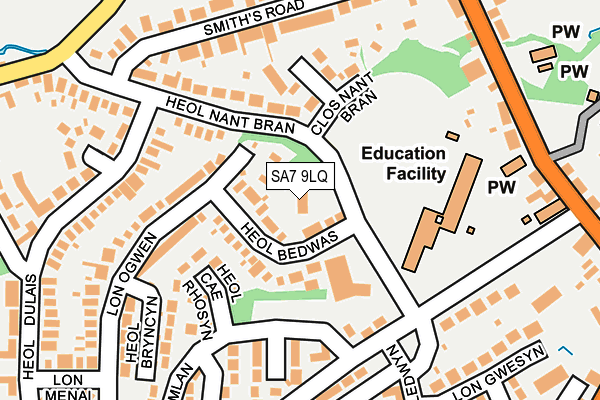
SA7 9LQ is in Birchgrove, Swansea. SA7 9LQ is located in the Llansamlet electoral ward, within the unitary authority of Swansea and the Welsh Parliamentary constituency of Swansea East. The Local Health Board is Swansea Bay University and the police force is South Wales. This postcode has been in use since January 1980.


GetTheData
Source: OS OpenMap – Local (Ordnance Survey)
Source: OS VectorMap District (Ordnance Survey)
Licence: Open Government Licence (requires attribution)
| Easting | 270310 |
| Northing | 198456 |
| Latitude | 51.669870 |
| Longitude | -3.876806 |
GetTheData
Source: Open Postcode Geo
Licence: Open Government Licence
| Locality | Birchgrove |
| Town/City | Swansea |
| Country | Wales |
| Postcode District | SA7 |
| ➜ SA7 open data dashboard ➜ See where SA7 is on a map ➜ Where is Swansea? | |
GetTheData
Source: Land Registry Price Paid Data
Licence: Open Government Licence
Elevation or altitude of SA7 9LQ as distance above sea level:
| Metres | Feet | |
|---|---|---|
| Elevation | 60m | 197ft |
Elevation is measured from the approximate centre of the postcode, to the nearest point on an OS contour line from OS Terrain 50, which has contour spacing of ten vertical metres.
➜ How high above sea level am I? Find the elevation of your current position using your device's GPS.
GetTheData
Source: Open Postcode Elevation
Licence: Open Government Licence
| Ward | Llansamlet |
| Constituency | Swansea East |
GetTheData
Source: ONS Postcode Database
Licence: Open Government Licence
| October 2023 | Other theft | On or near Heol Camlan | 182m |
| October 2023 | Criminal damage and arson | On or near Heol Camlan | 182m |
| August 2023 | Criminal damage and arson | On or near Heol-Las | 491m |
| ➜ Get more crime data in our Crime section | |||
GetTheData
Source: data.police.uk
Licence: Open Government Licence
| School (Heol Dulais) | Birchgrove | 166m |
| School (Heol Dulais) | Birchgrove | 170m |
| Smiths Road (Heol Nant Bran) | Birchgrove | 220m |
| Smiths Road (Heol Nant Bran) | Birchgrove | 253m |
| Comprehensive School (Grounds) | Birchgrove | 272m |
| Llansamlet Station | 1.1km |
| Skewen Station | 2.3km |
| Neath Station | 4.9km |
GetTheData
Source: NaPTAN
Licence: Open Government Licence
| Percentage of properties with Next Generation Access | 100.0% |
| Percentage of properties with Superfast Broadband | 100.0% |
| Percentage of properties with Ultrafast Broadband | 0.0% |
| Percentage of properties with Full Fibre Broadband | 0.0% |
Superfast Broadband is between 30Mbps and 300Mbps
Ultrafast Broadband is > 300Mbps
| Percentage of properties unable to receive 2Mbps | 0.0% |
| Percentage of properties unable to receive 5Mbps | 0.0% |
| Percentage of properties unable to receive 10Mbps | 0.0% |
| Percentage of properties unable to receive 30Mbps | 0.0% |
GetTheData
Source: Ofcom
Licence: Ofcom Terms of Use (requires attribution)
GetTheData
Source: ONS Postcode Database
Licence: Open Government Licence


➜ Get more ratings from the Food Standards Agency
GetTheData
Source: Food Standards Agency
Licence: FSA terms & conditions
| Last Collection | |||
|---|---|---|---|
| Location | Mon-Fri | Sat | Distance |
| Heron Drive | 18:30 | 1,216m | |
| Herbert Thomas Way | 17:00 | 12:30 | 1,225m |
| Glais P O | 17:15 | 11:45 | 2,054m |
GetTheData
Source: Dracos
Licence: Creative Commons Attribution-ShareAlike
| School | Phase of Education | Distance |
|---|---|---|
| Birchgrove Primary Heol Nant Bran, Bircgrove, Swansea, SA7 9LS | Not applicable | 154m |
| Birchgrove Comprehensive School Birchgrove Road, Birchgrove, Swansea, SA7 9NB | Not applicable | 367m |
| Talycopa Primary School Heol Hafdy, Llansamlet, Swansea, SA7 9RZ | Not applicable | 1.5km |
GetTheData
Source: Edubase
Licence: Open Government Licence
The below table lists the International Territorial Level (ITL) codes (formerly Nomenclature of Territorial Units for Statistics (NUTS) codes) and Local Administrative Units (LAU) codes for SA7 9LQ:
| ITL 1 Code | Name |
|---|---|
| TLL | Wales |
| ITL 2 Code | Name |
| TLL1 | West Wales and The Valleys |
| ITL 3 Code | Name |
| TLL18 | Swansea |
| LAU 1 Code | Name |
| W06000011 | Swansea |
GetTheData
Source: ONS Postcode Directory
Licence: Open Government Licence
The below table lists the Census Output Area (OA), Lower Layer Super Output Area (LSOA), and Middle Layer Super Output Area (MSOA) for SA7 9LQ:
| Code | Name | |
|---|---|---|
| OA | W00004262 | |
| LSOA | W01000796 | Swansea 006B |
| MSOA | W02000173 | Swansea 006 |
GetTheData
Source: ONS Postcode Directory
Licence: Open Government Licence
| SA7 9LF | Heol Bedwas | 39m |
| SA7 9LY | Heol Cae Rhosyn | 106m |
| SA7 9LS | Heol Nant Bran | 123m |
| SA7 9JY | Clos Nant Bran | 133m |
| SA7 9LR | Lon Ogwen | 179m |
| SA7 9LL | Heol Camlan | 193m |
| SA7 9LH | Heol Dulais | 201m |
| SA7 9LX | Heol Dulais | 205m |
| SA7 9DY | Smiths Road | 208m |
| SA7 9LJ | Heol Camlan | 214m |
GetTheData
Source: Open Postcode Geo; Land Registry Price Paid Data
Licence: Open Government Licence