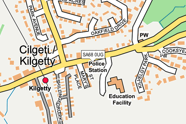
SA68 0UG lies on Carmarthen Road in Kilgetty. SA68 0UG is located in the Kilgetty and Begelly electoral ward, within the unitary authority of Pembrokeshire and the Welsh Parliamentary constituency of Carmarthen West and South Pembrokeshire. The Local Health Board is Hywel Dda University and the police force is Dyfed-Powys. This postcode has been in use since January 1980.


GetTheData
Source: OS OpenMap – Local (Ordnance Survey)
Source: OS VectorMap District (Ordnance Survey)
Licence: Open Government Licence (requires attribution)
| Easting | 212789 |
| Northing | 207305 |
| Latitude | 51.733111 |
| Longitude | -4.712478 |
GetTheData
Source: Open Postcode Geo
Licence: Open Government Licence
| Street | Carmarthen Road |
| Town/City | Kilgetty |
| Country | Wales |
| Postcode District | SA68 |
| ➜ SA68 open data dashboard ➜ See where SA68 is on a map ➜ Where is Kilgetty? | |
GetTheData
Source: Land Registry Price Paid Data
Licence: Open Government Licence
Elevation or altitude of SA68 0UG as distance above sea level:
| Metres | Feet | |
|---|---|---|
| Elevation | 80m | 262ft |
Elevation is measured from the approximate centre of the postcode, to the nearest point on an OS contour line from OS Terrain 50, which has contour spacing of ten vertical metres.
➜ How high above sea level am I? Find the elevation of your current position using your device's GPS.
GetTheData
Source: Open Postcode Elevation
Licence: Open Government Licence
| Ward | Kilgetty And Begelly |
| Constituency | Carmarthen West And South Pembrokeshire |
GetTheData
Source: ONS Postcode Database
Licence: Open Government Licence
ESPERANZA, CARMARTHEN ROAD, KILGETTY, SA68 0UG 1998 14 AUG £47,000 |
GetTheData
Source: HM Land Registry Price Paid Data
Licence: Contains HM Land Registry data © Crown copyright and database right 2024. This data is licensed under the Open Government Licence v3.0.
| November 2022 | Criminal damage and arson | On or near Cooksyeat View | 274m |
| August 2022 | Violence and sexual offences | On or near Kilvelgy Park | 231m |
| June 2022 | Criminal damage and arson | On or near Sports/Recreation Area | 277m |
| ➜ Get more crime data in our Crime section | |||
GetTheData
Source: data.police.uk
Licence: Open Government Licence
| St Mary's Place (Main Road) | Kilgetty | 60m |
| Stepaside School (Main Road) | Kilgetty | 75m |
| Ryelands Lane | Kilgetty | 338m |
| Co-op (Carmarthen Road) | Kilgetty | 350m |
| Community Centre (Main Road) | Kilgetty | 570m |
| Kilgetty Station | 0.2km |
| Saundersfoot Station | 1.3km |
GetTheData
Source: NaPTAN
Licence: Open Government Licence
| Percentage of properties with Next Generation Access | 100.0% |
| Percentage of properties with Superfast Broadband | 100.0% |
| Percentage of properties with Ultrafast Broadband | 0.0% |
| Percentage of properties with Full Fibre Broadband | 0.0% |
Superfast Broadband is between 30Mbps and 300Mbps
Ultrafast Broadband is > 300Mbps
| Percentage of properties unable to receive 2Mbps | 0.0% |
| Percentage of properties unable to receive 5Mbps | 0.0% |
| Percentage of properties unable to receive 10Mbps | 0.0% |
| Percentage of properties unable to receive 30Mbps | 0.0% |
GetTheData
Source: Ofcom
Licence: Ofcom Terms of Use (requires attribution)
GetTheData
Source: ONS Postcode Database
Licence: Open Government Licence


➜ Get more ratings from the Food Standards Agency
GetTheData
Source: Food Standards Agency
Licence: FSA terms & conditions
| Last Collection | |||
|---|---|---|---|
| Location | Mon-Fri | Sat | Distance |
| Summerhill Stores | 15:30 | 08:00 | 2,491m |
| Kilanow | 15:00 | 09:30 | 2,497m |
| Longstone Cross | 15:00 | 09:00 | 2,959m |
GetTheData
Source: Dracos
Licence: Creative Commons Attribution-ShareAlike
| School | Phase of Education | Distance |
|---|---|---|
| Stepaside C.P. School Carmarthen Road, Kilgetty, Pembrokeshire, SA68 0UG | Not applicable | 97m |
| Saundersfoot C.P. School Francis Lane, Saundersfoot, Pembrokeshire, SA69 9HB | Not applicable | 2.3km |
| Templeton C.P. School School Road, Templeton, Narberth, Pembrokeshire, SA67 8RS | Not applicable | 5km |
GetTheData
Source: Edubase
Licence: Open Government Licence
The below table lists the International Territorial Level (ITL) codes (formerly Nomenclature of Territorial Units for Statistics (NUTS) codes) and Local Administrative Units (LAU) codes for SA68 0UG:
| ITL 1 Code | Name |
|---|---|
| TLL | Wales |
| ITL 2 Code | Name |
| TLL1 | West Wales and The Valleys |
| ITL 3 Code | Name |
| TLL14 | South West Wales |
| LAU 1 Code | Name |
| W06000009 | Pembrokeshire |
GetTheData
Source: ONS Postcode Directory
Licence: Open Government Licence
The below table lists the Census Output Area (OA), Lower Layer Super Output Area (LSOA), and Middle Layer Super Output Area (MSOA) for SA68 0UG:
| Code | Name | |
|---|---|---|
| OA | W00003085 | |
| LSOA | W01000576 | Pembrokeshire 011D |
| MSOA | W02000136 | Pembrokeshire 011 |
GetTheData
Source: ONS Postcode Directory
Licence: Open Government Licence
| SA68 0UJ | Carmarthen Road | 58m |
| SA68 0UH | St Marys Place | 73m |
| SA68 0UQ | Oakfield Drive | 110m |
| SA68 0UP | Ryelands Lane | 128m |
| SA68 0TW | Heritage Gardens | 149m |
| SA68 0UD | Oakfield Drive | 171m |
| SA68 0UW | Mayfield Acres | 200m |
| SA68 0TZ | Kilvelgy Park | 211m |
| SA68 0UB | Park Avenue | 224m |
| SA68 0XR | Station Road | 235m |
GetTheData
Source: Open Postcode Geo; Land Registry Price Paid Data
Licence: Open Government Licence