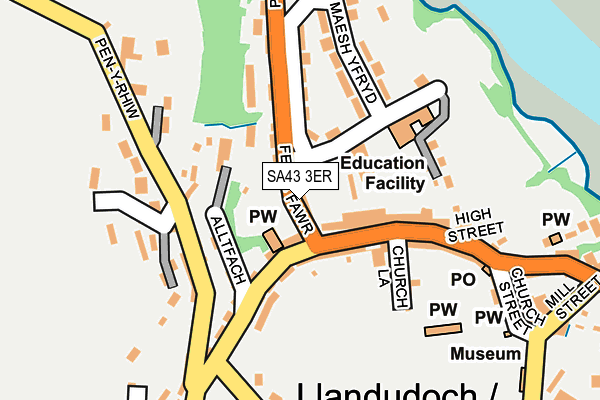
SA43 3ER lies on Grove Terrace in St Dogmaels, Cardigan. SA43 3ER is located in the St Dogmaels electoral ward, within the unitary authority of Pembrokeshire and the Welsh Parliamentary constituency of Preseli Pembrokeshire. The Local Health Board is Hywel Dda University and the police force is Dyfed-Powys. This postcode has been in use since May 1994.


GetTheData
Source: OS OpenMap – Local (Ordnance Survey)
Source: OS VectorMap District (Ordnance Survey)
Licence: Open Government Licence (requires attribution)
| Easting | 216267 |
| Northing | 246040 |
| Latitude | 52.082157 |
| Longitude | -4.682859 |
GetTheData
Source: Open Postcode Geo
Licence: Open Government Licence
| Street | Grove Terrace |
| Locality | St Dogmaels |
| Town/City | Cardigan |
| Country | Wales |
| Postcode District | SA43 |
| ➜ SA43 open data dashboard ➜ See where SA43 is on a map ➜ Where is St Dogmaels? | |
GetTheData
Source: Land Registry Price Paid Data
Licence: Open Government Licence
Elevation or altitude of SA43 3ER as distance above sea level:
| Metres | Feet | |
|---|---|---|
| Elevation | 30m | 98ft |
Elevation is measured from the approximate centre of the postcode, to the nearest point on an OS contour line from OS Terrain 50, which has contour spacing of ten vertical metres.
➜ How high above sea level am I? Find the elevation of your current position using your device's GPS.
GetTheData
Source: Open Postcode Elevation
Licence: Open Government Licence
| Ward | St Dogmaels |
| Constituency | Preseli Pembrokeshire |
GetTheData
Source: ONS Postcode Database
Licence: Open Government Licence
| November 2023 | Violence and sexual offences | On or near Finch Street | 220m |
| October 2023 | Violence and sexual offences | On or near Finch Street | 220m |
| October 2023 | Anti-social behaviour | On or near Finch Street | 220m |
| ➜ Get more crime data in our Crime section | |||
GetTheData
Source: data.police.uk
Licence: Open Government Licence
| Parc Noi (Feidt Mawr) | St Dogmaels | 120m |
| Feidr Fawr (Feidr Mawr) | St Dogmaels | 121m |
| Post Office (High Street) | St Dogmaels | 189m |
| Post Office (High Street) | St Dogmaels | 192m |
| David Street (St. Dogmaels Road) | St Dogmaels | 336m |
GetTheData
Source: NaPTAN
Licence: Open Government Licence
| Percentage of properties with Next Generation Access | 100.0% |
| Percentage of properties with Superfast Broadband | 100.0% |
| Percentage of properties with Ultrafast Broadband | 0.0% |
| Percentage of properties with Full Fibre Broadband | 0.0% |
Superfast Broadband is between 30Mbps and 300Mbps
Ultrafast Broadband is > 300Mbps
| Percentage of properties unable to receive 2Mbps | 0.0% |
| Percentage of properties unable to receive 5Mbps | 0.0% |
| Percentage of properties unable to receive 10Mbps | 0.0% |
| Percentage of properties unable to receive 30Mbps | 0.0% |
GetTheData
Source: Ofcom
Licence: Ofcom Terms of Use (requires attribution)
Estimated total energy consumption in SA43 3ER by fuel type, 2015.
| Consumption (kWh) | 33,645 |
|---|---|
| Meter count | 6 |
| Mean (kWh/meter) | 5,608 |
| Median (kWh/meter) | 3,999 |
GetTheData
Source: Postcode level gas estimates: 2015 (experimental)
Source: Postcode level electricity estimates: 2015 (experimental)
Licence: Open Government Licence
GetTheData
Source: ONS Postcode Database
Licence: Open Government Licence


➜ Get more ratings from the Food Standards Agency
GetTheData
Source: Food Standards Agency
Licence: FSA terms & conditions
| Last Collection | |||
|---|---|---|---|
| Location | Mon-Fri | Sat | Distance |
| Cardigan P O | 17:00 | 12:15 | 1,549m |
| Castle Street | 16:30 | 12:30 | 1,579m |
| Cardigan Delivery Office | 17:15 | 13:00 | 1,628m |
GetTheData
Source: Dracos
Licence: Creative Commons Attribution-ShareAlike
| School | Phase of Education | Distance |
|---|---|---|
| St Dogmaels St Dogmael's, Cardigan, Pembrokeshire, SA43 3ET | Not applicable | 144m |
| Ysgol Uwchradd Aberteifi Park Place, Aberteifi, Ceredigion, SA43 1AD | Not applicable | 1.9km |
| Cilgerran V.C.P. School Cilgerran, Cardigan, Pembrokeshire, SA43 2SB | Not applicable | 4.4km |
GetTheData
Source: Edubase
Licence: Open Government Licence
The below table lists the International Territorial Level (ITL) codes (formerly Nomenclature of Territorial Units for Statistics (NUTS) codes) and Local Administrative Units (LAU) codes for SA43 3ER:
| ITL 1 Code | Name |
|---|---|
| TLL | Wales |
| ITL 2 Code | Name |
| TLL1 | West Wales and The Valleys |
| ITL 3 Code | Name |
| TLL14 | South West Wales |
| LAU 1 Code | Name |
| W06000009 | Pembrokeshire |
GetTheData
Source: ONS Postcode Directory
Licence: Open Government Licence
The below table lists the Census Output Area (OA), Lower Layer Super Output Area (LSOA), and Middle Layer Super Output Area (MSOA) for SA43 3ER:
| Code | Name | |
|---|---|---|
| OA | W00003294 | |
| LSOA | W01000613 | Pembrokeshire 001E |
| MSOA | W02000126 | Pembrokeshire 001 |
GetTheData
Source: ONS Postcode Directory
Licence: Open Government Licence
| SA43 3EP | Feidrfawr | 19m |
| SA43 3EQ | High Street | 46m |
| SA43 3EJ | High Street | 59m |
| SA43 3EX | Brynhyfryd | 81m |
| SA43 3HA | Alltfach | 97m |
| SA43 3EN | Baptist Street | 115m |
| SA43 3EF | High Street | 116m |
| SA43 3EU | Feidrfawr | 117m |
| SA43 3HH | Penrhiw | 126m |
| SA43 3EH | Church Lane | 130m |
GetTheData
Source: Open Postcode Geo; Land Registry Price Paid Data
Licence: Open Government Licence