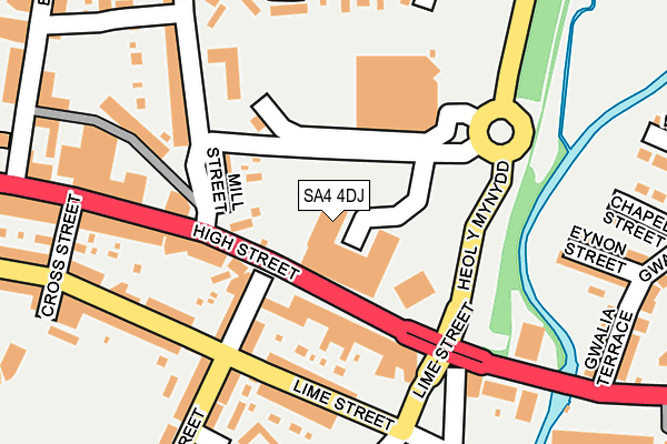
SA4 4DJ lies on High Street in Gorseinon, Swansea. SA4 4DJ is located in the Gorseinon and Penyrheol electoral ward, within the unitary authority of Swansea and the Welsh Parliamentary constituency of Gower. The Local Health Board is Swansea Bay University and the police force is South Wales. This postcode has been in use since January 1993.


GetTheData
Source: OS OpenMap – Local (Ordnance Survey)
Source: OS VectorMap District (Ordnance Survey)
Licence: Open Government Licence (requires attribution)
| Easting | 259324 |
| Northing | 198650 |
| Latitude | 51.668967 |
| Longitude | -4.035647 |
GetTheData
Source: Open Postcode Geo
Licence: Open Government Licence
| Street | High Street |
| Locality | Gorseinon |
| Town/City | Swansea |
| Country | Wales |
| Postcode District | SA4 |
| ➜ SA4 open data dashboard ➜ See where SA4 is on a map ➜ Where is Gorseinon? | |
GetTheData
Source: Land Registry Price Paid Data
Licence: Open Government Licence
Elevation or altitude of SA4 4DJ as distance above sea level:
| Metres | Feet | |
|---|---|---|
| Elevation | 10m | 33ft |
Elevation is measured from the approximate centre of the postcode, to the nearest point on an OS contour line from OS Terrain 50, which has contour spacing of ten vertical metres.
➜ How high above sea level am I? Find the elevation of your current position using your device's GPS.
GetTheData
Source: Open Postcode Elevation
Licence: Open Government Licence
| Ward | Gorseinon And Penyrheol |
| Constituency | Gower |
GetTheData
Source: ONS Postcode Database
Licence: Open Government Licence
1, HIGH STREET, GORSEINON, SWANSEA, SA4 4DJ 2003 29 AUG £125,000 |
GetTheData
Source: HM Land Registry Price Paid Data
Licence: Contains HM Land Registry data © Crown copyright and database right 2024. This data is licensed under the Open Government Licence v3.0.
| December 2023 | Other theft | On or near Petrol Station | 334m |
| November 2023 | Other theft | On or near Parking Area | 163m |
| July 2023 | Anti-social behaviour | On or near Petrol Station | 334m |
| ➜ Get more crime data in our Crime section | |||
GetTheData
Source: data.police.uk
Licence: Open Government Licence
| Somerfield (High Street) | Gorseinon | 52m |
| Somerfield (High Street) | Gorseinon | 93m |
| Parc Melin Mynach (Heol Y Mynydd) | Gorseinon | 347m |
| Llys Gwalia (Gorseinon Road) | Gorseinon | 398m |
| Llys Gwalia (Gorseinon Road) | Gorseinon | 457m |
| Gowerton Station | 2.3km |
| Llangennech Station | 3.9km |
| Bynea Station | 4.4km |
GetTheData
Source: NaPTAN
Licence: Open Government Licence
GetTheData
Source: ONS Postcode Database
Licence: Open Government Licence


➜ Get more ratings from the Food Standards Agency
GetTheData
Source: Food Standards Agency
Licence: FSA terms & conditions
| Last Collection | |||
|---|---|---|---|
| Location | Mon-Fri | Sat | Distance |
| Trinity Street | 17:45 | 12:45 | 98m |
| Gorseinon P O | 17:45 | 12:30 | 455m |
| Pontardulais Road | 17:30 | 13:15 | 532m |
GetTheData
Source: Dracos
Licence: Creative Commons Attribution-ShareAlike
| School | Phase of Education | Distance |
|---|---|---|
| Ysgol Gynradd Gymraeg Pontybrenin Loughor Road, Gorseinon, Swansea, SA4 6AU | Not applicable | 755m |
| Pontybrenin Primary School Glyn Rhosyn, Gorseinon, Swansea, SA4 6HX | Not applicable | 755m |
| Penyrheol Comprehensive School Pontarddulais Road, Gorseinon, Swansea, SA4 4FG | Not applicable | 772m |
GetTheData
Source: Edubase
Licence: Open Government Licence
The below table lists the International Territorial Level (ITL) codes (formerly Nomenclature of Territorial Units for Statistics (NUTS) codes) and Local Administrative Units (LAU) codes for SA4 4DJ:
| ITL 1 Code | Name |
|---|---|
| TLL | Wales |
| ITL 2 Code | Name |
| TLL1 | West Wales and The Valleys |
| ITL 3 Code | Name |
| TLL18 | Swansea |
| LAU 1 Code | Name |
| W06000011 | Swansea |
GetTheData
Source: ONS Postcode Directory
Licence: Open Government Licence
The below table lists the Census Output Area (OA), Lower Layer Super Output Area (LSOA), and Middle Layer Super Output Area (MSOA) for SA4 4DJ:
| Code | Name | |
|---|---|---|
| OA | W00010076 | |
| LSOA | W01000773 | Swansea 005A |
| MSOA | W02000172 | Swansea 005 |
GetTheData
Source: ONS Postcode Directory
Licence: Open Government Licence
| SA4 4DA | Rhydymardy | 82m |
| SA4 4BX | High Street | 100m |
| SA4 4BZ | Mill Street | 106m |
| SA4 4BT | High Street | 137m |
| SA4 4EF | Lime Street | 143m |
| SA4 4EQ | Trinity Street | 193m |
| SA4 4BR | High Street | 203m |
| SA4 4EE | Lime Street | 216m |
| SA4 4PJ | Cwrt Rhian | 223m |
| SA4 4BU | Cross Street | 235m |
GetTheData
Source: Open Postcode Geo; Land Registry Price Paid Data
Licence: Open Government Licence