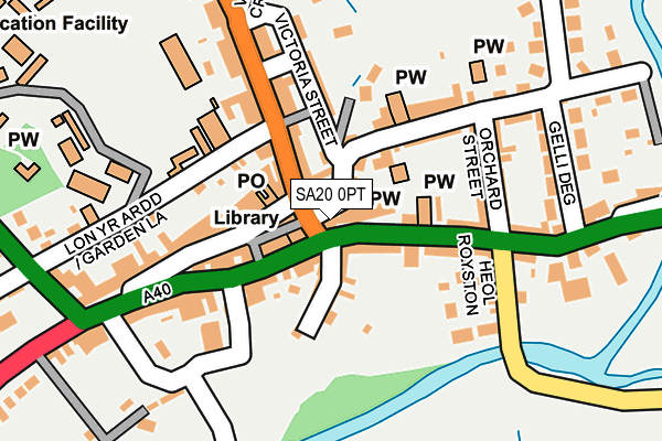
SA20 0PT lies on High Street in Llandovery. SA20 0PT is located in the Llandovery electoral ward, within the unitary authority of Carmarthenshire and the Welsh Parliamentary constituency of Carmarthen East and Dinefwr. The Local Health Board is Hywel Dda University and the police force is Dyfed-Powys. This postcode has been in use since January 1980.


GetTheData
Source: OS OpenMap – Local (Ordnance Survey)
Source: OS VectorMap District (Ordnance Survey)
Licence: Open Government Licence (requires attribution)
| Easting | 276816 |
| Northing | 234381 |
| Latitude | 51.994172 |
| Longitude | -3.795558 |
GetTheData
Source: Open Postcode Geo
Licence: Open Government Licence
| Street | High Street |
| Town/City | Llandovery |
| Country | Wales |
| Postcode District | SA20 |
| ➜ SA20 open data dashboard ➜ See where SA20 is on a map ➜ Where is Llandovery? | |
GetTheData
Source: Land Registry Price Paid Data
Licence: Open Government Licence
Elevation or altitude of SA20 0PT as distance above sea level:
| Metres | Feet | |
|---|---|---|
| Elevation | 70m | 230ft |
Elevation is measured from the approximate centre of the postcode, to the nearest point on an OS contour line from OS Terrain 50, which has contour spacing of ten vertical metres.
➜ How high above sea level am I? Find the elevation of your current position using your device's GPS.
GetTheData
Source: Open Postcode Elevation
Licence: Open Government Licence
| Ward | Llandovery |
| Constituency | Carmarthen East And Dinefwr |
GetTheData
Source: ONS Postcode Database
Licence: Open Government Licence
6, HIGH STREET, LLANDOVERY, SA20 0PT 2006 10 NOV £245,000 |
2, HIGH STREET, LLANDOVERY, SA20 0PT 2003 23 OCT £60,000 |
2, HIGH STREET, LLANDOVERY, SA20 0PT 1998 24 AUG £119,000 |
GetTheData
Source: HM Land Registry Price Paid Data
Licence: Contains HM Land Registry data © Crown copyright and database right 2024. This data is licensed under the Open Government Licence v3.0.
| November 2023 | Violence and sexual offences | On or near Water Street | 31m |
| October 2023 | Drugs | On or near Parking Area | 494m |
| September 2023 | Other theft | On or near Water Street | 31m |
| ➜ Get more crime data in our Crime section | |||
GetTheData
Source: data.police.uk
Licence: Open Government Licence
| Town Clock (Stone Street) | Llandovery | 34m |
| Post Office (Market Square) | Llandovery | 52m |
| Car Park (Grounds) | Llandovery | 135m |
| Fire Station (New Road) | Llandovery | 378m |
| Pantycelyn School (Cilycwm Road) | Llandovery | 459m |
| Llandovery Station | 0.5km |
GetTheData
Source: NaPTAN
Licence: Open Government Licence
GetTheData
Source: ONS Postcode Database
Licence: Open Government Licence


➜ Get more ratings from the Food Standards Agency
GetTheData
Source: Food Standards Agency
Licence: FSA terms & conditions
| Last Collection | |||
|---|---|---|---|
| Location | Mon-Fri | Sat | Distance |
| Llandovery P O | 17:30 | 12:30 | 53m |
| Mount Pleasant | 17:00 | 09:00 | 3,925m |
GetTheData
Source: Dracos
Licence: Creative Commons Attribution-ShareAlike
| School | Phase of Education | Distance |
|---|---|---|
| Coleg Llanymddyfri Queensway, Llandovery, Carmarthenshire, SA20 0EE | Not applicable | 359m |
| Ysgol Rhys Prichard Llanfair Road, Llandovery, Carmarthenshire, SA20 0HY | Not applicable | 369m |
GetTheData
Source: Edubase
Licence: Open Government Licence
The below table lists the International Territorial Level (ITL) codes (formerly Nomenclature of Territorial Units for Statistics (NUTS) codes) and Local Administrative Units (LAU) codes for SA20 0PT:
| ITL 1 Code | Name |
|---|---|
| TLL | Wales |
| ITL 2 Code | Name |
| TLL1 | West Wales and The Valleys |
| ITL 3 Code | Name |
| TLL14 | South West Wales |
| LAU 1 Code | Name |
| W06000010 | Carmarthenshire |
GetTheData
Source: ONS Postcode Directory
Licence: Open Government Licence
The below table lists the Census Output Area (OA), Lower Layer Super Output Area (LSOA), and Middle Layer Super Output Area (MSOA) for SA20 0PT:
| Code | Name | |
|---|---|---|
| OA | W00003651 | |
| LSOA | W01000679 | Carmarthenshire 002D |
| MSOA | W02000143 | Carmarthenshire 002 |
GetTheData
Source: ONS Postcode Directory
Licence: Open Government Licence
| SA20 0BS | Water Street | 23m |
| SA20 0BT | Water Street | 40m |
| SA20 0BX | Stone Street | 51m |
| SA20 0AW | Kings Road | 74m |
| SA20 0AN | Castle Street | 76m |
| SA20 0PU | High Street | 80m |
| SA20 0AB | Market Square | 80m |
| SA20 0JR | Stone Street | 82m |
| SA20 0AA | Market Square | 86m |
| SA20 0BU | Queen Street | 133m |
GetTheData
Source: Open Postcode Geo; Land Registry Price Paid Data
Licence: Open Government Licence