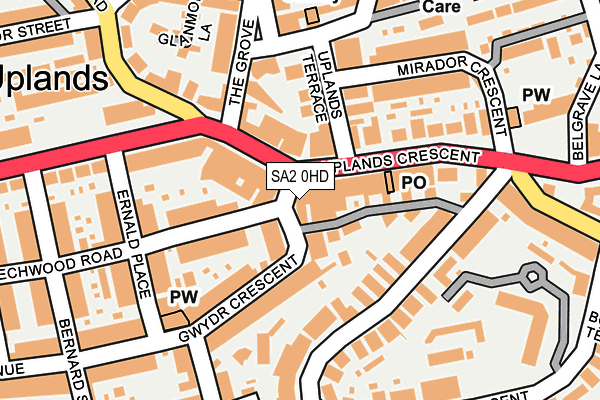
SA2 0HD lies on Gwydr Square in Uplands, Swansea. SA2 0HD is located in the Uplands electoral ward, within the unitary authority of Swansea and the Welsh Parliamentary constituency of Swansea West. The Local Health Board is Swansea Bay University and the police force is South Wales. This postcode has been in use since January 1980.


GetTheData
Source: OS OpenMap – Local (Ordnance Survey)
Source: OS VectorMap District (Ordnance Survey)
Licence: Open Government Licence (requires attribution)
| Easting | 263955 |
| Northing | 192836 |
| Latitude | 51.617859 |
| Longitude | -3.966442 |
GetTheData
Source: Open Postcode Geo
Licence: Open Government Licence
| Street | Gwydr Square |
| Locality | Uplands |
| Town/City | Swansea |
| Country | Wales |
| Postcode District | SA2 |
| ➜ SA2 open data dashboard ➜ See where SA2 is on a map ➜ Where is Swansea? | |
GetTheData
Source: Land Registry Price Paid Data
Licence: Open Government Licence
Elevation or altitude of SA2 0HD as distance above sea level:
| Metres | Feet | |
|---|---|---|
| Elevation | 40m | 131ft |
Elevation is measured from the approximate centre of the postcode, to the nearest point on an OS contour line from OS Terrain 50, which has contour spacing of ten vertical metres.
➜ How high above sea level am I? Find the elevation of your current position using your device's GPS.
GetTheData
Source: Open Postcode Elevation
Licence: Open Government Licence
| Ward | Uplands |
| Constituency | Swansea West |
GetTheData
Source: ONS Postcode Database
Licence: Open Government Licence
| November 2023 | Violence and sexual offences | On or near Hawthorne Avenue | 459m |
| October 2023 | Public order | On or near Hawthorne Avenue | 459m |
| July 2023 | Vehicle crime | On or near Hawthorne Avenue | 459m |
| ➜ Gwydr Square crime map and outcomes | |||
GetTheData
Source: data.police.uk
Licence: Open Government Licence
| Gwydr Crescent Shops (Gwydr Crecsent) | Uplands | 26m |
| Gwydr Square (Gwydr Crecsent) | Uplands | 33m |
| Post Office (Uplands Crescent) | Uplands | 70m |
| Post Office (Uplands Crescent) | Uplands | 86m |
| Shops (Uplands Crescent) | Uplands | 89m |
| Swansea Station | 1.9km |
| Gowerton Station | 5.9km |
GetTheData
Source: NaPTAN
Licence: Open Government Licence
GetTheData
Source: ONS Postcode Database
Licence: Open Government Licence


➜ Get more ratings from the Food Standards Agency
GetTheData
Source: Food Standards Agency
Licence: FSA terms & conditions
| Last Collection | |||
|---|---|---|---|
| Location | Mon-Fri | Sat | Distance |
| Uplands P O | 18:15 | 13:00 | 68m |
| Marlborough Road P O | 18:15 | 13:30 | 352m |
| Cwmdonkin Drive | 18:00 | 12:45 | 404m |
GetTheData
Source: Dracos
Licence: Creative Commons Attribution-ShareAlike
| School | Phase of Education | Distance |
|---|---|---|
| Y.G.G. Bryn-Y-Mor Heol St Alban, Brynmill, Abertawe, SA2 0BP | Not applicable | 451m |
| Ffynone House School Trust 36 St James's Crescent, Uplands, Swansea, SA1 6DR | Not applicable | 483m |
| Oakleigh House School 38 Penlan Crescent, Uplands, Swansea, SA2 0RL | Not applicable | 593m |
GetTheData
Source: Edubase
Licence: Open Government Licence
The below table lists the International Territorial Level (ITL) codes (formerly Nomenclature of Territorial Units for Statistics (NUTS) codes) and Local Administrative Units (LAU) codes for SA2 0HD:
| ITL 1 Code | Name |
|---|---|
| TLL | Wales |
| ITL 2 Code | Name |
| TLL1 | West Wales and The Valleys |
| ITL 3 Code | Name |
| TLL18 | Swansea |
| LAU 1 Code | Name |
| W06000011 | Swansea |
GetTheData
Source: ONS Postcode Directory
Licence: Open Government Licence
The below table lists the Census Output Area (OA), Lower Layer Super Output Area (LSOA), and Middle Layer Super Output Area (MSOA) for SA2 0HD:
| Code | Name | |
|---|---|---|
| OA | W00004646 | |
| LSOA | W01000874 | Swansea 024F |
| MSOA | W02000191 | Swansea 024 |
GetTheData
Source: ONS Postcode Directory
Licence: Open Government Licence
| SA2 0NP | Uplands Crescent | 39m |
| SA2 0AA | Gwydr Crescent | 57m |
| SA2 0EY | Uplands Crescent | 67m |
| SA2 0PG | Uplands Crescent | 68m |
| SA2 0EX | Uplands Crescent | 92m |
| SA2 0HL | Beechwood Road | 100m |
| SA2 0NX | Uplands Crescent | 102m |
| SA2 0QR | The Grove | 122m |
| SA2 0AB | Gwydr Crescent | 124m |
| SA2 0PB | Uplands Crescent | 138m |
GetTheData
Source: Open Postcode Geo; Land Registry Price Paid Data
Licence: Open Government Licence