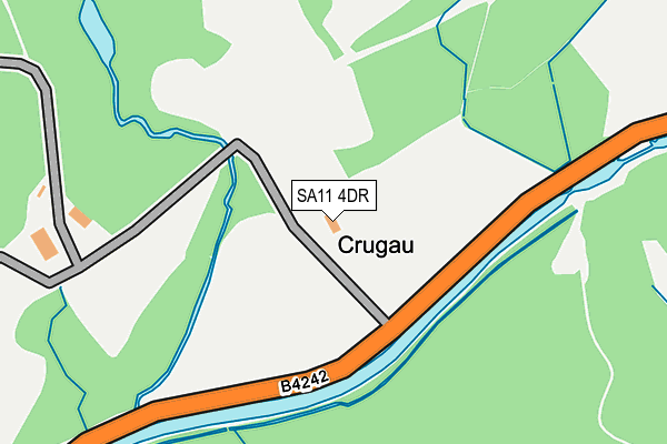
SA11 4DR is located in the Blaengwrach and Glynneath West electoral ward, within the unitary authority of Neath Port Talbot and the Welsh Parliamentary constituency of Neath. The Local Health Board is Swansea Bay University and the police force is South Wales. This postcode has been in use since January 1980.


GetTheData
Source: OS OpenMap – Local (Ordnance Survey)
Source: OS VectorMap District (Ordnance Survey)
Licence: Open Government Licence (requires attribution)
| Easting | 283419 |
| Northing | 203679 |
| Latitude | 51.719686 |
| Longitude | -3.689080 |
GetTheData
Source: Open Postcode Geo
Licence: Open Government Licence
| Country | Wales |
| Postcode District | SA11 |
| ➜ SA11 open data dashboard ➜ See where SA11 is on a map | |
GetTheData
Source: Land Registry Price Paid Data
Licence: Open Government Licence
Elevation or altitude of SA11 4DR as distance above sea level:
| Metres | Feet | |
|---|---|---|
| Elevation | 70m | 230ft |
Elevation is measured from the approximate centre of the postcode, to the nearest point on an OS contour line from OS Terrain 50, which has contour spacing of ten vertical metres.
➜ How high above sea level am I? Find the elevation of your current position using your device's GPS.
GetTheData
Source: Open Postcode Elevation
Licence: Open Government Licence
| Ward | Blaengwrach And Glynneath West |
| Constituency | Neath |
GetTheData
Source: ONS Postcode Database
Licence: Open Government Licence
| Forest Lodge (Glynneath Road) | Resolven | 517m |
| Forest Lodge (Glynneath Road) | Resolven | 589m |
| Rheola Works (Glynneath Road) | Resolven | 700m |
| Rheola Market (Glynneath Road) | Resolven | 780m |
| Heol Tonmaen (Ynysyfach Avenue) | Resolven | 825m |
GetTheData
Source: NaPTAN
Licence: Open Government Licence
GetTheData
Source: ONS Postcode Database
Licence: Open Government Licence


➜ Get more ratings from the Food Standards Agency
GetTheData
Source: Food Standards Agency
Licence: FSA terms & conditions
| School | Phase of Education | Distance |
|---|---|---|
| Ynysfach Primary School Resolven, Neath, SA11 4AB | Not applicable | 1.2km |
| Blaengwrach Primary School Heol Wenallt, Cwmgwrach, Neath, SA11 5PS | Not applicable | 3.7km |
| Creunant Primary School School Road, Crynant, Neath, SA10 8NS | Not applicable | 4.3km |
GetTheData
Source: Edubase
Licence: Open Government Licence
The below table lists the International Territorial Level (ITL) codes (formerly Nomenclature of Territorial Units for Statistics (NUTS) codes) and Local Administrative Units (LAU) codes for SA11 4DR:
| ITL 1 Code | Name |
|---|---|
| TLL | Wales |
| ITL 2 Code | Name |
| TLL1 | West Wales and The Valleys |
| ITL 3 Code | Name |
| TLL17 | Bridgend and Neath Port Talbot |
| LAU 1 Code | Name |
| W06000012 | Neath Port Talbot |
GetTheData
Source: ONS Postcode Directory
Licence: Open Government Licence
The below table lists the Census Output Area (OA), Lower Layer Super Output Area (LSOA), and Middle Layer Super Output Area (MSOA) for SA11 4DR:
| Code | Name | |
|---|---|---|
| OA | W00004930 | |
| LSOA | W01000925 | Neath Port Talbot 003B |
| MSOA | W02000201 | Neath Port Talbot 003 |
GetTheData
Source: ONS Postcode Directory
Licence: Open Government Licence
| SA11 4LR | Ynys Nedd | 766m |
| SA11 4LP | Ynysfach Avenue | 795m |
| SA11 4LW | Heol Tonmaen | 806m |
| SA11 4DP | Glynneath Road | 818m |
| SA11 4LS | Ynys Fawr Avenue | 827m |
| SA11 4LH | Ynysfach Avenue | 863m |
| SA11 4LT | Ynys Fawr Avenue | 871m |
| SA11 4LG | New Inn Place | 903m |
| SA11 4LF | Rose Cottages | 918m |
| SA11 4HY | Commercial Road | 959m |
GetTheData
Source: Open Postcode Geo; Land Registry Price Paid Data
Licence: Open Government Licence