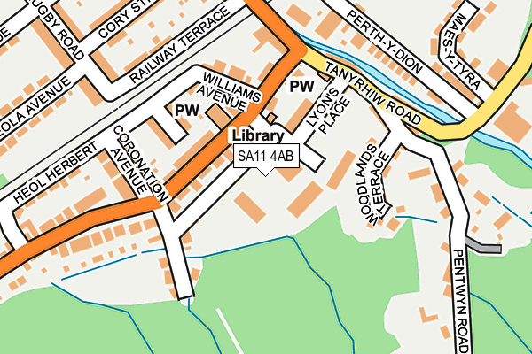
SA11 4AB is located in the Resolven and Tonna electoral ward, within the unitary authority of Neath Port Talbot and the Welsh Parliamentary constituency of Neath. The Local Health Board is Swansea Bay University and the police force is South Wales. This postcode has been in use since January 1980.


GetTheData
Source: OS OpenMap – Local (Ordnance Survey)
Source: OS VectorMap District (Ordnance Survey)
Licence: Open Government Licence (requires attribution)
| Easting | 283027 |
| Northing | 202484 |
| Latitude | 51.708864 |
| Longitude | -3.694351 |
GetTheData
Source: Open Postcode Geo
Licence: Open Government Licence
| Country | Wales |
| Postcode District | SA11 |
| ➜ SA11 open data dashboard ➜ See where SA11 is on a map ➜ Where is Resolven? | |
GetTheData
Source: Land Registry Price Paid Data
Licence: Open Government Licence
Elevation or altitude of SA11 4AB as distance above sea level:
| Metres | Feet | |
|---|---|---|
| Elevation | 40m | 131ft |
Elevation is measured from the approximate centre of the postcode, to the nearest point on an OS contour line from OS Terrain 50, which has contour spacing of ten vertical metres.
➜ How high above sea level am I? Find the elevation of your current position using your device's GPS.
GetTheData
Source: Open Postcode Elevation
Licence: Open Government Licence
| Ward | Resolven And Tonna |
| Constituency | Neath |
GetTheData
Source: ONS Postcode Database
Licence: Open Government Licence
| October 2023 | Public order | On or near John Street | 473m |
| September 2023 | Violence and sexual offences | On or near Williams Avenue | 138m |
| August 2023 | Violence and sexual offences | On or near Williams Avenue | 138m |
| ➜ Get more crime data in our Crime section | |||
GetTheData
Source: data.police.uk
Licence: Open Government Licence
| Church Hall (Neath Road) | Resolven | 153m |
| Church Hall (Neath Road) | Resolven | 171m |
| Heol Herbert (Neath Road) | Resolven | 249m |
| Heol Herbert (Neath Road) | Resolven | 312m |
| Health Centre (Ynysfach Avenue) | Resolven | 390m |
GetTheData
Source: NaPTAN
Licence: Open Government Licence
GetTheData
Source: ONS Postcode Database
Licence: Open Government Licence


➜ Get more ratings from the Food Standards Agency
GetTheData
Source: Food Standards Agency
Licence: FSA terms & conditions
| School | Phase of Education | Distance |
|---|---|---|
| Ynysfach Primary School Resolven, Neath, SA11 4AB | Not applicable | 37m |
| Creunant Primary School School Road, Crynant, Neath, SA10 8NS | Not applicable | 4.5km |
| Blaengwrach Primary School Heol Wenallt, Cwmgwrach, Neath, SA11 5PS | Not applicable | 4.6km |
GetTheData
Source: Edubase
Licence: Open Government Licence
The below table lists the International Territorial Level (ITL) codes (formerly Nomenclature of Territorial Units for Statistics (NUTS) codes) and Local Administrative Units (LAU) codes for SA11 4AB:
| ITL 1 Code | Name |
|---|---|
| TLL | Wales |
| ITL 2 Code | Name |
| TLL1 | West Wales and The Valleys |
| ITL 3 Code | Name |
| TLL17 | Bridgend and Neath Port Talbot |
| LAU 1 Code | Name |
| W06000012 | Neath Port Talbot |
GetTheData
Source: ONS Postcode Directory
Licence: Open Government Licence
The below table lists the Census Output Area (OA), Lower Layer Super Output Area (LSOA), and Middle Layer Super Output Area (MSOA) for SA11 4AB:
| Code | Name | |
|---|---|---|
| OA | W00005068 | |
| LSOA | W01000953 | Neath Port Talbot 005B |
| MSOA | W02000203 | Neath Port Talbot 005 |
GetTheData
Source: ONS Postcode Directory
Licence: Open Government Licence
| SA11 4AA | Neath Road | 86m |
| SA11 4AL | Nant Y Gleisaid | 109m |
| SA11 4AE | Thomas Terrace | 123m |
| SA11 4ND | Lyons Place | 128m |
| SA11 4AF | Coronation Avenue | 147m |
| SA11 4AD | Williams Avenue | 152m |
| SA11 4NG | Woodlands Terrace | 154m |
| SA11 4NE | Davies Terrace | 180m |
| SA11 4AH | Neath Road | 190m |
| SA11 4NA | Commercial Road | 190m |
GetTheData
Source: Open Postcode Geo; Land Registry Price Paid Data
Licence: Open Government Licence