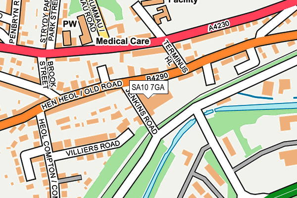
SA10 7GA is located in the Dyffryn electoral ward, within the unitary authority of Neath Port Talbot and the Welsh Parliamentary constituency of Neath. The Local Health Board is Swansea Bay University and the police force is South Wales. This postcode has been in use since December 1997.


GetTheData
Source: OS OpenMap – Local (Ordnance Survey)
Source: OS VectorMap District (Ordnance Survey)
Licence: Open Government Licence (requires attribution)
| Easting | 273205 |
| Northing | 197287 |
| Latitude | 51.660020 |
| Longitude | -3.834525 |
GetTheData
Source: Open Postcode Geo
Licence: Open Government Licence
| Country | Wales |
| Postcode District | SA10 |
| ➜ SA10 open data dashboard ➜ See where SA10 is on a map ➜ Where is Neath? | |
GetTheData
Source: Land Registry Price Paid Data
Licence: Open Government Licence
Elevation or altitude of SA10 7GA as distance above sea level:
| Metres | Feet | |
|---|---|---|
| Elevation | 20m | 66ft |
Elevation is measured from the approximate centre of the postcode, to the nearest point on an OS contour line from OS Terrain 50, which has contour spacing of ten vertical metres.
➜ How high above sea level am I? Find the elevation of your current position using your device's GPS.
GetTheData
Source: Open Postcode Elevation
Licence: Open Government Licence
| Ward | Dyffryn |
| Constituency | Neath |
GetTheData
Source: ONS Postcode Database
Licence: Open Government Licence
| May 2023 | Vehicle crime | On or near Hill Road | 355m |
| February 2023 | Violence and sexual offences | On or near Hill Road | 355m |
| February 2023 | Violence and sexual offences | On or near Hill Road | 355m |
| ➜ Get more crime data in our Crime section | |||
GetTheData
Source: data.police.uk
Licence: Open Government Licence
| White Gates (New Road) | Neath Abbey | 118m |
| White Gates (New Road) | Neath Abbey | 143m |
| Dynevor Road | Pentreffynnon | 438m |
| Sunnyland Crescent (Dynevor Road) | Neath Abbey | 454m |
| Rock & Fountain Inn (Burrows Road) | Skewen | 505m |
| Skewen Station | 0.8km |
| Neath Station | 1.9km |
| Briton Ferry Station | 2.7km |
GetTheData
Source: NaPTAN
Licence: Open Government Licence
GetTheData
Source: ONS Postcode Database
Licence: Open Government Licence


➜ Get more ratings from the Food Standards Agency
GetTheData
Source: Food Standards Agency
Licence: FSA terms & conditions
| Last Collection | |||
|---|---|---|---|
| Location | Mon-Fri | Sat | Distance |
| Neath Delivery Office | 18:30 | 13:00 | 1,922m |
| New Street | 18:00 | 12:30 | 2,090m |
| Cimla Cres | 17:00 | 11:45 | 2,947m |
GetTheData
Source: Dracos
Licence: Creative Commons Attribution-ShareAlike
| School | Phase of Education | Distance |
|---|---|---|
| Ysgol Gynradd Gymraeg Tregeles St. Johns Terrace, Neath Abbey, Neath, SA10 7ND | Not applicable | 196m |
| Coedffranc Primary School Stanley Road, Skewen, Neath, SA10 6LP | Not applicable | 665m |
| Dwr Y Felin Comprehensive School Dwr Y Felin Road, Neath, SA10 7RE | Not applicable | 1.6km |
GetTheData
Source: Edubase
Licence: Open Government Licence
The below table lists the International Territorial Level (ITL) codes (formerly Nomenclature of Territorial Units for Statistics (NUTS) codes) and Local Administrative Units (LAU) codes for SA10 7GA:
| ITL 1 Code | Name |
|---|---|
| TLL | Wales |
| ITL 2 Code | Name |
| TLL1 | West Wales and The Valleys |
| ITL 3 Code | Name |
| TLL17 | Bridgend and Neath Port Talbot |
| LAU 1 Code | Name |
| W06000012 | Neath Port Talbot |
GetTheData
Source: ONS Postcode Directory
Licence: Open Government Licence
The below table lists the Census Output Area (OA), Lower Layer Super Output Area (LSOA), and Middle Layer Super Output Area (MSOA) for SA10 7GA:
| Code | Name | |
|---|---|---|
| OA | W00004914 | |
| LSOA | W01000922 | Neath Port Talbot 007C |
| MSOA | W02000205 | Neath Port Talbot 007 |
GetTheData
Source: ONS Postcode Directory
Licence: Open Government Licence
| SA10 7LT | Old Road | 78m |
| SA10 7NA | St Johns Terrace | 96m |
| SA10 7NJ | Wesley Court | 109m |
| SA10 7LR | Old Road | 115m |
| SA10 7NB | St Johns Terrace | 125m |
| SA10 6AS | White Gates Court | 127m |
| SA10 7NT | St Johns Terrace | 127m |
| SA10 6AT | Old Road | 135m |
| SA10 6AU | Villiers Road | 149m |
| SA10 6AR | Old Road | 154m |
GetTheData
Source: Open Postcode Geo; Land Registry Price Paid Data
Licence: Open Government Licence