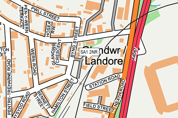
SA1 2NR is located in the Landore electoral ward, within the unitary authority of Swansea and the Welsh Parliamentary constituency of Swansea East. The Local Health Board is Swansea Bay University and the police force is South Wales. This postcode has been in use since January 2006.


GetTheData
Source: OS OpenMap – Local (Ordnance Survey)
Source: OS VectorMap District (Ordnance Survey)
Licence: Open Government Licence (requires attribution)
| Easting | 265958 |
| Northing | 195633 |
| Latitude | 51.643479 |
| Longitude | -3.938618 |
GetTheData
Source: Open Postcode Geo
Licence: Open Government Licence
| Country | Wales |
| Postcode District | SA1 |
| ➜ SA1 open data dashboard ➜ See where SA1 is on a map ➜ Where is Swansea? | |
GetTheData
Source: Land Registry Price Paid Data
Licence: Open Government Licence
Elevation or altitude of SA1 2NR as distance above sea level:
| Metres | Feet | |
|---|---|---|
| Elevation | 20m | 66ft |
Elevation is measured from the approximate centre of the postcode, to the nearest point on an OS contour line from OS Terrain 50, which has contour spacing of ten vertical metres.
➜ How high above sea level am I? Find the elevation of your current position using your device's GPS.
GetTheData
Source: Open Postcode Elevation
Licence: Open Government Licence
| Ward | Landore |
| Constituency | Swansea East |
GetTheData
Source: ONS Postcode Database
Licence: Open Government Licence
| January 2024 | Other theft | On or near Petrol Station | 287m |
| January 2024 | Public order | On or near Petrol Station | 287m |
| November 2023 | Violence and sexual offences | On or near Field Street | 168m |
| ➜ Get more crime data in our Crime section | |||
GetTheData
Source: data.police.uk
Licence: Open Government Licence
| Liberty Stadium (Neath Road) | Landore | 126m |
| Liberty Stadium (Neath Road) | Landore | 134m |
| Landore (Neath Road) | Landore | 156m |
| Landore (Neath Road) | Landore | 315m |
| Brynhyfryd Square (Cwm Level Road) | Manselton | 469m |
| Swansea Station | 2km |
| Llansamlet Station | 4.2km |
GetTheData
Source: NaPTAN
Licence: Open Government Licence
GetTheData
Source: ONS Postcode Database
Licence: Open Government Licence


➜ Get more ratings from the Food Standards Agency
GetTheData
Source: Food Standards Agency
Licence: FSA terms & conditions
| Last Collection | |||
|---|---|---|---|
| Location | Mon-Fri | Sat | Distance |
| Landore Old P O | 18:30 | 11:00 | 127m |
| Brynhyfryd P O | 18:15 | 12:30 | 477m |
| Plasmarl P O | 18:30 | 11:30 | 712m |
GetTheData
Source: Dracos
Licence: Creative Commons Attribution-ShareAlike
| School | Phase of Education | Distance |
|---|---|---|
| Plasmarl Primary School Britannia Road, Plasmarl, Swansea, SA6 8LH | Not applicable | 646m |
| Pentrehafod School Pentremawr Road, Hafod, Swansea, SA1 2NN | Not applicable | 646m |
| Hafod Primary School Odo Street, Hafod, Swansea, SA1 2LT | Not applicable | 1.1km |
GetTheData
Source: Edubase
Licence: Open Government Licence
The below table lists the International Territorial Level (ITL) codes (formerly Nomenclature of Territorial Units for Statistics (NUTS) codes) and Local Administrative Units (LAU) codes for SA1 2NR:
| ITL 1 Code | Name |
|---|---|
| TLL | Wales |
| ITL 2 Code | Name |
| TLL1 | West Wales and The Valleys |
| ITL 3 Code | Name |
| TLL18 | Swansea |
| LAU 1 Code | Name |
| W06000011 | Swansea |
GetTheData
Source: ONS Postcode Directory
Licence: Open Government Licence
The below table lists the Census Output Area (OA), Lower Layer Super Output Area (LSOA), and Middle Layer Super Output Area (MSOA) for SA1 2NR:
| Code | Name | |
|---|---|---|
| OA | W00004240 | |
| LSOA | W01000788 | Swansea 016D |
| MSOA | W02000183 | Swansea 016 |
GetTheData
Source: ONS Postcode Directory
Licence: Open Government Licence
| SA1 2NX | Byng Street | 99m |
| SA1 2NY | Glandwr Crescent | 126m |
| SA1 2NT | Siloh Road | 145m |
| SA1 2JY | Greenfield Terrace | 151m |
| SA1 2NZ | Mysydd Road | 157m |
| SA1 2QJ | Hamilton Street | 165m |
| SA1 2JZ | Field Street | 177m |
| SA1 2PF | Hosea Row | 183m |
| SA1 2PE | Siloh Road | 187m |
| SA1 2JG | Neath Road | 190m |
GetTheData
Source: Open Postcode Geo; Land Registry Price Paid Data
Licence: Open Government Licence