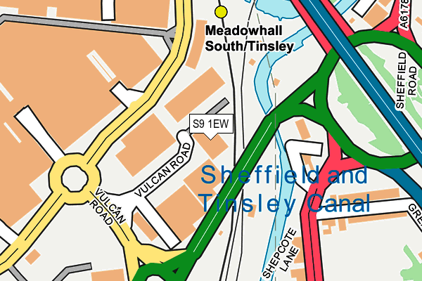
S9 1EW is located in the Darnall electoral ward, within the metropolitan district of Sheffield and the English Parliamentary constituency of Sheffield South East. The Sub Integrated Care Board (ICB) Location is NHS South Yorkshire ICB - 03N and the police force is South Yorkshire. This postcode has been in use since January 1983.


GetTheData
Source: OS OpenMap – Local (Ordnance Survey)
Source: OS VectorMap District (Ordnance Survey)
Licence: Open Government Licence (requires attribution)
| Easting | 439550 |
| Northing | 390822 |
| Latitude | 53.412750 |
| Longitude | -1.406463 |
GetTheData
Source: Open Postcode Geo
Licence: Open Government Licence
| Country | England |
| Postcode District | S9 |
➜ See where S9 is on a map ➜ Where is Sheffield? | |
GetTheData
Source: Land Registry Price Paid Data
Licence: Open Government Licence
Elevation or altitude of S9 1EW as distance above sea level:
| Metres | Feet | |
|---|---|---|
| Elevation | 40m | 131ft |
Elevation is measured from the approximate centre of the postcode, to the nearest point on an OS contour line from OS Terrain 50, which has contour spacing of ten vertical metres.
➜ How high above sea level am I? Find the elevation of your current position using your device's GPS.
GetTheData
Source: Open Postcode Elevation
Licence: Open Government Licence
| Ward | Darnall |
| Constituency | Sheffield South East |
GetTheData
Source: ONS Postcode Database
Licence: Open Government Licence
| Tinsley Roundabout (Sheffield Road) | Tinsley | 125m |
| Tinsley Roundabout (Sheffield Road) | Tinsley | 140m |
| Greasbrough Road (Shepcote Lane) | Tinsley | 264m |
| Meadowhall Way | Meadowhall | 280m |
| Meadowhall Way | Meadowhall | 288m |
| Meadowhall South - Tinsley (Sheffield Supertram) (Off Meadowhall Way) | Meadowhall | 193m |
| Meadowhall Interchange (Sheffield Supertram) (Off Meadowhall Road) | Meadowhall | 667m |
| Carbrook (Sheffield Supertram) (Off Sheffield Road - Attercliffe Road) | Carbrook | 851m |
| Valley Centertainment (Sheffield Supertram) (Off Greenland Road) | Carbrook | 1,243m |
| Meadowhall Station | 0.7km |
| Darnall Station | 3.2km |
| Rotherham Central Station | 3.8km |
GetTheData
Source: NaPTAN
Licence: Open Government Licence
GetTheData
Source: ONS Postcode Database
Licence: Open Government Licence


➜ Get more ratings from the Food Standards Agency
GetTheData
Source: Food Standards Agency
Licence: FSA terms & conditions
| Last Collection | |||
|---|---|---|---|
| Location | Mon-Fri | Sat | Distance |
| Tinsley Post Office | 17:10 | 12:10 | 386m |
| Outside Sainsburys | 18:30 | 12:30 | 423m |
| Outside Sainsburys | 18:30 | 424m | |
GetTheData
Source: Dracos
Licence: Creative Commons Attribution-ShareAlike
| Risk of S9 1EW flooding from rivers and sea | Low |
| ➜ S9 1EW flood map | |
GetTheData
Source: Open Flood Risk by Postcode
Licence: Open Government Licence
The below table lists the International Territorial Level (ITL) codes (formerly Nomenclature of Territorial Units for Statistics (NUTS) codes) and Local Administrative Units (LAU) codes for S9 1EW:
| ITL 1 Code | Name |
|---|---|
| TLE | Yorkshire and The Humber |
| ITL 2 Code | Name |
| TLE3 | South Yorkshire |
| ITL 3 Code | Name |
| TLE32 | Sheffield |
| LAU 1 Code | Name |
| E08000019 | Sheffield |
GetTheData
Source: ONS Postcode Directory
Licence: Open Government Licence
The below table lists the Census Output Area (OA), Lower Layer Super Output Area (LSOA), and Middle Layer Super Output Area (MSOA) for S9 1EW:
| Code | Name | |
|---|---|---|
| OA | E00040038 | |
| LSOA | E01007913 | Sheffield 018C |
| MSOA | E02001628 | Sheffield 018 |
GetTheData
Source: ONS Postcode Directory
Licence: Open Government Licence
| S9 1UQ | Greasbro Road | 322m |
| S9 1RD | Sheffield Road | 362m |
| S9 1UG | Town Street | 454m |
| S9 1UN | Siemens Close | 476m |
| S9 1SU | Dundas Road | 526m |
| S9 1SN | Hatherley Road | 529m |
| S9 1SW | Dundas Road | 546m |
| S9 1UA | Bawtry Road | 556m |
| S9 1UR | Newburn Drive | 557m |
| S9 1UE | Bawtry Road | 557m |
GetTheData
Source: Open Postcode Geo; Land Registry Price Paid Data
Licence: Open Government Licence