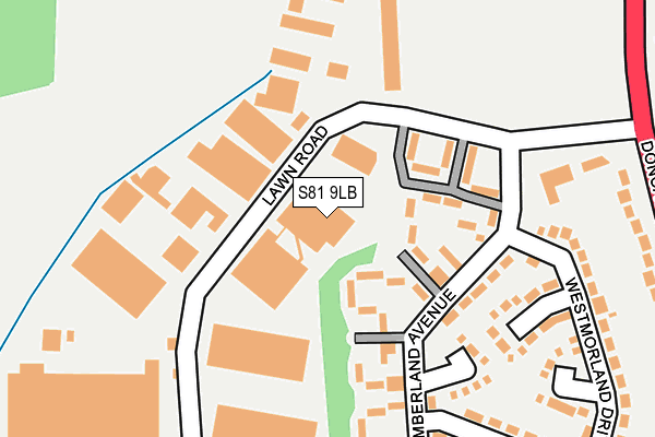
S81 9LB lies on Lawn Road in Carlton In Lindrick, Worksop. S81 9LB is located in the Carlton electoral ward, within the local authority district of Bassetlaw and the English Parliamentary constituency of Bassetlaw. The Sub Integrated Care Board (ICB) Location is NHS Nottingham and Nottinghamshire ICB - 02Q and the police force is Nottinghamshire. This postcode has been in use since January 1980.


GetTheData
Source: OS OpenMap – Local (Ordnance Survey)
Source: OS VectorMap District (Ordnance Survey)
Licence: Open Government Licence (requires attribution)
| Easting | 458292 |
| Northing | 385700 |
| Latitude | 53.364984 |
| Longitude | -1.125476 |
GetTheData
Source: Open Postcode Geo
Licence: Open Government Licence
| Street | Lawn Road |
| Locality | Carlton In Lindrick |
| Town/City | Worksop |
| Country | England |
| Postcode District | S81 |
| ➜ S81 open data dashboard ➜ See where S81 is on a map ➜ Where is Carlton in Lindrick? | |
GetTheData
Source: Land Registry Price Paid Data
Licence: Open Government Licence
Elevation or altitude of S81 9LB as distance above sea level:
| Metres | Feet | |
|---|---|---|
| Elevation | 30m | 98ft |
Elevation is measured from the approximate centre of the postcode, to the nearest point on an OS contour line from OS Terrain 50, which has contour spacing of ten vertical metres.
➜ How high above sea level am I? Find the elevation of your current position using your device's GPS.
GetTheData
Source: Open Postcode Elevation
Licence: Open Government Licence
| Ward | Carlton |
| Constituency | Bassetlaw |
GetTheData
Source: ONS Postcode Database
Licence: Open Government Licence
| July 2023 | Vehicle crime | On or near Westmorland Drive | 290m |
| November 2022 | Criminal damage and arson | On or near Westmorland Drive | 290m |
| November 2022 | Anti-social behaviour | On or near Westmorland Drive | 290m |
| ➜ Lawn Road crime map and outcomes | |||
GetTheData
Source: data.police.uk
Licence: Open Government Licence
| Northumberland Avenue | Costhorpe | 156m |
| Northumberland Avenue | Costhorpe | 185m |
| Lawn Road | Costhorpe | 254m |
| Lawn Road | Costhorpe | 283m |
| Doncaster Road | Costhorpe | 329m |
| Shireoaks Station | 5.3km |
GetTheData
Source: NaPTAN
Licence: Open Government Licence
Estimated total energy consumption in S81 9LB by fuel type, 2015.
| Consumption (kWh) | 119,935 |
|---|---|
| Meter count | 6 |
| Mean (kWh/meter) | 19,989 |
| Median (kWh/meter) | 19,914 |
GetTheData
Source: Postcode level gas estimates: 2015 (experimental)
Source: Postcode level electricity estimates: 2015 (experimental)
Licence: Open Government Licence
GetTheData
Source: ONS Postcode Database
Licence: Open Government Licence

➜ Get more ratings from the Food Standards Agency
GetTheData
Source: Food Standards Agency
Licence: FSA terms & conditions
| Last Collection | |||
|---|---|---|---|
| Location | Mon-Fri | Sat | Distance |
| 32 Northumberland Avenue | 16:00 | 10:00 | 159m |
| Cleveland Close | 16:00 | 09:30 | 289m |
| Costhorpe Villas | 16:00 | 10:30 | 579m |
GetTheData
Source: Dracos
Licence: Creative Commons Attribution-ShareAlike
| Facility | Distance |
|---|---|
| Costhorpe Sports Field Doncaster Road, Costhorpe, Worksop Grass Pitches | 312m |
| Costhorpe Cricket Ground Doncaster Road, Costhorpe, Worksop Grass Pitches | 581m |
| Langold Country Park Doncaster Road, Costhorpe, Worksop Grass Pitches | 1000m |
GetTheData
Source: Active Places
Licence: Open Government Licence
| School | Phase of Education | Distance |
|---|---|---|
| Kingston Park Academy Long Lane, Carlton-in-Lindrick, Worksop, S81 9AW | Primary | 1km |
| Ramsden Primary School High Road, Carlton-in-Lindrick, Worksop, S81 9DY | Primary | 1.5km |
| Langold Dyscarr Community School School Road, Langold, Worksop, S81 9PX | Primary | 1.7km |
GetTheData
Source: Edubase
Licence: Open Government Licence
The below table lists the International Territorial Level (ITL) codes (formerly Nomenclature of Territorial Units for Statistics (NUTS) codes) and Local Administrative Units (LAU) codes for S81 9LB:
| ITL 1 Code | Name |
|---|---|
| TLF | East Midlands (England) |
| ITL 2 Code | Name |
| TLF1 | Derbyshire and Nottinghamshire |
| ITL 3 Code | Name |
| TLF15 | North Nottinghamshire |
| LAU 1 Code | Name |
| E07000171 | Bassetlaw |
GetTheData
Source: ONS Postcode Directory
Licence: Open Government Licence
The below table lists the Census Output Area (OA), Lower Layer Super Output Area (LSOA), and Middle Layer Super Output Area (MSOA) for S81 9LB:
| Code | Name | |
|---|---|---|
| OA | E00142676 | |
| LSOA | E01028001 | Bassetlaw 004A |
| MSOA | E02005838 | Bassetlaw 004 |
GetTheData
Source: ONS Postcode Directory
Licence: Open Government Licence
| S81 9JP | Northumberland Avenue | 144m |
| S81 9LA | Sutherland Close | 256m |
| S81 9JT | Westmorland Drive | 305m |
| S81 9LE | Rotherham Baulk | 326m |
| S81 9JD | Chichester Walk | 352m |
| S81 9QX | Highfield Villas | 370m |
| S81 9RA | West View | 374m |
| S81 9JA | Beverley Walk | 396m |
| S81 9JF | Canterbury Walk | 401m |
| S81 9JY | Rotherham Baulk | 403m |
GetTheData
Source: Open Postcode Geo; Land Registry Price Paid Data
Licence: Open Government Licence