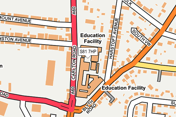
S81 7HP is located in the Worksop North East electoral ward, within the local authority district of Bassetlaw and the English Parliamentary constituency of Bassetlaw. The Sub Integrated Care Board (ICB) Location is NHS Nottingham and Nottinghamshire ICB - 02Q and the police force is Nottinghamshire. This postcode has been in use since January 1980.


GetTheData
Source: OS OpenMap – Local (Ordnance Survey)
Source: OS VectorMap District (Ordnance Survey)
Licence: Open Government Licence (requires attribution)
| Easting | 458701 |
| Northing | 380049 |
| Latitude | 53.314150 |
| Longitude | -1.120376 |
GetTheData
Source: Open Postcode Geo
Licence: Open Government Licence
| Country | England |
| Postcode District | S81 |
| ➜ S81 open data dashboard ➜ See where S81 is on a map ➜ Where is Worksop? | |
GetTheData
Source: Land Registry Price Paid Data
Licence: Open Government Licence
Elevation or altitude of S81 7HP as distance above sea level:
| Metres | Feet | |
|---|---|---|
| Elevation | 50m | 164ft |
Elevation is measured from the approximate centre of the postcode, to the nearest point on an OS contour line from OS Terrain 50, which has contour spacing of ten vertical metres.
➜ How high above sea level am I? Find the elevation of your current position using your device's GPS.
GetTheData
Source: Open Postcode Elevation
Licence: Open Government Licence
| Ward | Worksop North East |
| Constituency | Bassetlaw |
GetTheData
Source: ONS Postcode Database
Licence: Open Government Licence
| June 2023 | Public order | On or near Parking Area | 308m |
| June 2022 | Criminal damage and arson | On or near Further/Higher Educational Building | 36m |
| June 2022 | Burglary | On or near Further/Higher Educational Building | 36m |
| ➜ Get more crime data in our Crime section | |||
GetTheData
Source: data.police.uk
Licence: Open Government Licence
| North Notts College (Carlton Road) | Worksop | 28m |
| North Notts College (Carlton Road) | Worksop | 74m |
| North Notts College (Blyth Road) | Worksop | 96m |
| North Notts College (Blyth Road) | Worksop | 116m |
| The Baulk (Blyth Road) | Worksop | 245m |
| Worksop Station | 0.3km |
| Shireoaks Station | 3.4km |
GetTheData
Source: NaPTAN
Licence: Open Government Licence
GetTheData
Source: ONS Postcode Database
Licence: Open Government Licence


➜ Get more ratings from the Food Standards Agency
GetTheData
Source: Food Standards Agency
Licence: FSA terms & conditions
| Last Collection | |||
|---|---|---|---|
| Location | Mon-Fri | Sat | Distance |
| Carlton Road | 16:00 | 10:30 | 74m |
| Queensway | 16:00 | 10:30 | 308m |
| Blyth Road | 16:00 | 10:30 | 346m |
GetTheData
Source: Dracos
Licence: Creative Commons Attribution-ShareAlike
| Facility | Distance |
|---|---|
| North Nottinghamshire College Carlton Road, Worksop Health and Fitness Gym, Sports Hall | 29m |
| Norbridge Academy Stanley Street, Worksop Grass Pitches | 405m |
| Worksop Leisure Centre (Closed) Valley Road, Worksop Sports Hall, Studio, Swimming Pool, Health and Fitness Gym, Artificial Grass Pitch | 565m |
GetTheData
Source: Active Places
Licence: Open Government Licence
| School | Phase of Education | Distance |
|---|---|---|
| Norbridge Academy Stanley Street, Worksop, S81 7HX | Primary | 431m |
| Sir Edmund Hillary Academy Kingsway, Kilton, Worksop, S81 0AN | Primary | 567m |
| Outwood Academy Valley Valley Road, Worksop, S81 7EN | Secondary | 624m |
GetTheData
Source: Edubase
Licence: Open Government Licence
The below table lists the International Territorial Level (ITL) codes (formerly Nomenclature of Territorial Units for Statistics (NUTS) codes) and Local Administrative Units (LAU) codes for S81 7HP:
| ITL 1 Code | Name |
|---|---|
| TLF | East Midlands (England) |
| ITL 2 Code | Name |
| TLF1 | Derbyshire and Nottinghamshire |
| ITL 3 Code | Name |
| TLF15 | North Nottinghamshire |
| LAU 1 Code | Name |
| E07000171 | Bassetlaw |
GetTheData
Source: ONS Postcode Directory
Licence: Open Government Licence
The below table lists the Census Output Area (OA), Lower Layer Super Output Area (LSOA), and Middle Layer Super Output Area (MSOA) for S81 7HP:
| Code | Name | |
|---|---|---|
| OA | E00142940 | |
| LSOA | E01028054 | Bassetlaw 016D |
| MSOA | E02006903 | Bassetlaw 016 |
GetTheData
Source: ONS Postcode Directory
Licence: Open Government Licence
| S81 7HN | Carlton Road | 58m |
| S81 0HW | Blyth Road | 121m |
| S81 7HS | Carlton Road | 123m |
| S81 0HS | Harstoft Avenue | 127m |
| S81 0HT | Harstoft Avenue | 150m |
| S81 7JW | Carlton Road | 166m |
| S81 7AD | Carlton Road | 189m |
| S81 0HP | Blyth Road | 190m |
| S81 7HU | Anston Avenue | 222m |
| S81 0HR | South View | 223m |
GetTheData
Source: Open Postcode Geo; Land Registry Price Paid Data
Licence: Open Government Licence