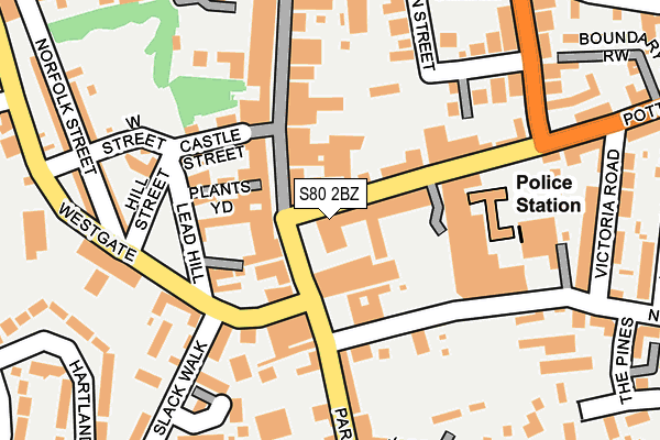
S80 2BZ is located in the Worksop South electoral ward, within the local authority district of Bassetlaw and the English Parliamentary constituency of Bassetlaw. The Sub Integrated Care Board (ICB) Location is NHS Nottingham and Nottinghamshire ICB - 02Q and the police force is Nottinghamshire. This postcode has been in use since September 1981.


GetTheData
Source: OS OpenMap – Local (Ordnance Survey)
Source: OS VectorMap District (Ordnance Survey)
Licence: Open Government Licence (requires attribution)
| Easting | 458479 |
| Northing | 378672 |
| Latitude | 53.301779 |
| Longitude | -1.123961 |
GetTheData
Source: Open Postcode Geo
Licence: Open Government Licence
| Country | England |
| Postcode District | S80 |
| ➜ S80 open data dashboard ➜ See where S80 is on a map ➜ Where is Worksop? | |
GetTheData
Source: Land Registry Price Paid Data
Licence: Open Government Licence
Elevation or altitude of S80 2BZ as distance above sea level:
| Metres | Feet | |
|---|---|---|
| Elevation | 40m | 131ft |
Elevation is measured from the approximate centre of the postcode, to the nearest point on an OS contour line from OS Terrain 50, which has contour spacing of ten vertical metres.
➜ How high above sea level am I? Find the elevation of your current position using your device's GPS.
GetTheData
Source: Open Postcode Elevation
Licence: Open Government Licence
| Ward | Worksop South |
| Constituency | Bassetlaw |
GetTheData
Source: ONS Postcode Database
Licence: Open Government Licence
| November 2023 | Anti-social behaviour | On or near Parking Area | 154m |
| November 2023 | Criminal damage and arson | On or near Parking Area | 154m |
| October 2023 | Violence and sexual offences | On or near Parking Area | 154m |
| ➜ Get more crime data in our Crime section | |||
GetTheData
Source: data.police.uk
Licence: Open Government Licence
| Market Place (Bridge Street) | Worksop | 53m |
| Town Hall (Potter Street) | Worksop | 70m |
| Mayfair Centre (Newgate Street) | Worksop | 110m |
| Westgate | Worksop | 120m |
| Newcastle Avenue | Worksop | 270m |
| Worksop Station | 1.1km |
| Shireoaks Station | 3.9km |
GetTheData
Source: NaPTAN
Licence: Open Government Licence
| Percentage of properties with Next Generation Access | 100.0% |
| Percentage of properties with Superfast Broadband | 100.0% |
| Percentage of properties with Ultrafast Broadband | 100.0% |
| Percentage of properties with Full Fibre Broadband | 0.0% |
Superfast Broadband is between 30Mbps and 300Mbps
Ultrafast Broadband is > 300Mbps
| Percentage of properties unable to receive 2Mbps | 0.0% |
| Percentage of properties unable to receive 5Mbps | 0.0% |
| Percentage of properties unable to receive 10Mbps | 0.0% |
| Percentage of properties unable to receive 30Mbps | 0.0% |
GetTheData
Source: Ofcom
Licence: Ofcom Terms of Use (requires attribution)
GetTheData
Source: ONS Postcode Database
Licence: Open Government Licence


➜ Get more ratings from the Food Standards Agency
GetTheData
Source: Food Standards Agency
Licence: FSA terms & conditions
| Last Collection | |||
|---|---|---|---|
| Location | Mon-Fri | Sat | Distance |
| Potter Street | 17:00 | 11:30 | 41m |
| The Post Office | 18:30 | 12:00 | 243m |
| Hardy Street | 17:00 | 11:00 | 294m |
GetTheData
Source: Dracos
Licence: Creative Commons Attribution-ShareAlike
| Facility | Distance |
|---|---|
| Farr Park Devonshire Street, Worksop Grass Pitches | 363m |
| Worksop Priory C Of E Primary Academy Holles Street, Worksop Grass Pitches | 431m |
| St Annes C E Primary School Harrington Street, Worksop Grass Pitches | 519m |
GetTheData
Source: Active Places
Licence: Open Government Licence
| School | Phase of Education | Distance |
|---|---|---|
| Whitegates College Dukeries Centre, Park Street, Worksop, S80 1HH | Not applicable | 336m |
| Worksop Priory Church of England Primary Academy Holles Street, Worksop, S80 2LJ | Primary | 456m |
| St Anne's CofE (Aided) Primary School Harrington Street, Worksop, S80 1NQ | Primary | 533m |
GetTheData
Source: Edubase
Licence: Open Government Licence
The below table lists the International Territorial Level (ITL) codes (formerly Nomenclature of Territorial Units for Statistics (NUTS) codes) and Local Administrative Units (LAU) codes for S80 2BZ:
| ITL 1 Code | Name |
|---|---|
| TLF | East Midlands (England) |
| ITL 2 Code | Name |
| TLF1 | Derbyshire and Nottinghamshire |
| ITL 3 Code | Name |
| TLF15 | North Nottinghamshire |
| LAU 1 Code | Name |
| E07000171 | Bassetlaw |
GetTheData
Source: ONS Postcode Directory
Licence: Open Government Licence
The below table lists the Census Output Area (OA), Lower Layer Super Output Area (LSOA), and Middle Layer Super Output Area (MSOA) for S80 2BZ:
| Code | Name | |
|---|---|---|
| OA | E00142988 | |
| LSOA | E01028062 | Bassetlaw 013C |
| MSOA | E02005847 | Bassetlaw 013 |
GetTheData
Source: ONS Postcode Directory
Licence: Open Government Licence
| S80 2AD | Potter Street | 24m |
| S80 2AG | Potter Street | 29m |
| S80 1HT | Bridge Street | 60m |
| S80 1DL | Bridge Street | 63m |
| S80 1HZ | Bridge Street | 76m |
| S80 1HR | White Hart Yard | 96m |
| S80 1HY | Plants Yard | 102m |
| S80 1LQ | Castle Street | 115m |
| S80 2AE | Potter Street | 118m |
| S80 1LJ | Lead Hill | 122m |
GetTheData
Source: Open Postcode Geo; Land Registry Price Paid Data
Licence: Open Government Licence