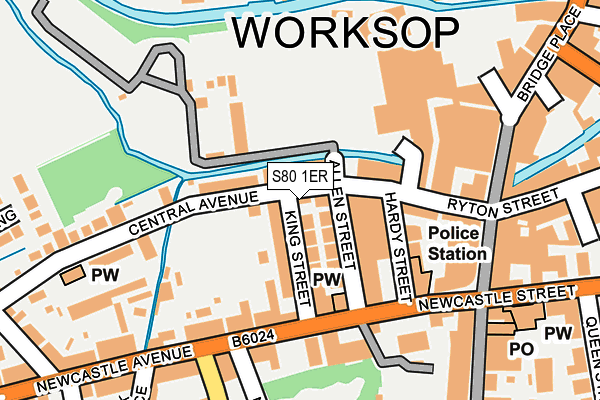
S80 1ER lies on Central Avenue in Worksop. S80 1ER is located in the Worksop South electoral ward, within the local authority district of Bassetlaw and the English Parliamentary constituency of Bassetlaw. The Sub Integrated Care Board (ICB) Location is NHS Nottingham and Nottinghamshire ICB - 02Q and the police force is Nottinghamshire. This postcode has been in use since January 1980.


GetTheData
Source: OS OpenMap – Local (Ordnance Survey)
Source: OS VectorMap District (Ordnance Survey)
Licence: Open Government Licence (requires attribution)
| Easting | 458260 |
| Northing | 379034 |
| Latitude | 53.305057 |
| Longitude | -1.127180 |
GetTheData
Source: Open Postcode Geo
Licence: Open Government Licence
| Street | Central Avenue |
| Town/City | Worksop |
| Country | England |
| Postcode District | S80 |
➜ See where S80 is on a map ➜ Where is Worksop? | |
GetTheData
Source: Land Registry Price Paid Data
Licence: Open Government Licence
Elevation or altitude of S80 1ER as distance above sea level:
| Metres | Feet | |
|---|---|---|
| Elevation | 40m | 131ft |
Elevation is measured from the approximate centre of the postcode, to the nearest point on an OS contour line from OS Terrain 50, which has contour spacing of ten vertical metres.
➜ How high above sea level am I? Find the elevation of your current position using your device's GPS.
GetTheData
Source: Open Postcode Elevation
Licence: Open Government Licence
| Ward | Worksop South |
| Constituency | Bassetlaw |
GetTheData
Source: ONS Postcode Database
Licence: Open Government Licence
| Stagecoach Depot (Hardy Street) | Worksop | 88m |
| Norfolk Street (Newcastle Avenue) | Worksop | 148m |
| Newcastle Avenue | Worksop | 164m |
| Newcastle Avenue | Worksop | 181m |
| Norfolk Street (Newcastle Avenue) | Worksop | 210m |
| Worksop Station | 0.8km |
| Shireoaks Station | 3.5km |
| Whitwell (Derbys) Station | 5.6km |
GetTheData
Source: NaPTAN
Licence: Open Government Licence
| Percentage of properties with Next Generation Access | 100.0% |
| Percentage of properties with Superfast Broadband | 100.0% |
| Percentage of properties with Ultrafast Broadband | 0.0% |
| Percentage of properties with Full Fibre Broadband | 0.0% |
Superfast Broadband is between 30Mbps and 300Mbps
Ultrafast Broadband is > 300Mbps
| Median download speed | 18.9Mbps |
| Average download speed | 23.1Mbps |
| Maximum download speed | 39.06Mbps |
| Median upload speed | 1.1Mbps |
| Average upload speed | 3.9Mbps |
| Maximum upload speed | 9.76Mbps |
| Percentage of properties unable to receive 2Mbps | 0.0% |
| Percentage of properties unable to receive 5Mbps | 0.0% |
| Percentage of properties unable to receive 10Mbps | 0.0% |
| Percentage of properties unable to receive 30Mbps | 0.0% |
GetTheData
Source: Ofcom
Licence: Ofcom Terms of Use (requires attribution)
GetTheData
Source: ONS Postcode Database
Licence: Open Government Licence


➜ Get more ratings from the Food Standards Agency
GetTheData
Source: Food Standards Agency
Licence: FSA terms & conditions
| Last Collection | |||
|---|---|---|---|
| Location | Mon-Fri | Sat | Distance |
| Hardy Street | 17:00 | 11:00 | 141m |
| The Post Office | 18:30 | 12:00 | 212m |
| Ryton Street | 17:30 | 12:00 | 264m |
GetTheData
Source: Dracos
Licence: Creative Commons Attribution-ShareAlike
| Risk of S80 1ER flooding from rivers and sea | Medium |
| ➜ S80 1ER flood map | |
GetTheData
Source: Open Flood Risk by Postcode
Licence: Open Government Licence
The below table lists the International Territorial Level (ITL) codes (formerly Nomenclature of Territorial Units for Statistics (NUTS) codes) and Local Administrative Units (LAU) codes for S80 1ER:
| ITL 1 Code | Name |
|---|---|
| TLF | East Midlands (England) |
| ITL 2 Code | Name |
| TLF1 | Derbyshire and Nottinghamshire |
| ITL 3 Code | Name |
| TLF15 | North Nottinghamshire |
| LAU 1 Code | Name |
| E07000171 | Bassetlaw |
GetTheData
Source: ONS Postcode Directory
Licence: Open Government Licence
The below table lists the Census Output Area (OA), Lower Layer Super Output Area (LSOA), and Middle Layer Super Output Area (MSOA) for S80 1ER:
| Code | Name | |
|---|---|---|
| OA | E00142998 | |
| LSOA | E01028062 | Bassetlaw 013C |
| MSOA | E02005847 | Bassetlaw 013 |
GetTheData
Source: ONS Postcode Directory
Licence: Open Government Licence
| S80 1ES | Allen Street | 56m |
| S80 1EP | King Street | 57m |
| S80 1EL | Central Avenue | 77m |
| S80 1EN | Central Avenue | 101m |
| S80 1ET | Newcastle Avenue | 112m |
| S80 1EH | Hardy Street | 116m |
| S80 1EY | Newcastle Avenue | 151m |
| S80 1EW | Central Avenue | 158m |
| S80 1JR | The Priory Centre | 163m |
| S80 1EU | Newcastle Avenue | 163m |
GetTheData
Source: Open Postcode Geo; Land Registry Price Paid Data
Licence: Open Government Licence