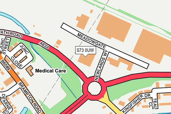
S73 0UW is located in the Wombwell electoral ward, within the metropolitan district of Barnsley and the English Parliamentary constituency of Barnsley East. The Sub Integrated Care Board (ICB) Location is NHS South Yorkshire ICB - 02P and the police force is South Yorkshire. This postcode has been in use since June 1997.


GetTheData
Source: OS OpenMap – Local (Ordnance Survey)
Source: OS VectorMap District (Ordnance Survey)
Licence: Open Government Licence (requires attribution)
| Easting | 441247 |
| Northing | 402358 |
| Latitude | 53.516287 |
| Longitude | -1.379424 |
GetTheData
Source: Open Postcode Geo
Licence: Open Government Licence
| Country | England |
| Postcode District | S73 |
| ➜ S73 open data dashboard ➜ See where S73 is on a map ➜ Where is Wombwell? | |
GetTheData
Source: Land Registry Price Paid Data
Licence: Open Government Licence
Elevation or altitude of S73 0UW as distance above sea level:
| Metres | Feet | |
|---|---|---|
| Elevation | 30m | 98ft |
Elevation is measured from the approximate centre of the postcode, to the nearest point on an OS contour line from OS Terrain 50, which has contour spacing of ten vertical metres.
➜ How high above sea level am I? Find the elevation of your current position using your device's GPS.
GetTheData
Source: Open Postcode Elevation
Licence: Open Government Licence
| Ward | Wombwell |
| Constituency | Barnsley East |
GetTheData
Source: ONS Postcode Database
Licence: Open Government Licence
| September 2023 | Burglary | On or near Spring Drive | 445m |
| September 2023 | Burglary | On or near Spring Drive | 445m |
| July 2023 | Vehicle crime | On or near Spring Drive | 445m |
| ➜ Get more crime data in our Crime section | |||
GetTheData
Source: data.police.uk
Licence: Open Government Licence
| Junction Street (Brampton Road) | Wombwell | 264m |
| Kingfisher Drive (Wath Road) | Brampton | 279m |
| Brierlow Close (Knollbeck Lane) | Brampton | 331m |
| Junction Street (Brampton Road) | Wombwell | 331m |
| Chapel Avenue (Wath Road) | Brampton | 335m |
| Wombwell Station | 2.4km |
| Elsecar Station | 3.7km |
| Bolton-Upon-Dearne Station | 4.5km |
GetTheData
Source: NaPTAN
Licence: Open Government Licence
GetTheData
Source: ONS Postcode Database
Licence: Open Government Licence


➜ Get more ratings from the Food Standards Agency
GetTheData
Source: Food Standards Agency
Licence: FSA terms & conditions
| Last Collection | |||
|---|---|---|---|
| Location | Mon-Fri | Sat | Distance |
| Brampton Road | 17:10 | 11:00 | 284m |
| Post Office | 17:10 | 11:15 | 454m |
| Lundhill Road | 17:10 | 11:00 | 651m |
GetTheData
Source: Dracos
Licence: Creative Commons Attribution-ShareAlike
| Facility | Distance |
|---|---|
| Brampton Bierlow Park Wath Road, Brampton Bierlow, Rotherham Grass Pitches, Cycling | 463m |
| Cortonwood Miners Welfare Scheme Knollbeck Lane, Brampton, Barnsley Grass Pitches | 796m |
| Wombwell Park Street Primary School Park Street, Wombwell, Barnsley Grass Pitches | 1km |
GetTheData
Source: Active Places
Licence: Open Government Licence
| School | Phase of Education | Distance |
|---|---|---|
| Brampton Cortonwood Infant School Chapel Avenue, Brampton Bierlow, Barnsley, S73 0XH | Primary | 503m |
| Wombwell Park Street Primary School Park Street, Wombwell, Barnsley, S73 0HS | Primary | 973m |
| St Michael and All Angels Catholic Primary School Stonyford Road, Wombwell, Barnsley, S73 8AF | Primary | 1.4km |
GetTheData
Source: Edubase
Licence: Open Government Licence
The below table lists the International Territorial Level (ITL) codes (formerly Nomenclature of Territorial Units for Statistics (NUTS) codes) and Local Administrative Units (LAU) codes for S73 0UW:
| ITL 1 Code | Name |
|---|---|
| TLE | Yorkshire and The Humber |
| ITL 2 Code | Name |
| TLE3 | South Yorkshire |
| ITL 3 Code | Name |
| TLE31 | Barnsley, Doncaster and Rotherham |
| LAU 1 Code | Name |
| E08000016 | Barnsley |
GetTheData
Source: ONS Postcode Directory
Licence: Open Government Licence
The below table lists the Census Output Area (OA), Lower Layer Super Output Area (LSOA), and Middle Layer Super Output Area (MSOA) for S73 0UW:
| Code | Name | |
|---|---|---|
| OA | E00037772 | |
| LSOA | E01032925 | Barnsley 026G |
| MSOA | E02001534 | Barnsley 026 |
GetTheData
Source: ONS Postcode Directory
Licence: Open Government Licence
| S73 0UN | Meadow Gate | 143m |
| S73 0UU | Grebe Court | 205m |
| S73 0SQ | Junction Close | 234m |
| S73 0SS | Brampton Road | 244m |
| S73 0QY | Brampton Road | 250m |
| S73 0YD | Navigation Way | 290m |
| S73 0US | Teal Close | 291m |
| S73 0XB | Wath Road | 316m |
| S73 0NY | Croft Close | 330m |
| S73 0NZ | Eastwell Grove | 332m |
GetTheData
Source: Open Postcode Geo; Land Registry Price Paid Data
Licence: Open Government Licence