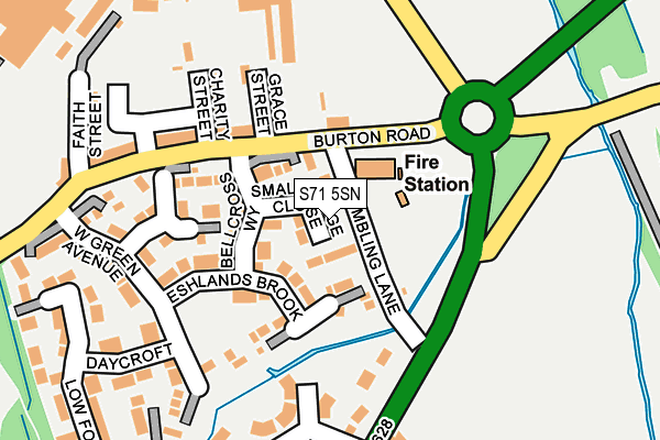
S71 5SN is located in the Cudworth electoral ward, within the metropolitan district of Barnsley and the English Parliamentary constituency of Barnsley East. The Sub Integrated Care Board (ICB) Location is NHS South Yorkshire ICB - 02P and the police force is South Yorkshire. This postcode has been in use since June 2015.


GetTheData
Source: OS OpenMap – Local (Ordnance Survey)
Source: OS VectorMap District (Ordnance Survey)
Licence: Open Government Licence (requires attribution)
| Easting | 437814 |
| Northing | 408523 |
| Latitude | 53.571955 |
| Longitude | -1.430451 |
GetTheData
Source: Open Postcode Geo
Licence: Open Government Licence
| Country | England |
| Postcode District | S71 |
| ➜ S71 open data dashboard ➜ See where S71 is on a map | |
GetTheData
Source: Land Registry Price Paid Data
Licence: Open Government Licence
Elevation or altitude of S71 5SN as distance above sea level:
| Metres | Feet | |
|---|---|---|
| Elevation | 40m | 131ft |
Elevation is measured from the approximate centre of the postcode, to the nearest point on an OS contour line from OS Terrain 50, which has contour spacing of ten vertical metres.
➜ How high above sea level am I? Find the elevation of your current position using your device's GPS.
GetTheData
Source: Open Postcode Elevation
Licence: Open Government Licence
| Ward | Cudworth |
| Constituency | Barnsley East |
GetTheData
Source: ONS Postcode Database
Licence: Open Government Licence
| December 2023 | Violence and sexual offences | On or near Parkland View | 367m |
| November 2023 | Vehicle crime | On or near Parkland View | 367m |
| October 2023 | Anti-social behaviour | On or near Parkland View | 367m |
| ➜ Get more crime data in our Crime section | |||
GetTheData
Source: data.police.uk
Licence: Open Government Licence
| Charity Street (Burton Road) | West Green | 150m |
| Hope Street (Burton Road) | West Green | 205m |
| Station Road (Pontefract Road) | Lundwood | 293m |
| Burton Road (Barnsley Road) | Cudworth | 393m |
| Station Road (Pontefract Road) | Lundwood | 438m |
| Barnsley Station | 3.7km |
GetTheData
Source: NaPTAN
Licence: Open Government Licence
GetTheData
Source: ONS Postcode Database
Licence: Open Government Licence


➜ Get more ratings from the Food Standards Agency
GetTheData
Source: Food Standards Agency
Licence: FSA terms & conditions
| Last Collection | |||
|---|---|---|---|
| Location | Mon-Fri | Sat | Distance |
| Burton Road | 16:45 | 11:00 | 222m |
| Station Road | 16:00 | 09:00 | 442m |
| Manor Road | 16:00 | 11:45 | 790m |
GetTheData
Source: Dracos
Licence: Creative Commons Attribution-ShareAlike
| Facility | Distance |
|---|---|
| Valley Community Centre Manor Road, Cudworth, Barnsley Sports Hall | 682m |
| Be Fitness (Closed) Barnsley Road, Cudworth, Barnsley Health and Fitness Gym | 941m |
| Cudworth Park (Closed) Rose Tree Avenue, Cudworth, Barnsley Grass Pitches | 1.1km |
GetTheData
Source: Active Places
Licence: Open Government Licence
| School | Phase of Education | Distance |
|---|---|---|
| St Helen's Primary Academy St Helen's Way, Monk Bretton, Barnsley, S71 2PS | Primary | 1.1km |
| Churchfield Primary School Snydale Road, Cudworth, Barnsley, S72 8JR | Primary | 1.2km |
| Birkwood Primary School Darfield Road, Cudworth, Barnsley, S72 8HG | Primary | 1.5km |
GetTheData
Source: Edubase
Licence: Open Government Licence
The below table lists the International Territorial Level (ITL) codes (formerly Nomenclature of Territorial Units for Statistics (NUTS) codes) and Local Administrative Units (LAU) codes for S71 5SN:
| ITL 1 Code | Name |
|---|---|
| TLE | Yorkshire and The Humber |
| ITL 2 Code | Name |
| TLE3 | South Yorkshire |
| ITL 3 Code | Name |
| TLE31 | Barnsley, Doncaster and Rotherham |
| LAU 1 Code | Name |
| E08000016 | Barnsley |
GetTheData
Source: ONS Postcode Directory
Licence: Open Government Licence
The below table lists the Census Output Area (OA), Lower Layer Super Output Area (LSOA), and Middle Layer Super Output Area (MSOA) for S71 5SN:
| Code | Name | |
|---|---|---|
| OA | E00168690 | |
| LSOA | E01007344 | Barnsley 011A |
| MSOA | E02001519 | Barnsley 011 |
GetTheData
Source: ONS Postcode Directory
Licence: Open Government Licence
| S71 5SL | Small Bridge Close | 30m |
| S71 5SJ | Bellcross Way | 87m |
| S71 5SH | Eshlands Brook | 93m |
| S71 5SF | Kingwood Close | 134m |
| S71 5RZ | Grace Street | 152m |
| S71 5RU | Burton Road | 160m |
| S71 5LJ | Valley Grove | 175m |
| S71 5SG | West Green Avenue | 195m |
| S71 5SE | Daycroft | 231m |
| S71 5RT | Faith Street | 233m |
GetTheData
Source: Open Postcode Geo; Land Registry Price Paid Data
Licence: Open Government Licence