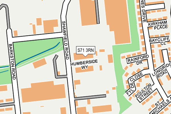
S71 3RN is located in the Monk Bretton electoral ward, within the metropolitan district of Barnsley and the English Parliamentary constituency of Barnsley Central. The Sub Integrated Care Board (ICB) Location is NHS South Yorkshire ICB - 02P and the police force is South Yorkshire. This postcode has been in use since March 1983.


GetTheData
Source: OS OpenMap – Local (Ordnance Survey)
Source: OS VectorMap District (Ordnance Survey)
Licence: Open Government Licence (requires attribution)
| Easting | 436560 |
| Northing | 408938 |
| Latitude | 53.575774 |
| Longitude | -1.449338 |
GetTheData
Source: Open Postcode Geo
Licence: Open Government Licence
| Country | England |
| Postcode District | S71 |
| ➜ S71 open data dashboard ➜ See where S71 is on a map ➜ Where is Carlton? | |
GetTheData
Source: Land Registry Price Paid Data
Licence: Open Government Licence
Elevation or altitude of S71 3RN as distance above sea level:
| Metres | Feet | |
|---|---|---|
| Elevation | 60m | 197ft |
Elevation is measured from the approximate centre of the postcode, to the nearest point on an OS contour line from OS Terrain 50, which has contour spacing of ten vertical metres.
➜ How high above sea level am I? Find the elevation of your current position using your device's GPS.
GetTheData
Source: Open Postcode Elevation
Licence: Open Government Licence
| Ward | Monk Bretton |
| Constituency | Barnsley Central |
GetTheData
Source: ONS Postcode Database
Licence: Open Government Licence
| June 2022 | Burglary | On or near Humberside Way | 22m |
| June 2022 | Criminal damage and arson | On or near Humberside Way | 22m |
| June 2022 | Other theft | On or near Humberside Way | 22m |
| ➜ Get more crime data in our Crime section | |||
GetTheData
Source: data.police.uk
Licence: Open Government Licence
| Kirkham Place (Fish Dam Lane) | Monk Bretton | 323m |
| Baycliff Close (Fish Dam Lane) | Monk Bretton | 331m |
| Albion Road (Industry Road) | Carlton | 429m |
| Preston Way (Fish Dam Lane) | Monk Bretton | 464m |
| Preston Way (Fish Dam Lane) | Monk Bretton | 499m |
| Barnsley Station | 3km |
GetTheData
Source: NaPTAN
Licence: Open Government Licence
GetTheData
Source: ONS Postcode Database
Licence: Open Government Licence

➜ Get more ratings from the Food Standards Agency
GetTheData
Source: Food Standards Agency
Licence: FSA terms & conditions
| Last Collection | |||
|---|---|---|---|
| Location | Mon-Fri | Sat | Distance |
| Industry Road | 18:30 | 436m | |
| 13 King Edward Street | 17:00 | 10:30 | 537m |
| Fish Dam Lane | 17:00 | 11:00 | 803m |
GetTheData
Source: Dracos
Licence: Creative Commons Attribution-ShareAlike
| Facility | Distance |
|---|---|
| St Dominic's Catholic Primary School (Closed) Carlton Road, Barnsley Grass Pitches | 553m |
| St Helens Primary (Closed) St. Helens Way, Barnsley Grass Pitches | 564m |
| St Michael's Catholic & Church Of England High School (Closed) Carlton Road, Barnsley Grass Pitches, Sports Hall | 631m |
GetTheData
Source: Active Places
Licence: Open Government Licence
| School | Phase of Education | Distance |
|---|---|---|
| St Helen's Primary Academy St Helen's Way, Monk Bretton, Barnsley, S71 2PS | Primary | 564m |
| Holy Trinity Catholic and Church of England School Carlton Road, Barnsley, S71 2LF | All-through | 631m |
| Springwell Special Academy St Helen's Boulevard, Carlton Road, Barnsley, S71 2AY | Not applicable | 811m |
GetTheData
Source: Edubase
Licence: Open Government Licence
The below table lists the International Territorial Level (ITL) codes (formerly Nomenclature of Territorial Units for Statistics (NUTS) codes) and Local Administrative Units (LAU) codes for S71 3RN:
| ITL 1 Code | Name |
|---|---|
| TLE | Yorkshire and The Humber |
| ITL 2 Code | Name |
| TLE3 | South Yorkshire |
| ITL 3 Code | Name |
| TLE31 | Barnsley, Doncaster and Rotherham |
| LAU 1 Code | Name |
| E08000016 | Barnsley |
GetTheData
Source: ONS Postcode Directory
Licence: Open Government Licence
The below table lists the Census Output Area (OA), Lower Layer Super Output Area (LSOA), and Middle Layer Super Output Area (MSOA) for S71 3RN:
| Code | Name | |
|---|---|---|
| OA | E00037532 | |
| LSOA | E01007406 | Barnsley 009E |
| MSOA | E02001517 | Barnsley 009 |
GetTheData
Source: ONS Postcode Directory
Licence: Open Government Licence
| S71 2SF | Rainford Drive | 163m |
| S71 2SN | Fylde Close | 206m |
| S71 2SA | St Annes Drive | 221m |
| S71 2SB | St Annes Drive | 238m |
| S71 2SG | Edenfield Close | 266m |
| S71 2SE | Poulton Street | 267m |
| S71 2SQ | Baycliff Close | 276m |
| S71 2SH | Kirkham Place | 279m |
| S71 2SL | St Francis Boulevard | 320m |
| S71 2SD | St Michaels Avenue | 342m |
GetTheData
Source: Open Postcode Geo; Land Registry Price Paid Data
Licence: Open Government Licence