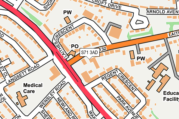
S71 3AD is located in the St Helens electoral ward, within the metropolitan district of Barnsley and the English Parliamentary constituency of Barnsley Central. The Sub Integrated Care Board (ICB) Location is NHS South Yorkshire ICB - 02P and the police force is South Yorkshire. This postcode has been in use since August 2005.


GetTheData
Source: OS OpenMap – Local (Ordnance Survey)
Source: OS VectorMap District (Ordnance Survey)
Licence: Open Government Licence (requires attribution)
| Easting | 434572 |
| Northing | 409314 |
| Latitude | 53.579305 |
| Longitude | -1.479320 |
GetTheData
Source: Open Postcode Geo
Licence: Open Government Licence
| Country | England |
| Postcode District | S71 |
| ➜ S71 open data dashboard ➜ See where S71 is on a map ➜ Where is Barnsley? | |
GetTheData
Source: Land Registry Price Paid Data
Licence: Open Government Licence
Elevation or altitude of S71 3AD as distance above sea level:
| Metres | Feet | |
|---|---|---|
| Elevation | 90m | 295ft |
Elevation is measured from the approximate centre of the postcode, to the nearest point on an OS contour line from OS Terrain 50, which has contour spacing of ten vertical metres.
➜ How high above sea level am I? Find the elevation of your current position using your device's GPS.
GetTheData
Source: Open Postcode Elevation
Licence: Open Government Licence
| Ward | St Helens |
| Constituency | Barnsley Central |
GetTheData
Source: ONS Postcode Database
Licence: Open Government Licence
| January 2024 | Violence and sexual offences | On or near Forest Road | 420m |
| December 2023 | Violence and sexual offences | On or near Forest Road | 420m |
| December 2023 | Other crime | On or near Forest Road | 420m |
| ➜ Get more crime data in our Crime section | |||
GetTheData
Source: data.police.uk
Licence: Open Government Licence
| Roundhouse (Laithes Lane) | New Lodge | 40m |
| Laithes Lane (Wakefield Road) | New Lodge | 56m |
| Laithes Crescent (Laithes Lane) | New Lodge | 67m |
| Langsett Road (Wakefield Road) | New Lodge | 118m |
| Laithes Crescent (Laithes Lane) | Athersley South | 145m |
| Barnsley Station | 2.8km |
| Darton Station | 3.6km |
| Dodworth Station | 5.2km |
GetTheData
Source: NaPTAN
Licence: Open Government Licence
GetTheData
Source: ONS Postcode Database
Licence: Open Government Licence

➜ Get more ratings from the Food Standards Agency
GetTheData
Source: Food Standards Agency
Licence: FSA terms & conditions
| Last Collection | |||
|---|---|---|---|
| Location | Mon-Fri | Sat | Distance |
| New Lodge Estate Post Office | 17:10 | 11:30 | 79m |
| New Lodge Crescent | 16:40 | 11:00 | 189m |
| New Lodge Crescent | 16:40 | 11:30 | 379m |
GetTheData
Source: Dracos
Licence: Creative Commons Attribution-ShareAlike
| Facility | Distance |
|---|---|
| St Helens Church Hall Laithes Lane, Athersley South, Barnsley Sports Hall | 157m |
| Laithes Primary School Laithes Lane, Barnsley Grass Pitches | 243m |
| Athersley South Primary School Wakefield Road, Barnsley Grass Pitches | 421m |
GetTheData
Source: Active Places
Licence: Open Government Licence
| School | Phase of Education | Distance |
|---|---|---|
| Laithes Primary School Laithes Lane, Smithies, Barnsley, S71 3AF | Primary | 252m |
| Athersley South Primary School Wakefield Road, Smithies, Barnsley, S71 3TP | Primary | 418m |
| Athersley North Primary School Lindhurst Road, Athersley North, Barnsley, S71 3NB | Primary | 589m |
GetTheData
Source: Edubase
Licence: Open Government Licence
The below table lists the International Territorial Level (ITL) codes (formerly Nomenclature of Territorial Units for Statistics (NUTS) codes) and Local Administrative Units (LAU) codes for S71 3AD:
| ITL 1 Code | Name |
|---|---|
| TLE | Yorkshire and The Humber |
| ITL 2 Code | Name |
| TLE3 | South Yorkshire |
| ITL 3 Code | Name |
| TLE31 | Barnsley, Doncaster and Rotherham |
| LAU 1 Code | Name |
| E08000016 | Barnsley |
GetTheData
Source: ONS Postcode Directory
Licence: Open Government Licence
The below table lists the Census Output Area (OA), Lower Layer Super Output Area (LSOA), and Middle Layer Super Output Area (MSOA) for S71 3AD:
| Code | Name | |
|---|---|---|
| OA | E00037132 | |
| LSOA | E01007324 | Barnsley 007B |
| MSOA | E02001515 | Barnsley 007 |
GetTheData
Source: ONS Postcode Directory
Licence: Open Government Licence
| S71 3AB | Laithes Lane | 56m |
| S71 3LR | Wakefield Road | 77m |
| S71 3AA | Laithes Lane | 93m |
| S71 1TH | Wakefield Road | 121m |
| S71 3AE | Laithes Crescent | 125m |
| S71 3TX | Wakefield Road | 151m |
| S71 3TS | Regent Crescent | 154m |
| S71 3TT | Park Avenue | 155m |
| S71 1TQ | Newland Road | 157m |
| S71 1TJ | Wensley Road | 175m |
GetTheData
Source: Open Postcode Geo; Land Registry Price Paid Data
Licence: Open Government Licence