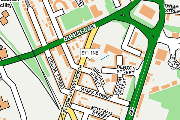
S71 1NB is located in the Central electoral ward, within the metropolitan district of Barnsley and the English Parliamentary constituency of Barnsley Central. The Sub Integrated Care Board (ICB) Location is NHS South Yorkshire ICB - 02P and the police force is South Yorkshire. This postcode has been in use since January 1980.


GetTheData
Source: OS OpenMap – Local (Ordnance Survey)
Source: OS VectorMap District (Ordnance Survey)
Licence: Open Government Licence (requires attribution)
| Easting | 434795 |
| Northing | 406897 |
| Latitude | 53.557549 |
| Longitude | -1.476219 |
GetTheData
Source: Open Postcode Geo
Licence: Open Government Licence
| Country | England |
| Postcode District | S71 |
| ➜ S71 open data dashboard ➜ See where S71 is on a map ➜ Where is Barnsley? | |
GetTheData
Source: Land Registry Price Paid Data
Licence: Open Government Licence
Elevation or altitude of S71 1NB as distance above sea level:
| Metres | Feet | |
|---|---|---|
| Elevation | 70m | 230ft |
Elevation is measured from the approximate centre of the postcode, to the nearest point on an OS contour line from OS Terrain 50, which has contour spacing of ten vertical metres.
➜ How high above sea level am I? Find the elevation of your current position using your device's GPS.
GetTheData
Source: Open Postcode Elevation
Licence: Open Government Licence
| Ward | Central |
| Constituency | Barnsley Central |
GetTheData
Source: ONS Postcode Database
Licence: Open Government Licence
| January 2024 | Criminal damage and arson | On or near Twibell Street | 393m |
| January 2024 | Anti-social behaviour | On or near Hanson Street | 489m |
| January 2024 | Anti-social behaviour | On or near Hanson Street | 489m |
| ➜ Get more crime data in our Crime section | |||
GetTheData
Source: data.police.uk
Licence: Open Government Licence
| Beckett Street (Eldon Street North) | Barnsley Town Centre | 64m |
| Bridge Street (Eldon Street North) | Barnsley Town Centre | 113m |
| Leighton Close (Honeywell Street) | Honeywell | 202m |
| Leighton Close (Honeywell Street) | Honeywell | 226m |
| Old Mill Bridge (Harbrough Hill Road) | Barnsley Town Centre | 335m |
| Barnsley Station | 0.4km |
| Dodworth Station | 4km |
| Darton Station | 5km |
GetTheData
Source: NaPTAN
Licence: Open Government Licence
| Percentage of properties with Next Generation Access | 100.0% |
| Percentage of properties with Superfast Broadband | 100.0% |
| Percentage of properties with Ultrafast Broadband | 100.0% |
| Percentage of properties with Full Fibre Broadband | 0.0% |
Superfast Broadband is between 30Mbps and 300Mbps
Ultrafast Broadband is > 300Mbps
| Percentage of properties unable to receive 2Mbps | 0.0% |
| Percentage of properties unable to receive 5Mbps | 0.0% |
| Percentage of properties unable to receive 10Mbps | 0.0% |
| Percentage of properties unable to receive 30Mbps | 0.0% |
GetTheData
Source: Ofcom
Licence: Ofcom Terms of Use (requires attribution)
GetTheData
Source: ONS Postcode Database
Licence: Open Government Licence


➜ Get more ratings from the Food Standards Agency
GetTheData
Source: Food Standards Agency
Licence: FSA terms & conditions
| Last Collection | |||
|---|---|---|---|
| Location | Mon-Fri | Sat | Distance |
| Post Office | 16:00 | 11:00 | 51m |
| Asda Stores | 16:00 | 11:00 | 328m |
| Technical College | 18:45 | 11:30 | 461m |
GetTheData
Source: Dracos
Licence: Creative Commons Attribution-ShareAlike
| Facility | Distance |
|---|---|
| Keel Fitness Centre (Closed) Canal Street, Barnsley Health and Fitness Gym, Studio | 163m |
| Queens Road Academy Queens Road, Barnsley Grass Pitches | 377m |
| Jd Gyms (Barnsley) Twibell Street, Barnsley Health and Fitness Gym | 388m |
GetTheData
Source: Active Places
Licence: Open Government Licence
| School | Phase of Education | Distance |
|---|---|---|
| Trinity Academy St. Edwards 9 Eastgate, Barnsley, S70 2EX | Secondary | 433m |
| Queens Road Academy Queens Road, Barnsley, S71 1AR | Primary | 483m |
| Barnsley College PO Box 266, Church Street, Barnsley, S70 2YW | 16 plus | 769m |
GetTheData
Source: Edubase
Licence: Open Government Licence
The below table lists the International Territorial Level (ITL) codes (formerly Nomenclature of Territorial Units for Statistics (NUTS) codes) and Local Administrative Units (LAU) codes for S71 1NB:
| ITL 1 Code | Name |
|---|---|
| TLE | Yorkshire and The Humber |
| ITL 2 Code | Name |
| TLE3 | South Yorkshire |
| ITL 3 Code | Name |
| TLE31 | Barnsley, Doncaster and Rotherham |
| LAU 1 Code | Name |
| E08000016 | Barnsley |
GetTheData
Source: ONS Postcode Directory
Licence: Open Government Licence
The below table lists the Census Output Area (OA), Lower Layer Super Output Area (LSOA), and Middle Layer Super Output Area (MSOA) for S71 1NB:
| Code | Name | |
|---|---|---|
| OA | E00037174 | |
| LSOA | E01007336 | Barnsley 013A |
| MSOA | E02001521 | Barnsley 013 |
GetTheData
Source: ONS Postcode Directory
Licence: Open Government Licence
| S71 1LQ | Eldon Street North | 37m |
| S71 1BN | Beckett Street | 59m |
| S71 1PR | Honeywell Street | 64m |
| S71 1PT | Kaye Street | 70m |
| S71 1DB | Vernon Street North | 87m |
| S71 1LG | Eldon Street North | 109m |
| S71 1LF | Eldon Street North | 109m |
| S71 1PS | Old Mill Lane | 111m |
| S71 1DA | Denton Street | 111m |
| S71 1LH | Old Mill Lane | 125m |
GetTheData
Source: Open Postcode Geo; Land Registry Price Paid Data
Licence: Open Government Licence