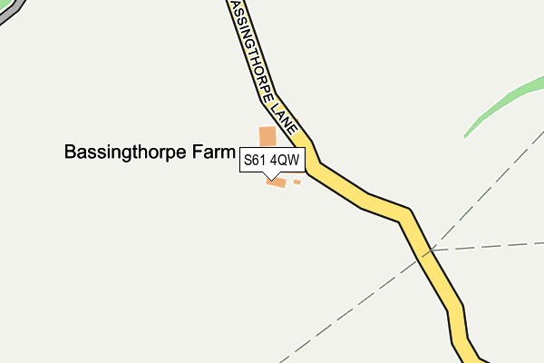
S61 4QW is located in the Greasbrough electoral ward, within the metropolitan district of Rotherham and the English Parliamentary constituency of Rotherham. The Sub Integrated Care Board (ICB) Location is NHS South Yorkshire ICB - 03L and the police force is South Yorkshire. This postcode has been in use since January 1980.


GetTheData
Source: OS OpenMap – Local (Ordnance Survey)
Source: OS VectorMap District (Ordnance Survey)
Licence: Open Government Licence (requires attribution)
| Easting | 441719 |
| Northing | 394273 |
| Latitude | 53.443583 |
| Longitude | -1.373378 |
GetTheData
Source: Open Postcode Geo
Licence: Open Government Licence
| Country | England |
| Postcode District | S61 |
| ➜ S61 open data dashboard ➜ See where S61 is on a map | |
GetTheData
Source: Land Registry Price Paid Data
Licence: Open Government Licence
Elevation or altitude of S61 4QW as distance above sea level:
| Metres | Feet | |
|---|---|---|
| Elevation | 80m | 262ft |
Elevation is measured from the approximate centre of the postcode, to the nearest point on an OS contour line from OS Terrain 50, which has contour spacing of ten vertical metres.
➜ How high above sea level am I? Find the elevation of your current position using your device's GPS.
GetTheData
Source: Open Postcode Elevation
Licence: Open Government Licence
| Ward | Greasbrough |
| Constituency | Rotherham |
GetTheData
Source: ONS Postcode Database
Licence: Open Government Licence
| May 2022 | Violence and sexual offences | On or near Sports/Recreation Area | 324m |
| May 2022 | Other theft | On or near Broom Riddings | 438m |
| April 2022 | Anti-social behaviour | On or near Broom Riddings | 438m |
| ➜ Get more crime data in our Crime section | |||
GetTheData
Source: data.police.uk
Licence: Open Government Licence
| Hudsons Rough (Fenton Road) | Kimberworth Park | 547m |
| Hudsons Rough (Fenton Road) | Kimberworth Park | 568m |
| Coppice Gardens (Wagon Road) | Munsbrough | 609m |
| Acorn Croft (Wagon Road) | Munsbrough | 624m |
| Ryeview Gardens (Wagon Road) | Munsbrough | 643m |
| Rotherham Central Station | 1.5km |
| Meadowhall Station | 3.9km |
| Swinton (South Yorks) Station | 6.5km |
GetTheData
Source: NaPTAN
Licence: Open Government Licence
| Percentage of properties with Next Generation Access | 100.0% |
| Percentage of properties with Superfast Broadband | 0.0% |
| Percentage of properties with Ultrafast Broadband | 0.0% |
| Percentage of properties with Full Fibre Broadband | 0.0% |
Superfast Broadband is between 30Mbps and 300Mbps
Ultrafast Broadband is > 300Mbps
| Percentage of properties unable to receive 2Mbps | 0.0% |
| Percentage of properties unable to receive 5Mbps | 0.0% |
| Percentage of properties unable to receive 10Mbps | 0.0% |
| Percentage of properties unable to receive 30Mbps | 100.0% |
GetTheData
Source: Ofcom
Licence: Ofcom Terms of Use (requires attribution)
GetTheData
Source: ONS Postcode Database
Licence: Open Government Licence


➜ Get more ratings from the Food Standards Agency
GetTheData
Source: Food Standards Agency
Licence: FSA terms & conditions
| Last Collection | |||
|---|---|---|---|
| Location | Mon-Fri | Sat | Distance |
| 18 Broom Riddings | 16:15 | 12:15 | 443m |
| Fenton Fields | 16:00 | 11:30 | 828m |
| 33 Roughwood Road | 16:00 | 12:00 | 870m |
GetTheData
Source: Dracos
Licence: Creative Commons Attribution-ShareAlike
| Facility | Distance |
|---|---|
| Wingfield Academy Wingfield Road, Rotherham Grass Pitches, Health and Fitness Gym, Sports Hall, Outdoor Tennis Courts | 868m |
| Wingfield Pool (Closed) Wingfield Road, Rotherham Swimming Pool | 925m |
| Greasbrough Primary School Munsbrough Rise, Rotherham Grass Pitches | 1km |
GetTheData
Source: Active Places
Licence: Open Government Licence
| School | Phase of Education | Distance |
|---|---|---|
| Wingfield Academy Wingfield Road, Rotherham, S61 4AU | Secondary | 863m |
| Thornhill Primary School Clough Bank, Rotherham, S61 1TD | Primary | 1km |
| Greasbrough Primary School Munsbrough Rise, Greasbrough, Rotherham, S61 4RB | Primary | 1km |
GetTheData
Source: Edubase
Licence: Open Government Licence
The below table lists the International Territorial Level (ITL) codes (formerly Nomenclature of Territorial Units for Statistics (NUTS) codes) and Local Administrative Units (LAU) codes for S61 4QW:
| ITL 1 Code | Name |
|---|---|
| TLE | Yorkshire and The Humber |
| ITL 2 Code | Name |
| TLE3 | South Yorkshire |
| ITL 3 Code | Name |
| TLE31 | Barnsley, Doncaster and Rotherham |
| LAU 1 Code | Name |
| E08000018 | Rotherham |
GetTheData
Source: ONS Postcode Directory
Licence: Open Government Licence
The below table lists the Census Output Area (OA), Lower Layer Super Output Area (LSOA), and Middle Layer Super Output Area (MSOA) for S61 4QW:
| Code | Name | |
|---|---|---|
| OA | E00039171 | |
| LSOA | E01007728 | Rotherham 009A |
| MSOA | E02001586 | Rotherham 009 |
GetTheData
Source: ONS Postcode Directory
Licence: Open Government Licence
| S61 4NR | Broom Riddings | 489m |
| S61 4RE | Coppice Gardens | 535m |
| S61 4QG | Fenton Way | 612m |
| S61 4NT | Munsbrough Lane | 654m |
| S61 4RH | Ryeview Gardens | 656m |
| S61 4RG | Ashleigh Gardens | 659m |
| S61 3EF | Simmonite Road | 683m |
| S61 4NW | Acorn Croft | 713m |
| S61 3SU | Fenton Fields | 723m |
| S61 3RH | Ten Acre Road | 725m |
GetTheData
Source: Open Postcode Geo; Land Registry Price Paid Data
Licence: Open Government Licence