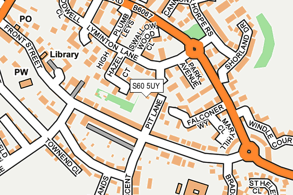
S60 5UY is located in the Rother Vale electoral ward, within the metropolitan district of Rotherham and the English Parliamentary constituency of Rother Valley. The Sub Integrated Care Board (ICB) Location is NHS South Yorkshire ICB - 03L and the police force is South Yorkshire. This postcode has been in use since August 2016.


GetTheData
Source: OS OpenMap – Local (Ordnance Survey)
Source: OS VectorMap District (Ordnance Survey)
Licence: Open Government Licence (requires attribution)
| Easting | 443513 |
| Northing | 387694 |
| Latitude | 53.384325 |
| Longitude | -1.347276 |
GetTheData
Source: Open Postcode Geo
Licence: Open Government Licence
| Country | England |
| Postcode District | S60 |
| ➜ S60 open data dashboard ➜ See where S60 is on a map ➜ Where is Treeton? | |
GetTheData
Source: Land Registry Price Paid Data
Licence: Open Government Licence
Elevation or altitude of S60 5UY as distance above sea level:
| Metres | Feet | |
|---|---|---|
| Elevation | 60m | 197ft |
Elevation is measured from the approximate centre of the postcode, to the nearest point on an OS contour line from OS Terrain 50, which has contour spacing of ten vertical metres.
➜ How high above sea level am I? Find the elevation of your current position using your device's GPS.
GetTheData
Source: Open Postcode Elevation
Licence: Open Government Licence
| Ward | Rother Vale |
| Constituency | Rother Valley |
GetTheData
Source: ONS Postcode Database
Licence: Open Government Licence
| December 2023 | Vehicle crime | On or near Cannonthorpe Rise | 185m |
| December 2023 | Vehicle crime | On or near Cannonthorpe Rise | 185m |
| December 2023 | Vehicle crime | On or near Cannonthorpe Rise | 185m |
| ➜ Get more crime data in our Crime section | |||
GetTheData
Source: data.police.uk
Licence: Open Government Licence
| Pit Lane (Wood Lane) | Treeton | 93m |
| Pit Lane (Wood Lane) | Treeton | 117m |
| Falconer Way (High Hazel Road) | Treeton | 125m |
| Lyminton Lane (High Hazel Road) | Treeton | 127m |
| Shorland Drive (High Hazel Road) | Treeton | 150m |
| Woodhouse Station | 2.4km |
| Darnall Station | 4.3km |
| Meadowhall Station | 5.7km |
GetTheData
Source: NaPTAN
Licence: Open Government Licence
GetTheData
Source: ONS Postcode Database
Licence: Open Government Licence


➜ Get more ratings from the Food Standards Agency
GetTheData
Source: Food Standards Agency
Licence: FSA terms & conditions
| Last Collection | |||
|---|---|---|---|
| Location | Mon-Fri | Sat | Distance |
| Treeton Post Office | 17:00 | 12:00 | 301m |
| Station Road | 16:00 | 10:30 | 550m |
| 22 Bole Hill | 16:45 | 12:00 | 602m |
GetTheData
Source: Dracos
Licence: Creative Commons Attribution-ShareAlike
| Facility | Distance |
|---|---|
| Treeton Community Centre Pit Lane, Pit Lane, Treeton, Rotherham Sports Hall | 19m |
| Treeton C Of E Primary School Wood Lane, Treeton, Rotherham Grass Pitches | 227m |
| Treeton Memorial Playing Field Washfield Lane, Treeton, Rotherham Grass Pitches | 407m |
GetTheData
Source: Active Places
Licence: Open Government Licence
| School | Phase of Education | Distance |
|---|---|---|
| Treeton Church of England Primary School Wood Lane, Treeton, Rotherham, S60 5QS | Primary | 228m |
| Catcliffe Primary School Rotherham Road, Catcliffe, Rotherham, S60 5SW | Primary | 1.4km |
| Waverley Junior Academy Waverley Walk, Rotherham, S60 8DD | Primary | 1.4km |
GetTheData
Source: Edubase
Licence: Open Government Licence
The below table lists the International Territorial Level (ITL) codes (formerly Nomenclature of Territorial Units for Statistics (NUTS) codes) and Local Administrative Units (LAU) codes for S60 5UY:
| ITL 1 Code | Name |
|---|---|
| TLE | Yorkshire and The Humber |
| ITL 2 Code | Name |
| TLE3 | South Yorkshire |
| ITL 3 Code | Name |
| TLE31 | Barnsley, Doncaster and Rotherham |
| LAU 1 Code | Name |
| E08000018 | Rotherham |
GetTheData
Source: ONS Postcode Directory
Licence: Open Government Licence
The below table lists the Census Output Area (OA), Lower Layer Super Output Area (LSOA), and Middle Layer Super Output Area (MSOA) for S60 5UY:
| Code | Name | |
|---|---|---|
| OA | E00168758 | |
| LSOA | E01007700 | Rotherham 027C |
| MSOA | E02001604 | Rotherham 027 |
GetTheData
Source: ONS Postcode Directory
Licence: Open Government Licence
| S60 5UL | Park Avenue | 70m |
| S60 5TW | High Hazel Court | 78m |
| S60 5UG | Lyminton Lane | 83m |
| S60 5QR | Wood Lane | 88m |
| S60 5UQ | Falconer Way | 88m |
| S60 5QT | Big Six | 111m |
| S60 5QU | Wood Lane | 117m |
| S60 5UJ | Swallow Wood Close | 119m |
| S60 5UH | Plumb Leys | 144m |
| S60 5UT | Maryhill Close | 157m |
GetTheData
Source: Open Postcode Geo; Land Registry Price Paid Data
Licence: Open Government Licence