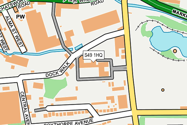
S49 1HQ is located in the Brampton East & Boythorpe electoral ward, within the local authority district of Chesterfield and the English Parliamentary constituency of Chesterfield. The Sub Integrated Care Board (ICB) Location is NHS Derby and Derbyshire ICB - 15M and the police force is Derbyshire. This postcode has been in use since December 1996.


GetTheData
Source: OS OpenMap – Local (Ordnance Survey)
Source: OS VectorMap District (Ordnance Survey)
Licence: Open Government Licence (requires attribution)
| Easting | 437593 |
| Northing | 370817 |
| Latitude | 53.233084 |
| Longitude | -1.438267 |
GetTheData
Source: Open Postcode Geo
Licence: Open Government Licence
| Country | England |
| Postcode District | S49 |
| ➜ S49 open data dashboard ➜ Where is Chesterfield? | |
GetTheData
Source: Land Registry Price Paid Data
Licence: Open Government Licence
Elevation or altitude of S49 1HQ as distance above sea level:
| Metres | Feet | |
|---|---|---|
| Elevation | 90m | 295ft |
Elevation is measured from the approximate centre of the postcode, to the nearest point on an OS contour line from OS Terrain 50, which has contour spacing of ten vertical metres.
➜ How high above sea level am I? Find the elevation of your current position using your device's GPS.
GetTheData
Source: Open Postcode Elevation
Licence: Open Government Licence
| Ward | Brampton East & Boythorpe |
| Constituency | Chesterfield |
GetTheData
Source: ONS Postcode Database
Licence: Open Government Licence
| January 2024 | Violence and sexual offences | On or near Park/Open Space | 254m |
| January 2024 | Anti-social behaviour | On or near Park/Open Space | 254m |
| October 2023 | Anti-social behaviour | On or near Park/Open Space | 254m |
| ➜ Get more crime data in our Crime section | |||
GetTheData
Source: data.police.uk
Licence: Open Government Licence
| Sports Centre (Boythorpe Road) | Boythorpe | 121m |
| Sports Centre (Boythorpe Road) | Boythorpe | 163m |
| Boythorpe Road Bottom (Boythorpe Road) | Chesterfield | 164m |
| Boythorpe Road Bottom (Boythorpe Road) | Chesterfield | 176m |
| Wheatbridge Road | Chesterfield | 207m |
| Chesterfield Station | 1.3km |
GetTheData
Source: NaPTAN
Licence: Open Government Licence
GetTheData
Source: ONS Postcode Database
Licence: Open Government Licence

➜ Get more ratings from the Food Standards Agency
GetTheData
Source: Food Standards Agency
Licence: FSA terms & conditions
| Last Collection | |||
|---|---|---|---|
| Location | Mon-Fri | Sat | Distance |
| 35 Chatsworth Road | 17:30 | 11:15 | 288m |
| Chesterfield Delivery Office | 18:45 | 341m | |
| 160 Chatsworth Road | 16:45 | 11:00 | 422m |
GetTheData
Source: Dracos
Licence: Creative Commons Attribution-ShareAlike
| Facility | Distance |
|---|---|
| Parkside Community School Boythorpe Avenue, Chesterfield Grass Pitches, Sports Hall | 344m |
| Queen's Park Sports Centre Boythorpe Avenue, Chesterfield Athletics, Grass Pitches, Outdoor Tennis Courts, Health and Fitness Gym, Sports Hall, Squash Courts, Swimming Pool, Artificial Grass Pitch, Studio | 354m |
| Manor Centre (Closed) Ashgate Road, Chesterfield Health and Fitness Gym, Swimming Pool | 616m |
GetTheData
Source: Active Places
Licence: Open Government Licence
| School | Phase of Education | Distance |
|---|---|---|
| Parkside Community School Boythorpe Avenue, Boythorpe, Chesterfield, S40 2NS | Secondary | 354m |
| William Rhodes Primary and Nursery School Hunloke Avenue, Boythorpe, Chesterfield, S40 2NR | Primary | 385m |
| Brampton Primary School School Board Lane, Brampton, Chesterfield, S40 1DD | Primary | 528m |
GetTheData
Source: Edubase
Licence: Open Government Licence
The below table lists the International Territorial Level (ITL) codes (formerly Nomenclature of Territorial Units for Statistics (NUTS) codes) and Local Administrative Units (LAU) codes for S49 1HQ:
| ITL 1 Code | Name |
|---|---|
| TLF | East Midlands (England) |
| ITL 2 Code | Name |
| TLF1 | Derbyshire and Nottinghamshire |
| ITL 3 Code | Name |
| TLF12 | East Derbyshire |
| LAU 1 Code | Name |
| E07000034 | Chesterfield |
GetTheData
Source: ONS Postcode Directory
Licence: Open Government Licence
The below table lists the Census Output Area (OA), Lower Layer Super Output Area (LSOA), and Middle Layer Super Output Area (MSOA) for S49 1HQ:
| Code | Name | |
|---|---|---|
| OA | E00098898 | |
| LSOA | E01019556 | Chesterfield 010C |
| MSOA | E02004064 | Chesterfield 010 |
GetTheData
Source: ONS Postcode Directory
Licence: Open Government Licence
| S40 2NQ | Boythorpe Road | 90m |
| S40 2NF | Boythorpe Road | 94m |
| S40 2QG | Minimum Terrace | 149m |
| S40 2QE | Boythorpe Avenue | 149m |
| S40 2QF | Riber Terrace | 188m |
| S40 2QQ | Walton Walk | 215m |
| S40 2QD | Boythorpe Mount | 238m |
| S40 2QB | Boythorpe Avenue | 245m |
| S40 2AQ | Chatsworth Road | 256m |
| S40 2AX | Alma Street West | 276m |
GetTheData
Source: Open Postcode Geo; Land Registry Price Paid Data
Licence: Open Government Licence