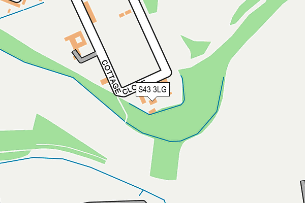
S43 3LG lies on Co Op Cottage in Poolsbrook, Chesterfield. S43 3LG is located in the Staveley Central electoral ward, within the local authority district of Chesterfield and the English Parliamentary constituency of Chesterfield. The Sub Integrated Care Board (ICB) Location is NHS Derby and Derbyshire ICB - 15M and the police force is Derbyshire. This postcode has been in use since September 1981.


GetTheData
Source: OS OpenMap – Local (Ordnance Survey)
Source: OS VectorMap District (Ordnance Survey)
Licence: Open Government Licence (requires attribution)
| Easting | 444384 |
| Northing | 373315 |
| Latitude | 53.254995 |
| Longitude | -1.336190 |
GetTheData
Source: Open Postcode Geo
Licence: Open Government Licence
| Street | Co Op Cottage |
| Locality | Poolsbrook |
| Town/City | Chesterfield |
| Country | England |
| Postcode District | S43 |
| ➜ S43 open data dashboard ➜ See where S43 is on a map ➜ Where is Staveley? | |
GetTheData
Source: Land Registry Price Paid Data
Licence: Open Government Licence
Elevation or altitude of S43 3LG as distance above sea level:
| Metres | Feet | |
|---|---|---|
| Elevation | 60m | 197ft |
Elevation is measured from the approximate centre of the postcode, to the nearest point on an OS contour line from OS Terrain 50, which has contour spacing of ten vertical metres.
➜ How high above sea level am I? Find the elevation of your current position using your device's GPS.
GetTheData
Source: Open Postcode Elevation
Licence: Open Government Licence
| Ward | Staveley Central |
| Constituency | Chesterfield |
GetTheData
Source: ONS Postcode Database
Licence: Open Government Licence
| December 2023 | Violence and sexual offences | On or near Poolsbrook Square | 361m |
| October 2023 | Violence and sexual offences | On or near Poolsbrook Square | 361m |
| October 2023 | Criminal damage and arson | On or near Poolsbrook Square | 361m |
| ➜ Get more crime data in our Crime section | |||
GetTheData
Source: data.police.uk
Licence: Open Government Licence
| The Grove | Poolsbrook | 400m |
| The Grove | Poolsbrook | 406m |
| Staveley Road | Poolsbrook | 537m |
| Staveley Road | Poolsbrook | 540m |
| Pools Brook Country Park (Erin Road) | Poolsbrook | 828m |
GetTheData
Source: NaPTAN
Licence: Open Government Licence
| Percentage of properties with Next Generation Access | 100.0% |
| Percentage of properties with Superfast Broadband | 100.0% |
| Percentage of properties with Ultrafast Broadband | 0.0% |
| Percentage of properties with Full Fibre Broadband | 0.0% |
Superfast Broadband is between 30Mbps and 300Mbps
Ultrafast Broadband is > 300Mbps
| Percentage of properties unable to receive 2Mbps | 0.0% |
| Percentage of properties unable to receive 5Mbps | 0.0% |
| Percentage of properties unable to receive 10Mbps | 0.0% |
| Percentage of properties unable to receive 30Mbps | 0.0% |
GetTheData
Source: Ofcom
Licence: Ofcom Terms of Use (requires attribution)
GetTheData
Source: ONS Postcode Database
Licence: Open Government Licence


➜ Get more ratings from the Food Standards Agency
GetTheData
Source: Food Standards Agency
Licence: FSA terms & conditions
| Last Collection | |||
|---|---|---|---|
| Location | Mon-Fri | Sat | Distance |
| 4 The Grove | 16:00 | 10:45 | 402m |
| Poolsbrook Road | 14:00 | 09:00 | 1,014m |
| Netherthorpe | 16:00 | 10:30 | 1,351m |
GetTheData
Source: Dracos
Licence: Creative Commons Attribution-ShareAlike
| Facility | Distance |
|---|---|
| Poolsbrook Football Ground Cottage Close, Poolsbrook, Chesterfield Grass Pitches | 183m |
| Duckmanton Primary School West Crescent, Duckmanton, Chesterfield Grass Pitches | 936m |
| Varley Park (Closed) Poolsbrook Road, Duckmanton, Chesterfield Grass Pitches | 1.1km |
GetTheData
Source: Active Places
Licence: Open Government Licence
| School | Phase of Education | Distance |
|---|---|---|
| Poolsbrook Primary Academy Cottage Close, Poolsbrook, Chesterfield, S43 3LF | Primary | 199m |
| Duckmanton Primary School West Crescent, Duckmanton, Chesterfield, S44 5HD | Primary | 936m |
| Woodthorpe CofE Primary School Seymour Lane, Woodthorpe, Mastin Moor, Chesterfield, S43 3DA | Primary | 1.4km |
GetTheData
Source: Edubase
Licence: Open Government Licence
The below table lists the International Territorial Level (ITL) codes (formerly Nomenclature of Territorial Units for Statistics (NUTS) codes) and Local Administrative Units (LAU) codes for S43 3LG:
| ITL 1 Code | Name |
|---|---|
| TLF | East Midlands (England) |
| ITL 2 Code | Name |
| TLF1 | Derbyshire and Nottinghamshire |
| ITL 3 Code | Name |
| TLF12 | East Derbyshire |
| LAU 1 Code | Name |
| E07000034 | Chesterfield |
GetTheData
Source: ONS Postcode Directory
Licence: Open Government Licence
The below table lists the Census Output Area (OA), Lower Layer Super Output Area (LSOA), and Middle Layer Super Output Area (MSOA) for S43 3LG:
| Code | Name | |
|---|---|---|
| OA | E00098963 | |
| LSOA | E01019566 | Chesterfield 002D |
| MSOA | E02004056 | Chesterfield 002 |
GetTheData
Source: ONS Postcode Directory
Licence: Open Government Licence
| S43 3LF | 199m | |
| S43 3LD | Poolsbrook Square | 354m |
| S43 3LB | Poolsbrook Crescent | 390m |
| S43 3JX | Staveley Road | 407m |
| S43 3JZ | Poolsbrook Avenue | 459m |
| S43 3LA | Poolsbrook View | 527m |
| S43 3JU | Staveley Road | 538m |
| S44 5ES | East Crescent | 720m |
| S44 5HA | North Grove | 765m |
| S44 5ET | East Crescent | 781m |
GetTheData
Source: Open Postcode Geo; Land Registry Price Paid Data
Licence: Open Government Licence