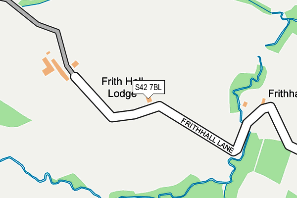
S42 7BL is located in the Brampton & Walton electoral ward, within the local authority district of North East Derbyshire and the English Parliamentary constituency of North East Derbyshire. The Sub Integrated Care Board (ICB) Location is NHS Derby and Derbyshire ICB - 15M and the police force is Derbyshire. This postcode has been in use since January 1980.


GetTheData
Source: OS OpenMap – Local (Ordnance Survey)
Source: OS VectorMap District (Ordnance Survey)
Licence: Open Government Licence (requires attribution)
| Easting | 433311 |
| Northing | 370901 |
| Latitude | 53.234123 |
| Longitude | -1.502405 |
GetTheData
Source: Open Postcode Geo
Licence: Open Government Licence
| Country | England |
| Postcode District | S42 |
| ➜ S42 open data dashboard ➜ See where S42 is on a map | |
GetTheData
Source: Land Registry Price Paid Data
Licence: Open Government Licence
Elevation or altitude of S42 7BL as distance above sea level:
| Metres | Feet | |
|---|---|---|
| Elevation | 160m | 525ft |
Elevation is measured from the approximate centre of the postcode, to the nearest point on an OS contour line from OS Terrain 50, which has contour spacing of ten vertical metres.
➜ How high above sea level am I? Find the elevation of your current position using your device's GPS.
GetTheData
Source: Open Postcode Elevation
Licence: Open Government Licence
| Ward | Brampton & Walton |
| Constituency | North East Derbyshire |
GetTheData
Source: ONS Postcode Database
Licence: Open Government Licence
| May 2022 | Anti-social behaviour | On or near Baslow Road | 436m |
| February 2022 | Vehicle crime | On or near Baslow Road | 436m |
| June 2021 | Public order | On or near Petrol Station | 435m |
| ➜ Get more crime data in our Crime section | |||
GetTheData
Source: data.police.uk
Licence: Open Government Licence
| Chanderhill (Baslow Road) | Holymoorside | 484m |
| Chanderhill (Baslow Road) | Holymoorside | 501m |
| Hemming Green | Old Brampton | 935m |
| Hemming Green | Old Brampton | 941m |
| St Peter And St Paul Church (Ashgate Road) | Old Brampton | 1,020m |
GetTheData
Source: NaPTAN
Licence: Open Government Licence
| Percentage of properties with Next Generation Access | 100.0% |
| Percentage of properties with Superfast Broadband | 33.3% |
| Percentage of properties with Ultrafast Broadband | 0.0% |
| Percentage of properties with Full Fibre Broadband | 0.0% |
Superfast Broadband is between 30Mbps and 300Mbps
Ultrafast Broadband is > 300Mbps
| Percentage of properties unable to receive 2Mbps | 66.7% |
| Percentage of properties unable to receive 5Mbps | 66.7% |
| Percentage of properties unable to receive 10Mbps | 66.7% |
| Percentage of properties unable to receive 30Mbps | 66.7% |
GetTheData
Source: Ofcom
Licence: Ofcom Terms of Use (requires attribution)
GetTheData
Source: ONS Postcode Database
Licence: Open Government Licence


➜ Get more ratings from the Food Standards Agency
GetTheData
Source: Food Standards Agency
Licence: FSA terms & conditions
| Last Collection | |||
|---|---|---|---|
| Location | Mon-Fri | Sat | Distance |
| Westwick Lane | 16:00 | 08:30 | 467m |
| Main Road | 16:00 | 09:00 | 1,033m |
| Ashgate Road | 16:00 | 09:00 | 1,599m |
GetTheData
Source: Dracos
Licence: Creative Commons Attribution-ShareAlike
| Facility | Distance |
|---|---|
| Walton Holymoorside Primary & Nursery School Holymoor Road, Holymoorside, Chesterfield Sports Hall, Grass Pitches | 1.5km |
| Holymoorside Recreation Ground Holymoor Road, Holymoorside Grass Pitches, Outdoor Tennis Courts | 1.7km |
| Brookfield Academy Chatsworth Road, Chesterfield Sports Hall, Athletics, Swimming Pool, Grass Pitches, Artificial Grass Pitch, Studio | 2.1km |
GetTheData
Source: Active Places
Licence: Open Government Licence
| School | Phase of Education | Distance |
|---|---|---|
| Walton Holymoorside Primary School Holymoor Road, Holymoorside, Chesterfield, S42 7DU | Primary | 1.5km |
| Wigley Primary School Wigley, Old Brampton, Chesterfield, S42 7JJ | Primary | 2km |
| Brookfield Community School Chatsworth Road, Chesterfield, S40 3NS | Secondary | 2.1km |
GetTheData
Source: Edubase
Licence: Open Government Licence
The below table lists the International Territorial Level (ITL) codes (formerly Nomenclature of Territorial Units for Statistics (NUTS) codes) and Local Administrative Units (LAU) codes for S42 7BL:
| ITL 1 Code | Name |
|---|---|
| TLF | East Midlands (England) |
| ITL 2 Code | Name |
| TLF1 | Derbyshire and Nottinghamshire |
| ITL 3 Code | Name |
| TLF12 | East Derbyshire |
| LAU 1 Code | Name |
| E07000038 | North East Derbyshire |
GetTheData
Source: ONS Postcode Directory
Licence: Open Government Licence
The below table lists the Census Output Area (OA), Lower Layer Super Output Area (LSOA), and Middle Layer Super Output Area (MSOA) for S42 7BL:
| Code | Name | |
|---|---|---|
| OA | E00100040 | |
| LSOA | E01019771 | North East Derbyshire 008A |
| MSOA | E02004112 | North East Derbyshire 008 |
GetTheData
Source: ONS Postcode Directory
Licence: Open Government Licence
| S42 7BJ | Westwick Lane | 391m |
| S42 7BH | Baslow Road | 613m |
| S42 7BW | Chander Hill | 705m |
| S42 7HJ | Baslow Road | 900m |
| S42 7JQ | Hemming Green | 962m |
| S42 7HL | Pocknedge Lane | 1025m |
| S42 7DN | Belmont Park | 1122m |
| S42 7JG | Main Road | 1123m |
| S42 7DS | Holymoor Road | 1234m |
| S42 7DR | Holymoor Road | 1252m |
GetTheData
Source: Open Postcode Geo; Land Registry Price Paid Data
Licence: Open Government Licence