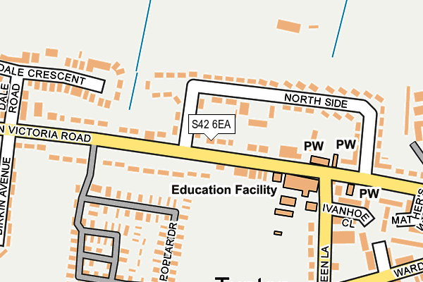
S42 6EA lies on Queen Victoria Road in New Tupton, Chesterfield. S42 6EA is located in the Tupton electoral ward, within the local authority district of North East Derbyshire and the English Parliamentary constituency of North East Derbyshire. The Sub Integrated Care Board (ICB) Location is NHS Derby and Derbyshire ICB - 15M and the police force is Derbyshire. This postcode has been in use since January 1980.


GetTheData
Source: OS OpenMap – Local (Ordnance Survey)
Source: OS VectorMap District (Ordnance Survey)
Licence: Open Government Licence (requires attribution)
| Easting | 439424 |
| Northing | 366172 |
| Latitude | 53.191201 |
| Longitude | -1.411409 |
GetTheData
Source: Open Postcode Geo
Licence: Open Government Licence
| Street | Queen Victoria Road |
| Locality | New Tupton |
| Town/City | Chesterfield |
| Country | England |
| Postcode District | S42 |
| ➜ S42 open data dashboard ➜ See where S42 is on a map ➜ Where is Tupton? | |
GetTheData
Source: Land Registry Price Paid Data
Licence: Open Government Licence
Elevation or altitude of S42 6EA as distance above sea level:
| Metres | Feet | |
|---|---|---|
| Elevation | 100m | 328ft |
Elevation is measured from the approximate centre of the postcode, to the nearest point on an OS contour line from OS Terrain 50, which has contour spacing of ten vertical metres.
➜ How high above sea level am I? Find the elevation of your current position using your device's GPS.
GetTheData
Source: Open Postcode Elevation
Licence: Open Government Licence
| Ward | Tupton |
| Constituency | North East Derbyshire |
GetTheData
Source: ONS Postcode Database
Licence: Open Government Licence
| June 2022 | Violence and sexual offences | On or near Bridgewater Street | 41m |
| June 2022 | Violence and sexual offences | On or near North Side | 118m |
| June 2022 | Anti-social behaviour | On or near North Side | 118m |
| ➜ Queen Victoria Road crime map and outcomes | |||
GetTheData
Source: data.police.uk
Licence: Open Government Licence
| Bridgewater Street (Queen Victoria Road) | New Tupton | 22m |
| Bridgewater Street (Queen Victoria Road) | New Tupton | 60m |
| Miners Welfare (Queen Victoria Road) | New Tupton | 122m |
| Miners Welfare (Queen Victoria Road) | New Tupton | 130m |
| Post Office (Green Lane) | Tupton | 228m |
GetTheData
Source: NaPTAN
Licence: Open Government Licence
| Percentage of properties with Next Generation Access | 100.0% |
| Percentage of properties with Superfast Broadband | 100.0% |
| Percentage of properties with Ultrafast Broadband | 0.0% |
| Percentage of properties with Full Fibre Broadband | 0.0% |
Superfast Broadband is between 30Mbps and 300Mbps
Ultrafast Broadband is > 300Mbps
| Percentage of properties unable to receive 2Mbps | 0.0% |
| Percentage of properties unable to receive 5Mbps | 0.0% |
| Percentage of properties unable to receive 10Mbps | 0.0% |
| Percentage of properties unable to receive 30Mbps | 0.0% |
GetTheData
Source: Ofcom
Licence: Ofcom Terms of Use (requires attribution)
GetTheData
Source: ONS Postcode Database
Licence: Open Government Licence


➜ Get more ratings from the Food Standards Agency
GetTheData
Source: Food Standards Agency
Licence: FSA terms & conditions
| Last Collection | |||
|---|---|---|---|
| Location | Mon-Fri | Sat | Distance |
| New Tupton Post Office | 16:00 | 11:00 | 283m |
| Birkin Avenue | 16:00 | 11:00 | 298m |
| Halcyon Approach | 16:00 | 11:15 | 598m |
GetTheData
Source: Dracos
Licence: Creative Commons Attribution-ShareAlike
| Facility | Distance |
|---|---|
| Tupton Recreation Ground North Side, New Tupton Grass Pitches | 149m |
| Tupton Primary School Queen Victoria Road, New Tupton, Chesterfield Grass Pitches | 210m |
| Hunloke Recreation Ground Adlington Avenue, Wingerworth Grass Pitches | 562m |
GetTheData
Source: Active Places
Licence: Open Government Licence
| School | Phase of Education | Distance |
|---|---|---|
| Tupton Primary and Nursery Academy Queen Victoria Road, New Tupton, Chesterfield, S42 6DY | Primary | 136m |
| Tupton Hall School Station New Road, Old Tupton, Chesterfield, S42 6LG | Secondary | 1km |
| Grassmoor Primary School North Wingfield Road, Grassmoor, Chesterfield, S42 5EP | Primary | 1.3km |
GetTheData
Source: Edubase
Licence: Open Government Licence
The below table lists the International Territorial Level (ITL) codes (formerly Nomenclature of Territorial Units for Statistics (NUTS) codes) and Local Administrative Units (LAU) codes for S42 6EA:
| ITL 1 Code | Name |
|---|---|
| TLF | East Midlands (England) |
| ITL 2 Code | Name |
| TLF1 | Derbyshire and Nottinghamshire |
| ITL 3 Code | Name |
| TLF12 | East Derbyshire |
| LAU 1 Code | Name |
| E07000038 | North East Derbyshire |
GetTheData
Source: ONS Postcode Directory
Licence: Open Government Licence
The below table lists the Census Output Area (OA), Lower Layer Super Output Area (LSOA), and Middle Layer Super Output Area (MSOA) for S42 6EA:
| Code | Name | |
|---|---|---|
| OA | E00100329 | |
| LSOA | E01019824 | North East Derbyshire 010C |
| MSOA | E02004114 | North East Derbyshire 010 |
GetTheData
Source: ONS Postcode Directory
Licence: Open Government Licence
| S42 6EB | Colenso Place | 19m |
| S42 6DY | Queen Victoria Road | 51m |
| S42 6BP | Bridgewater Street | 57m |
| S42 6ED | Queen Victoria Road | 83m |
| S42 6BN | Northside | 98m |
| S42 6BW | Northside | 140m |
| S42 6DU | Queen Victoria Road | 167m |
| S42 6BL | Queen Victoria Road | 193m |
| S42 6DS | Dale Crescent | 204m |
| S42 6XW | Green Lane | 217m |
GetTheData
Source: Open Postcode Geo; Land Registry Price Paid Data
Licence: Open Government Licence