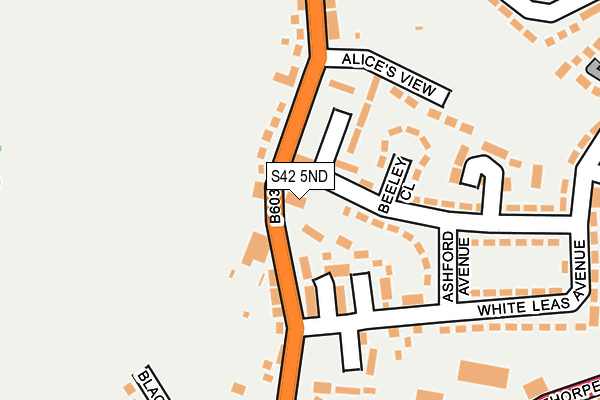
S42 5ND is located in the North Wingfield Central electoral ward, within the local authority district of North East Derbyshire and the English Parliamentary constituency of North East Derbyshire. The Sub Integrated Care Board (ICB) Location is NHS Derby and Derbyshire ICB - 15M and the police force is Derbyshire. This postcode has been in use since January 1980.


GetTheData
Source: OS OpenMap – Local (Ordnance Survey)
Source: OS VectorMap District (Ordnance Survey)
Licence: Open Government Licence (requires attribution)
| Easting | 441013 |
| Northing | 365421 |
| Latitude | 53.184311 |
| Longitude | -1.387727 |
GetTheData
Source: Open Postcode Geo
Licence: Open Government Licence
| Country | England |
| Postcode District | S42 |
| ➜ S42 open data dashboard ➜ See where S42 is on a map ➜ Where is North Wingfield? | |
GetTheData
Source: Land Registry Price Paid Data
Licence: Open Government Licence
Elevation or altitude of S42 5ND as distance above sea level:
| Metres | Feet | |
|---|---|---|
| Elevation | 130m | 427ft |
Elevation is measured from the approximate centre of the postcode, to the nearest point on an OS contour line from OS Terrain 50, which has contour spacing of ten vertical metres.
➜ How high above sea level am I? Find the elevation of your current position using your device's GPS.
GetTheData
Source: Open Postcode Elevation
Licence: Open Government Licence
| Ward | North Wingfield Central |
| Constituency | North East Derbyshire |
GetTheData
Source: ONS Postcode Database
Licence: Open Government Licence
| January 2024 | Violence and sexual offences | On or near Eyam Close | 327m |
| December 2023 | Violence and sexual offences | On or near Petrol Station | 304m |
| December 2023 | Criminal damage and arson | On or near Eyam Close | 327m |
| ➜ Get more crime data in our Crime section | |||
GetTheData
Source: data.police.uk
Licence: Open Government Licence
| Deincourt School (Chesterfield Road) | North Wingfield | 117m |
| Ashford Avenue (Whiteleas Avenue) | North Wingfield | 149m |
| Ashford Avenue (Whiteleas Avenue) | North Wingfield | 166m |
| The Green (Chesterfield Road) | North Wingfield | 180m |
| The Green (Chesterfield Road) | North Wingfield | 201m |
GetTheData
Source: NaPTAN
Licence: Open Government Licence
GetTheData
Source: ONS Postcode Database
Licence: Open Government Licence


➜ Get more ratings from the Food Standards Agency
GetTheData
Source: Food Standards Agency
Licence: FSA terms & conditions
| Last Collection | |||
|---|---|---|---|
| Location | Mon-Fri | Sat | Distance |
| North Wingfield Post Office | 16:00 | 11:15 | 314m |
| Bamford Avenue | 16:00 | 08:00 | 473m |
| Chesterfield Road | 16:00 | 11:15 | 521m |
GetTheData
Source: Dracos
Licence: Creative Commons Attribution-ShareAlike
| Facility | Distance |
|---|---|
| Tibshelf School - Northingfield Site (Closed) Chesterfield Road, North Wingfield, Chesterfield Sports Hall, Grass Pitches | 292m |
| King George V Playing Field (North Wingfield) Holbrook Avenue, North Wingfield Grass Pitches | 570m |
| Leigh Way Playing Field Leigh Way, North Wingfield, Chesterfield Grass Pitches | 606m |
GetTheData
Source: Active Places
Licence: Open Government Licence
| School | Phase of Education | Distance |
|---|---|---|
| North Wingfield Primary and Nursery Academy 80 Chesterfield Road, North Wingfield, S42 5LE | Primary | 307m |
| Grassmoor Primary School North Wingfield Road, Grassmoor, Chesterfield, S42 5EP | Primary | 1.4km |
| Tupton Hall School Station New Road, Old Tupton, Chesterfield, S42 6LG | Secondary | 1.5km |
GetTheData
Source: Edubase
Licence: Open Government Licence
The below table lists the International Territorial Level (ITL) codes (formerly Nomenclature of Territorial Units for Statistics (NUTS) codes) and Local Administrative Units (LAU) codes for S42 5ND:
| ITL 1 Code | Name |
|---|---|
| TLF | East Midlands (England) |
| ITL 2 Code | Name |
| TLF1 | Derbyshire and Nottinghamshire |
| ITL 3 Code | Name |
| TLF12 | East Derbyshire |
| LAU 1 Code | Name |
| E07000038 | North East Derbyshire |
GetTheData
Source: ONS Postcode Directory
Licence: Open Government Licence
The below table lists the Census Output Area (OA), Lower Layer Super Output Area (LSOA), and Middle Layer Super Output Area (MSOA) for S42 5ND:
| Code | Name | |
|---|---|---|
| OA | E00100255 | |
| LSOA | E01019808 | North East Derbyshire 009E |
| MSOA | E02004113 | North East Derbyshire 009 |
GetTheData
Source: ONS Postcode Directory
Licence: Open Government Licence
| S42 5LG | Chesterfield Road | 105m |
| S42 5PN | Ashford Avenue | 148m |
| S42 5PW | Whiteleas Avenue | 169m |
| S42 5PJ | Greenland Close | 185m |
| S42 5WA | Calver Avenue | 186m |
| S42 5QJ | Whiteleas Avenue | 237m |
| S42 5LW | Blacks Lane | 268m |
| S42 5QH | Whiteleas Avenue | 272m |
| S42 5NF | The Green | 274m |
| S42 5QD | Lings Crescent | 277m |
GetTheData
Source: Open Postcode Geo; Land Registry Price Paid Data
Licence: Open Government Licence