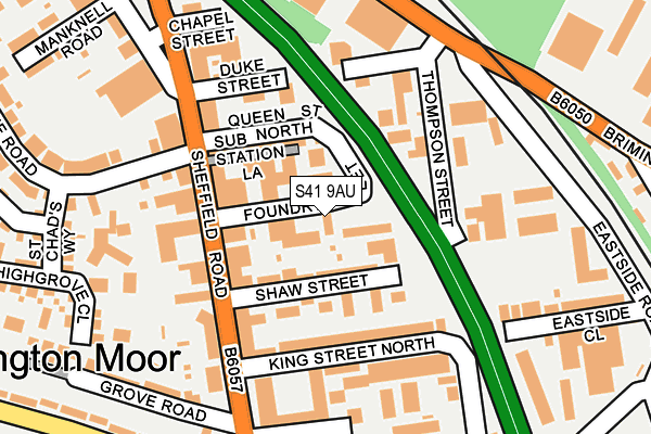
S41 9AU is located in the Whittington Moor electoral ward, within the local authority district of Chesterfield and the English Parliamentary constituency of Chesterfield. The Sub Integrated Care Board (ICB) Location is NHS Derby and Derbyshire ICB - 15M and the police force is Derbyshire. This postcode has been in use since January 1980.


GetTheData
Source: OS OpenMap – Local (Ordnance Survey)
Source: OS VectorMap District (Ordnance Survey)
Licence: Open Government Licence (requires attribution)
| Easting | 438356 |
| Northing | 373609 |
| Latitude | 53.258106 |
| Longitude | -1.426503 |
GetTheData
Source: Open Postcode Geo
Licence: Open Government Licence
| Country | England |
| Postcode District | S41 |
| ➜ S41 open data dashboard ➜ See where S41 is on a map ➜ Where is Chesterfield? | |
GetTheData
Source: Land Registry Price Paid Data
Licence: Open Government Licence
Elevation or altitude of S41 9AU as distance above sea level:
| Metres | Feet | |
|---|---|---|
| Elevation | 70m | 230ft |
Elevation is measured from the approximate centre of the postcode, to the nearest point on an OS contour line from OS Terrain 50, which has contour spacing of ten vertical metres.
➜ How high above sea level am I? Find the elevation of your current position using your device's GPS.
GetTheData
Source: Open Postcode Elevation
Licence: Open Government Licence
| Ward | Whittington Moor |
| Constituency | Chesterfield |
GetTheData
Source: ONS Postcode Database
Licence: Open Government Licence
| June 2022 | Criminal damage and arson | On or near Thompson Close | 151m |
| June 2022 | Anti-social behaviour | On or near School Road | 200m |
| June 2022 | Shoplifting | On or near School Road | 200m |
| ➜ Get more crime data in our Crime section | |||
GetTheData
Source: data.police.uk
Licence: Open Government Licence
| Derby Tup (Sheffield Road) | Whittington Moor | 132m |
| Lidl (Sheffield Road) | Whittington Moor | 163m |
| Peter Webster Centre (Sheffield Road) | Whittington Moor | 174m |
| Lidl (Sheffield Road) | Whittington Moor | 192m |
| Lidl (Sheffield Road) | Whittington Moor | 215m |
| Chesterfield Station | 2.3km |
| Dronfield Station | 5.6km |
GetTheData
Source: NaPTAN
Licence: Open Government Licence
GetTheData
Source: ONS Postcode Database
Licence: Open Government Licence


➜ Get more ratings from the Food Standards Agency
GetTheData
Source: Food Standards Agency
Licence: FSA terms & conditions
| Last Collection | |||
|---|---|---|---|
| Location | Mon-Fri | Sat | Distance |
| Highfield Lane | 16:00 | 11:00 | 152m |
| Dunston Road | 18:30 | 371m | |
| Stand Road | 16:00 | 11:00 | 499m |
GetTheData
Source: Dracos
Licence: Creative Commons Attribution-ShareAlike
| Facility | Distance |
|---|---|
| Lifestyles (Chesterfield) (Closed) Station Road, Whittington Moor, Chesterfield Health and Fitness Gym, Studio | 188m |
| Stand Road Park Stand Road, Chesterfield Grass Pitches | 420m |
| Body Progress Gymnasium (Closed) Pottery Lane East, Chesterfield Health and Fitness Gym | 430m |
GetTheData
Source: Active Places
Licence: Open Government Licence
| School | Phase of Education | Distance |
|---|---|---|
| Whittington Moor Nursery and Infant Academy Scarsdale Road, Whittington Moor, Chesterfield, S41 8NF | Primary | 422m |
| Cavendish Junior School Edmund Street, Newbold Moor, Chesterfield, S41 8TD | Primary | 645m |
| Outwood Academy Newbold Highfield Lane, Newbold, Chesterfield, S41 8BA | Secondary | 926m |
GetTheData
Source: Edubase
Licence: Open Government Licence
The below table lists the International Territorial Level (ITL) codes (formerly Nomenclature of Territorial Units for Statistics (NUTS) codes) and Local Administrative Units (LAU) codes for S41 9AU:
| ITL 1 Code | Name |
|---|---|
| TLF | East Midlands (England) |
| ITL 2 Code | Name |
| TLF1 | Derbyshire and Nottinghamshire |
| ITL 3 Code | Name |
| TLF12 | East Derbyshire |
| LAU 1 Code | Name |
| E07000034 | Chesterfield |
GetTheData
Source: ONS Postcode Directory
Licence: Open Government Licence
The below table lists the Census Output Area (OA), Lower Layer Super Output Area (LSOA), and Middle Layer Super Output Area (MSOA) for S41 9AU:
| Code | Name | |
|---|---|---|
| OA | E00098979 | |
| LSOA | E01019569 | Chesterfield 007B |
| MSOA | E02004061 | Chesterfield 007 |
GetTheData
Source: ONS Postcode Directory
Licence: Open Government Licence
| S41 9AY | Shaw Street | 56m |
| S41 9AB | Queen Street North | 88m |
| S41 8LS | Sheffield Road | 103m |
| S41 9BA | King Street North | 116m |
| S41 8LT | Sheffield Road | 119m |
| S41 8LP | Sheffield Road | 129m |
| S41 8LL | Sheffield Road | 136m |
| S41 9AR | Thompson Street | 136m |
| S41 9AZ | Thompson Close | 152m |
| S41 9AQ | Station Road | 193m |
GetTheData
Source: Open Postcode Geo; Land Registry Price Paid Data
Licence: Open Government Licence