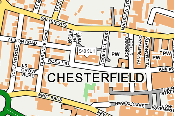
S40 9UH is located in the Spire electoral ward, within the local authority district of Chesterfield and the English Parliamentary constituency of Chesterfield. The Sub Integrated Care Board (ICB) Location is NHS Derby and Derbyshire ICB - 15M and the police force is Derbyshire. This postcode has been in use since February 2013.


GetTheData
Source: OS OpenMap – Local (Ordnance Survey)
Source: OS VectorMap District (Ordnance Survey)
Licence: Open Government Licence (requires attribution)
| Easting | 437985 |
| Northing | 371228 |
| Latitude | 53.236731 |
| Longitude | -1.432347 |
GetTheData
Source: Open Postcode Geo
Licence: Open Government Licence
| Country | England |
| Postcode District | S40 |
| ➜ S40 open data dashboard ➜ See where S40 is on a map ➜ Where is Chesterfield? | |
GetTheData
Source: Land Registry Price Paid Data
Licence: Open Government Licence
Elevation or altitude of S40 9UH as distance above sea level:
| Metres | Feet | |
|---|---|---|
| Elevation | 100m | 328ft |
Elevation is measured from the approximate centre of the postcode, to the nearest point on an OS contour line from OS Terrain 50, which has contour spacing of ten vertical metres.
➜ How high above sea level am I? Find the elevation of your current position using your device's GPS.
GetTheData
Source: Open Postcode Elevation
Licence: Open Government Licence
| Ward | Spire |
| Constituency | Chesterfield |
GetTheData
Source: ONS Postcode Database
Licence: Open Government Licence
| January 2024 | Violence and sexual offences | On or near Parking Area | 72m |
| January 2024 | Anti-social behaviour | On or near Park/Open Space | 368m |
| January 2024 | Violence and sexual offences | On or near Park/Open Space | 368m |
| ➜ Get more crime data in our Crime section | |||
GetTheData
Source: data.police.uk
Licence: Open Government Licence
| Town Hall (Rose Hill West) | Chesterfield | 59m |
| Rose Hill | Chesterfield | 100m |
| Town Hall (Saltergate) | Chesterfield | 101m |
| Town Hall (Saltergate) | Chesterfield | 115m |
| Rose Hill | Chesterfield | 128m |
| Chesterfield Station | 0.8km |
GetTheData
Source: NaPTAN
Licence: Open Government Licence
GetTheData
Source: ONS Postcode Database
Licence: Open Government Licence


➜ Get more ratings from the Food Standards Agency
GetTheData
Source: Food Standards Agency
Licence: FSA terms & conditions
| Last Collection | |||
|---|---|---|---|
| Location | Mon-Fri | Sat | Distance |
| Saltergate | 16:45 | 11:30 | 181m |
| Post Office | 18:30 | 12:00 | 191m |
| Chesterfield Delivery Office | 18:45 | 232m | |
GetTheData
Source: Dracos
Licence: Creative Commons Attribution-ShareAlike
| Facility | Distance |
|---|---|
| Curves For Women (Chesterfield) (Closed) Burlington Street, Chesterfield Health and Fitness Gym | 389m |
| St Marys Catholic Primary School Cross Street, Chesterfield Grass Pitches, Sports Hall | 408m |
| Manor Centre (Closed) Ashgate Road, Chesterfield Health and Fitness Gym, Swimming Pool | 487m |
GetTheData
Source: Active Places
Licence: Open Government Licence
| School | Phase of Education | Distance |
|---|---|---|
| St Mary's Catholic Primary Cross Street, Chesterfield, S40 4ST | Primary | 408m |
| Chesterfield College Infirmary Road, Chesterfield, S41 7NG | 16 plus | 625m |
| Abercrombie Primary School Higher Albert Street, Chesterfield, S41 7QE | Primary | 715m |
GetTheData
Source: Edubase
Licence: Open Government Licence
The below table lists the International Territorial Level (ITL) codes (formerly Nomenclature of Territorial Units for Statistics (NUTS) codes) and Local Administrative Units (LAU) codes for S40 9UH:
| ITL 1 Code | Name |
|---|---|
| TLF | East Midlands (England) |
| ITL 2 Code | Name |
| TLF1 | Derbyshire and Nottinghamshire |
| ITL 3 Code | Name |
| TLF12 | East Derbyshire |
| LAU 1 Code | Name |
| E07000034 | Chesterfield |
GetTheData
Source: ONS Postcode Directory
Licence: Open Government Licence
The below table lists the Census Output Area (OA), Lower Layer Super Output Area (LSOA), and Middle Layer Super Output Area (MSOA) for S40 9UH:
| Code | Name | |
|---|---|---|
| OA | E00098823 | |
| LSOA | E01019538 | Chesterfield 010A |
| MSOA | E02004064 | Chesterfield 010 |
GetTheData
Source: ONS Postcode Directory
Licence: Open Government Licence
| S40 1LW | Rose Hill | 84m |
| S40 1LJ | Albion Road | 109m |
| S40 9ZZ | Saltergate | 129m |
| S40 1LG | Saltergate | 138m |
| S40 1LA | Saltergate | 151m |
| S40 1LQ | Clarence Road | 156m |
| S40 1JN | Soresby Street | 157m |
| S40 1LU | Clarence Road | 166m |
| S40 1AH | New Square | 167m |
| S40 1LN | Clarence Road | 170m |
GetTheData
Source: Open Postcode Geo; Land Registry Price Paid Data
Licence: Open Government Licence