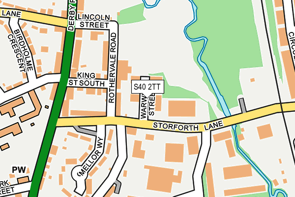
S40 2TT is located in the Rother electoral ward, within the local authority district of Chesterfield and the English Parliamentary constituency of Chesterfield. The Sub Integrated Care Board (ICB) Location is NHS Derby and Derbyshire ICB - 15M and the police force is Derbyshire. This postcode has been in use since March 1982.


GetTheData
Source: OS OpenMap – Local (Ordnance Survey)
Source: OS VectorMap District (Ordnance Survey)
Licence: Open Government Licence (requires attribution)
| Easting | 438532 |
| Northing | 369431 |
| Latitude | 53.220540 |
| Longitude | -1.424368 |
GetTheData
Source: Open Postcode Geo
Licence: Open Government Licence
| Country | England |
| Postcode District | S40 |
| ➜ S40 open data dashboard ➜ See where S40 is on a map ➜ Where is Chesterfield? | |
GetTheData
Source: Land Registry Price Paid Data
Licence: Open Government Licence
Elevation or altitude of S40 2TT as distance above sea level:
| Metres | Feet | |
|---|---|---|
| Elevation | 80m | 262ft |
Elevation is measured from the approximate centre of the postcode, to the nearest point on an OS contour line from OS Terrain 50, which has contour spacing of ten vertical metres.
➜ How high above sea level am I? Find the elevation of your current position using your device's GPS.
GetTheData
Source: Open Postcode Elevation
Licence: Open Government Licence
| Ward | Rother |
| Constituency | Chesterfield |
GetTheData
Source: ONS Postcode Database
Licence: Open Government Licence
| December 2023 | Violence and sexual offences | On or near Bacons Lane | 483m |
| December 2023 | Anti-social behaviour | On or near Bacons Lane | 483m |
| October 2023 | Violence and sexual offences | On or near Bacons Lane | 483m |
| ➜ Get more crime data in our Crime section | |||
GetTheData
Source: data.police.uk
Licence: Open Government Licence
| Mellor Way (Storforth Lane) | Birdholme | 57m |
| Brittania Road (Storforth Lane) | Birdholme | 98m |
| Brittania Road (Storforth Lane) | Birdholme | 133m |
| Mellor Way (Storforth Lane) | Birdholme | 142m |
| King Street South (Derby Road) | Birdholme | 175m |
| Chesterfield Station | 2km |
GetTheData
Source: NaPTAN
Licence: Open Government Licence
GetTheData
Source: ONS Postcode Database
Licence: Open Government Licence


➜ Get more ratings from the Food Standards Agency
GetTheData
Source: Food Standards Agency
Licence: FSA terms & conditions
| Last Collection | |||
|---|---|---|---|
| Location | Mon-Fri | Sat | Distance |
| Birdholme Post Office | 17:00 | 11:30 | 184m |
| Langer Lane | 17:15 | 11:45 | 463m |
| Church Street South | 17:15 | 11:45 | 594m |
GetTheData
Source: Dracos
Licence: Creative Commons Attribution-ShareAlike
| Facility | Distance |
|---|---|
| Rother Recreation Ground Rothervale Road, Chesterfield Grass Pitches | 104m |
| Langer Lane Langer Lane, Chesterfield Grass Pitches | 495m |
| Chesterfield Fc Training Ground Whitebank Close, Chesterfield Grass Pitches | 715m |
GetTheData
Source: Active Places
Licence: Open Government Licence
| School | Phase of Education | Distance |
|---|---|---|
| Spire Nursery and Infant School Derby Road, Chesterfield, S40 2EU | Primary | 227m |
| Spire Junior School Jawbones Hill, Derby Road, Chesterfield, S40 2EN | Primary | 564m |
| Hasland Infant School Eyre Street East, Hasland, Chesterfield, S41 0PE | Primary | 804m |
GetTheData
Source: Edubase
Licence: Open Government Licence
The below table lists the International Territorial Level (ITL) codes (formerly Nomenclature of Territorial Units for Statistics (NUTS) codes) and Local Administrative Units (LAU) codes for S40 2TT:
| ITL 1 Code | Name |
|---|---|
| TLF | East Midlands (England) |
| ITL 2 Code | Name |
| TLF1 | Derbyshire and Nottinghamshire |
| ITL 3 Code | Name |
| TLF12 | East Derbyshire |
| LAU 1 Code | Name |
| E07000034 | Chesterfield |
GetTheData
Source: ONS Postcode Directory
Licence: Open Government Licence
The below table lists the Census Output Area (OA), Lower Layer Super Output Area (LSOA), and Middle Layer Super Output Area (MSOA) for S40 2TT:
| Code | Name | |
|---|---|---|
| OA | E00098866 | |
| LSOA | E01019548 | Chesterfield 012D |
| MSOA | E02004066 | Chesterfield 012 |
GetTheData
Source: ONS Postcode Directory
Licence: Open Government Licence
| S40 2TP | Rothervale Road | 69m |
| S40 2TR | King Street South | 117m |
| S40 2TS | Storforth Lane | 131m |
| S40 2ET | Derby Road | 167m |
| S40 2TW | Lincoln Street | 185m |
| S40 2UA | Mellor Way | 191m |
| S40 2ES | Derby Road | 200m |
| S40 2ER | Derby Road | 261m |
| S40 2TQ | Birdholme Crescent | 282m |
| S40 2TN | Bacons Lane | 294m |
GetTheData
Source: Open Postcode Geo; Land Registry Price Paid Data
Licence: Open Government Licence