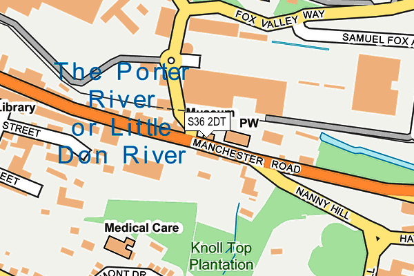
S36 2DT is located in the Stocksbridge and Upper Don electoral ward, within the metropolitan district of Sheffield and the English Parliamentary constituency of Penistone and Stocksbridge. The Sub Integrated Care Board (ICB) Location is NHS South Yorkshire ICB - 03N and the police force is South Yorkshire. This postcode has been in use since June 1997.


GetTheData
Source: OS OpenMap – Local (Ordnance Survey)
Source: OS VectorMap District (Ordnance Survey)
Licence: Open Government Licence (requires attribution)
| Easting | 427339 |
| Northing | 398423 |
| Latitude | 53.481840 |
| Longitude | -1.589506 |
GetTheData
Source: Open Postcode Geo
Licence: Open Government Licence
| Country | England |
| Postcode District | S36 |
| ➜ S36 open data dashboard ➜ See where S36 is on a map ➜ Where is Stocksbridge? | |
GetTheData
Source: Land Registry Price Paid Data
Licence: Open Government Licence
Elevation or altitude of S36 2DT as distance above sea level:
| Metres | Feet | |
|---|---|---|
| Elevation | 160m | 525ft |
Elevation is measured from the approximate centre of the postcode, to the nearest point on an OS contour line from OS Terrain 50, which has contour spacing of ten vertical metres.
➜ How high above sea level am I? Find the elevation of your current position using your device's GPS.
GetTheData
Source: Open Postcode Elevation
Licence: Open Government Licence
| Ward | Stocksbridge And Upper Don |
| Constituency | Penistone And Stocksbridge |
GetTheData
Source: ONS Postcode Database
Licence: Open Government Licence
| June 2022 | Violence and sexual offences | On or near Supermarket | 102m |
| June 2022 | Drugs | On or near Supermarket | 180m |
| June 2022 | Theft from the person | On or near Nanny Hill | 184m |
| ➜ Get more crime data in our Crime section | |||
GetTheData
Source: data.police.uk
Licence: Open Government Licence
| Manchester Road (Fox Valley Way) | Stocksbridge | 47m |
| Hunshelf Road (Manchester Road) | Stocksbridge | 55m |
| Hunshelf Road (Manchester Road) | Stocksbridge | 74m |
| Fox Valley Retail Park (Fox Valley Way) | Stocksbridge | 113m |
| Manchester Road (Nanny Hill) | Stocksbridge | 132m |
| Penistone Station | 5.3km |
GetTheData
Source: NaPTAN
Licence: Open Government Licence
GetTheData
Source: ONS Postcode Database
Licence: Open Government Licence


➜ Get more ratings from the Food Standards Agency
GetTheData
Source: Food Standards Agency
Licence: FSA terms & conditions
| Last Collection | |||
|---|---|---|---|
| Location | Mon-Fri | Sat | Distance |
| Town Hall Manchester Road | 17:45 | 11:35 | 64m |
| Bocking Hill | 18:15 | 08:30 | 369m |
| Shay Road | 18:00 | 08:30 | 461m |
GetTheData
Source: Dracos
Licence: Creative Commons Attribution-ShareAlike
| Facility | Distance |
|---|---|
| Snap Fitness (Stocksbridge) Fox Valley Way, Fox Valley Way, Stocksbridge, Sheffield Health and Fitness Gym | 287m |
| Bracken Moor Stadium Bracken Moor Lane, Sheffield Grass Pitches | 542m |
| Stocksbridge High School Shay House Lane, Stocksbridge, Sheffield Grass Pitches, Sports Hall, Studio | 567m |
GetTheData
Source: Active Places
Licence: Open Government Licence
| School | Phase of Education | Distance |
|---|---|---|
| Stocksbridge High School Shay House Lane, Stocksbridge, Sheffield, S36 1FD | Secondary | 641m |
| St Ann's Catholic Primary School, A Voluntary Academy McIntyre Road, Stocksbridge, Sheffield, S36 1DG | Primary | 692m |
| Stocksbridge Nursery Infant School Pot House Lane, Stocksbridge, Sheffield, S36 1EJ | Primary | 825m |
GetTheData
Source: Edubase
Licence: Open Government Licence
The below table lists the International Territorial Level (ITL) codes (formerly Nomenclature of Territorial Units for Statistics (NUTS) codes) and Local Administrative Units (LAU) codes for S36 2DT:
| ITL 1 Code | Name |
|---|---|
| TLE | Yorkshire and The Humber |
| ITL 2 Code | Name |
| TLE3 | South Yorkshire |
| ITL 3 Code | Name |
| TLE32 | Sheffield |
| LAU 1 Code | Name |
| E08000019 | Sheffield |
GetTheData
Source: ONS Postcode Directory
Licence: Open Government Licence
The below table lists the Census Output Area (OA), Lower Layer Super Output Area (LSOA), and Middle Layer Super Output Area (MSOA) for S36 2DT:
| Code | Name | |
|---|---|---|
| OA | E00041288 | |
| LSOA | E01008144 | Sheffield 001A |
| MSOA | E02001611 | Sheffield 001 |
GetTheData
Source: ONS Postcode Directory
Licence: Open Government Licence
| S36 1DJ | Manchester Road | 32m |
| S36 2DS | Manchester Road | 142m |
| S36 2DU | Manchester Road | 165m |
| S36 1DH | Manchester Road | 207m |
| S36 2BU | Hunshelf Road | 208m |
| S36 1BJ | Edward Street | 226m |
| S36 2BT | Hunshelf Park | 233m |
| S36 1AH | Belmont Drive | 236m |
| S36 1BR | Hope Street | 251m |
| S36 2GQ | Knoll Close | 262m |
GetTheData
Source: Open Postcode Geo; Land Registry Price Paid Data
Licence: Open Government Licence