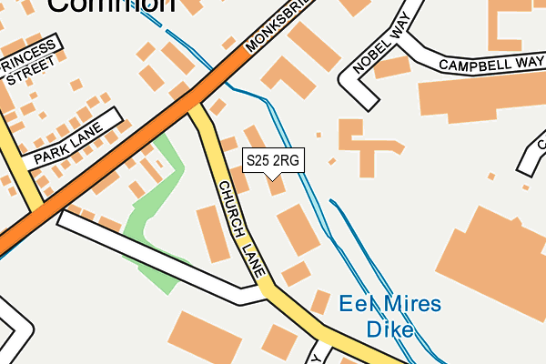
S25 2RG is located in the Dinnington electoral ward, within the metropolitan district of Rotherham and the English Parliamentary constituency of Rother Valley. The Sub Integrated Care Board (ICB) Location is NHS South Yorkshire ICB - 03L and the police force is South Yorkshire. This postcode has been in use since January 2007.


GetTheData
Source: OS OpenMap – Local (Ordnance Survey)
Source: OS VectorMap District (Ordnance Survey)
Licence: Open Government Licence (requires attribution)
| Easting | 451563 |
| Northing | 386489 |
| Latitude | 53.372754 |
| Longitude | -1.226457 |
GetTheData
Source: Open Postcode Geo
Licence: Open Government Licence
| Country | England |
| Postcode District | S25 |
| ➜ S25 open data dashboard ➜ See where S25 is on a map ➜ Where is Dinnington? | |
GetTheData
Source: Land Registry Price Paid Data
Licence: Open Government Licence
Elevation or altitude of S25 2RG as distance above sea level:
| Metres | Feet | |
|---|---|---|
| Elevation | 100m | 328ft |
Elevation is measured from the approximate centre of the postcode, to the nearest point on an OS contour line from OS Terrain 50, which has contour spacing of ten vertical metres.
➜ How high above sea level am I? Find the elevation of your current position using your device's GPS.
GetTheData
Source: Open Postcode Elevation
Licence: Open Government Licence
| Ward | Dinnington |
| Constituency | Rother Valley |
GetTheData
Source: ONS Postcode Database
Licence: Open Government Licence
| June 2022 | Criminal damage and arson | On or near Monksbridge Road | 131m |
| June 2022 | Other theft | On or near Monksbridge Road | 131m |
| June 2022 | Other theft | On or near Nobel Way | 199m |
| ➜ Get more crime data in our Crime section | |||
GetTheData
Source: data.police.uk
Licence: Open Government Licence
| Monksbridge Road (Church Lane) | Dinnington | 49m |
| Monksbridge Road (Church Lane) | Dinnington | 56m |
| Outgang Lane (Monks Bridge Road) | Laughton Common | 169m |
| Outgang Lane (Monks Bridge Road) | Laughton Common | 177m |
| Rotherham Road (Monks Bridge Road) | Laughton Common | 199m |
| Kiveton Park Station | 4.1km |
| Kiveton Bridge Station | 4.5km |
GetTheData
Source: NaPTAN
Licence: Open Government Licence
GetTheData
Source: ONS Postcode Database
Licence: Open Government Licence


➜ Get more ratings from the Food Standards Agency
GetTheData
Source: Food Standards Agency
Licence: FSA terms & conditions
| Last Collection | |||
|---|---|---|---|
| Location | Mon-Fri | Sat | Distance |
| Limelands Road | 17:00 | 11:15 | 604m |
| Laughton Common Post Office | 17:15 | 11:15 | 806m |
| Plantation Avenue | 17:30 | 12:30 | 1,037m |
GetTheData
Source: Dracos
Licence: Creative Commons Attribution-ShareAlike
| Facility | Distance |
|---|---|
| New Pace Fitness Centre (Closed) Outgang Lane, Dinnington, Sheffield Health and Fitness Gym | 330m |
| Hangsman Lane Recreation Ground All Saints Meadows, Laughton Common, Dinnington, Sheffield Grass Pitches | 1km |
| Anston Greenlands Primary School Edinburgh Drive, North Anston, Sheffield Grass Pitches | 1.2km |
GetTheData
Source: Active Places
Licence: Open Government Licence
| School | Phase of Education | Distance |
|---|---|---|
| Anston Greenlands Primary School Edinburgh Drive, North Anston, Sheffield, S25 4HD | Primary | 1.2km |
| Dinnington Community Primary School School Street, Dinnington, Sheffield, S25 2RE | Primary | 1.3km |
| Elements Academy Doe Quarry Lane, Dinnington, Sheffield, S25 2NF | Not applicable | 1.3km |
GetTheData
Source: Edubase
Licence: Open Government Licence
The below table lists the International Territorial Level (ITL) codes (formerly Nomenclature of Territorial Units for Statistics (NUTS) codes) and Local Administrative Units (LAU) codes for S25 2RG:
| ITL 1 Code | Name |
|---|---|
| TLE | Yorkshire and The Humber |
| ITL 2 Code | Name |
| TLE3 | South Yorkshire |
| ITL 3 Code | Name |
| TLE31 | Barnsley, Doncaster and Rotherham |
| LAU 1 Code | Name |
| E08000018 | Rotherham |
GetTheData
Source: ONS Postcode Directory
Licence: Open Government Licence
The below table lists the Census Output Area (OA), Lower Layer Super Output Area (LSOA), and Middle Layer Super Output Area (MSOA) for S25 2RG:
| Code | Name | |
|---|---|---|
| OA | E00039435 | |
| LSOA | E01007789 | Rotherham 028C |
| MSOA | E02001605 | Rotherham 028 |
GetTheData
Source: ONS Postcode Directory
Licence: Open Government Licence
| S25 3QS | Monksbridge Road | 141m |
| S25 2LX | Church Lane | 204m |
| S25 3UG | Park Lane | 220m |
| S25 3QZ | Monksbridge Trading Estate | 300m |
| S25 3RE | Princess Street | 311m |
| S25 3QD | Campbell Way | 338m |
| S25 3SJ | Dettori Mews | 342m |
| S25 3RF | Rotherham Road | 359m |
| S25 3QP | Carson Avenue | 360m |
| S25 3QN | Meadow Street | 374m |
GetTheData
Source: Open Postcode Geo; Land Registry Price Paid Data
Licence: Open Government Licence