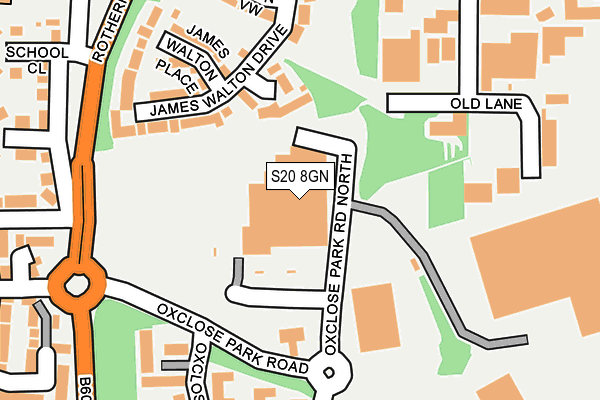
S20 8GN is located in the Mosborough electoral ward, within the metropolitan district of Sheffield and the English Parliamentary constituency of Sheffield South East. The Sub Integrated Care Board (ICB) Location is NHS South Yorkshire ICB - 03N and the police force is South Yorkshire. This postcode has been in use since June 1998.


GetTheData
Source: OS OpenMap – Local (Ordnance Survey)
Source: OS VectorMap District (Ordnance Survey)
Licence: Open Government Licence (requires attribution)
| Easting | 443874 |
| Northing | 381108 |
| Latitude | 53.325100 |
| Longitude | -1.342761 |
GetTheData
Source: Open Postcode Geo
Licence: Open Government Licence
| Country | England |
| Postcode District | S20 |
| ➜ S20 open data dashboard ➜ See where S20 is on a map ➜ Where is Sheffield? | |
GetTheData
Source: Land Registry Price Paid Data
Licence: Open Government Licence
Elevation or altitude of S20 8GN as distance above sea level:
| Metres | Feet | |
|---|---|---|
| Elevation | 60m | 197ft |
Elevation is measured from the approximate centre of the postcode, to the nearest point on an OS contour line from OS Terrain 50, which has contour spacing of ten vertical metres.
➜ How high above sea level am I? Find the elevation of your current position using your device's GPS.
GetTheData
Source: Open Postcode Elevation
Licence: Open Government Licence
| Ward | Mosborough |
| Constituency | Sheffield South East |
GetTheData
Source: ONS Postcode Database
Licence: Open Government Licence
| September 2023 | Anti-social behaviour | On or near Oxclose Park Way | 297m |
| July 2023 | Anti-social behaviour | On or near Oxclose Park Way | 297m |
| July 2023 | Anti-social behaviour | On or near Oxclose Park Way | 297m |
| ➜ Get more crime data in our Crime section | |||
GetTheData
Source: data.police.uk
Licence: Open Government Licence
| Morrisons (Service Road) | Oxclose | 51m |
| School Avenue (Rotherham Road) | Halfway | 223m |
| Station Road (Rotherham Road) | Halfway | 264m |
| Rotherham Road (Station Road) | Halfway | 272m |
| Morton Mount (Rotherham Road) | Halfway | 287m |
| Halfway (Sheffield Supertram) (Eckington Way) | Halfway Tram Stop | 398m |
| Westfield (Sheffield Supertram) (Eckington Way) | Westfield | 758m |
| Waterthorpe (Sheffield Supertram) (Eckington Way) | Waterthorpe | 1,278m |
| Woodhouse Station | 4.4km |
GetTheData
Source: NaPTAN
Licence: Open Government Licence
GetTheData
Source: ONS Postcode Database
Licence: Open Government Licence


➜ Get more ratings from the Food Standards Agency
GetTheData
Source: Food Standards Agency
Licence: FSA terms & conditions
| Last Collection | |||
|---|---|---|---|
| Location | Mon-Fri | Sat | Distance |
| Sewell Road | 17:15 | 11:30 | 273m |
| Station Road | 17:15 | 11:00 | 332m |
| Halfway Delivery Office | 17:15 | 10:30 | 430m |
GetTheData
Source: Dracos
Licence: Creative Commons Attribution-ShareAlike
| Facility | Distance |
|---|---|
| Halfway Junior School Halfway Centre, Sheffield Grass Pitches | 667m |
| Shortbrook Primary School Westfield Northway, Westfield, Sheffield Sports Hall | 738m |
| Evolution Gym & Fitness Carley Drive, Westfield, Sheffield Health and Fitness Gym | 1.1km |
GetTheData
Source: Active Places
Licence: Open Government Licence
| School | Phase of Education | Distance |
|---|---|---|
| Halfway Nursery Infant School Station Road, Halfway, Sheffield, S20 3GU | Primary | 393m |
| Halfway Junior School Halfway Centre, Halfway, Sheffield, S20 4TA | Primary | 665m |
| Shortbrook Primary School Westfield Northway, Westfield, Sheffield, S20 8FB | Primary | 709m |
GetTheData
Source: Edubase
Licence: Open Government Licence
The below table lists the International Territorial Level (ITL) codes (formerly Nomenclature of Territorial Units for Statistics (NUTS) codes) and Local Administrative Units (LAU) codes for S20 8GN:
| ITL 1 Code | Name |
|---|---|
| TLE | Yorkshire and The Humber |
| ITL 2 Code | Name |
| TLE3 | South Yorkshire |
| ITL 3 Code | Name |
| TLE32 | Sheffield |
| LAU 1 Code | Name |
| E08000019 | Sheffield |
GetTheData
Source: ONS Postcode Directory
Licence: Open Government Licence
The below table lists the Census Output Area (OA), Lower Layer Super Output Area (LSOA), and Middle Layer Super Output Area (MSOA) for S20 8GN:
| Code | Name | |
|---|---|---|
| OA | E00172402 | |
| LSOA | E01008023 | Sheffield 072B |
| MSOA | E02006803 | Sheffield 072 |
GetTheData
Source: ONS Postcode Directory
Licence: Open Government Licence
| S20 3GN | James Walton Drive | 161m |
| S20 8GR | Oxclose Park Gardens | 205m |
| S20 3GP | James Walton Place | 213m |
| S20 3GQ | James Walton View | 227m |
| S20 3GY | James Walton Court | 234m |
| S20 8GQ | Oxclose Park View | 243m |
| S20 8GL | Rotherham Road | 256m |
| S20 8GH | Morton Mount | 284m |
| S20 3GS | Station Road | 295m |
| S20 8GE | Deveron Road | 302m |
GetTheData
Source: Open Postcode Geo; Land Registry Price Paid Data
Licence: Open Government Licence