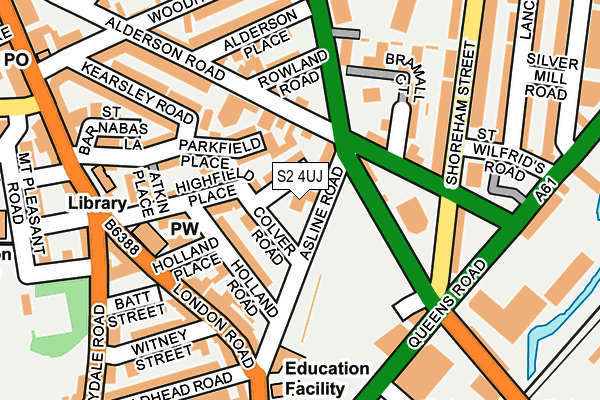
S2 4UJ is located in the Nether Edge and Sharrow electoral ward, within the metropolitan district of Sheffield and the English Parliamentary constituency of Sheffield Central. The Sub Integrated Care Board (ICB) Location is NHS South Yorkshire ICB - 03N and the police force is South Yorkshire. This postcode has been in use since May 1994.


GetTheData
Source: OS OpenMap – Local (Ordnance Survey)
Source: OS VectorMap District (Ordnance Survey)
Licence: Open Government Licence (requires attribution)
| Easting | 435244 |
| Northing | 385655 |
| Latitude | 53.366594 |
| Longitude | -1.471815 |
GetTheData
Source: Open Postcode Geo
Licence: Open Government Licence
| Country | England |
| Postcode District | S2 |
| ➜ S2 open data dashboard ➜ See where S2 is on a map ➜ Where is Sheffield? | |
GetTheData
Source: Land Registry Price Paid Data
Licence: Open Government Licence
Elevation or altitude of S2 4UJ as distance above sea level:
| Metres | Feet | |
|---|---|---|
| Elevation | 70m | 230ft |
Elevation is measured from the approximate centre of the postcode, to the nearest point on an OS contour line from OS Terrain 50, which has contour spacing of ten vertical metres.
➜ How high above sea level am I? Find the elevation of your current position using your device's GPS.
GetTheData
Source: Open Postcode Elevation
Licence: Open Government Licence
| Ward | Nether Edge And Sharrow |
| Constituency | Sheffield Central |
GetTheData
Source: ONS Postcode Database
Licence: Open Government Licence
| January 2024 | Other crime | On or near Thorp Close | 284m |
| January 2024 | Other theft | On or near Parking Area | 298m |
| January 2024 | Public order | On or near Parking Area | 298m |
| ➜ Get more crime data in our Crime section | |||
GetTheData
Source: data.police.uk
Licence: Open Government Licence
| Rowland Road (Bramall Lane) | Highfield | 118m |
| Rowland Road (Bramall Lane) | Highfield | 149m |
| Alderson Road (Shoreham Street) | Lowfield | 154m |
| Highfield Place (London Road) | Highfield | 159m |
| Guernsey Road (Queens Road) | Lowfield | 204m |
| Park Grange Croft (Sheffield Supertram) (Off Park Grange Road) | Norfolk Park | 961m |
| Granville Rd - Sheffield College (Supertram) (Off Granville Road) | Park Hill | 1,113m |
| Park Grange (Sheffield Supertram) (Park Grange Road) | Norfolk Park | 1,120m |
| Sheffield Stn - Hallam Uni (Supertram) (Off Sheaf Street) | Sheffield Centre | 1,434m |
| Sheffield Station | 1.4km |
| Darnall Station | 4.4km |
| Dore & Totley Station | 5.2km |
GetTheData
Source: NaPTAN
Licence: Open Government Licence
GetTheData
Source: ONS Postcode Database
Licence: Open Government Licence


➜ Get more ratings from the Food Standards Agency
GetTheData
Source: Food Standards Agency
Licence: FSA terms & conditions
| Last Collection | |||
|---|---|---|---|
| Location | Mon-Fri | Sat | Distance |
| Asline Road | 17:30 | 12:30 | 24m |
| Highfield Post Office | 18:30 | 12:10 | 297m |
| Randall Street | 18:00 | 12:30 | 351m |
GetTheData
Source: Dracos
Licence: Creative Commons Attribution-ShareAlike
| Facility | Distance |
|---|---|
| U-mix Centre Asline Road, Sheffield Artificial Grass Pitch, Studio, Health and Fitness Gym | 118m |
| Gym Plus (Closed) Bramall Lane, Sheffield Health and Fitness Gym | 301m |
| Jd Gyms (Sheffield South) Guernsey Road, Sheffield Health and Fitness Gym | 349m |
GetTheData
Source: Active Places
Licence: Open Government Licence
| School | Phase of Education | Distance |
|---|---|---|
| Lowfield Community Primary School London Road, Sheffield, S2 4NJ | Primary | 250m |
| Sharrow Nursery, Infant and Junior School Sitwell Road, Sheffield, S7 1BE | Primary | 326m |
| Anns Grove Primary School Anns Road, Sheffield, S2 3DJ | Primary | 632m |
GetTheData
Source: Edubase
Licence: Open Government Licence
The below table lists the International Territorial Level (ITL) codes (formerly Nomenclature of Territorial Units for Statistics (NUTS) codes) and Local Administrative Units (LAU) codes for S2 4UJ:
| ITL 1 Code | Name |
|---|---|
| TLE | Yorkshire and The Humber |
| ITL 2 Code | Name |
| TLE3 | South Yorkshire |
| ITL 3 Code | Name |
| TLE32 | Sheffield |
| LAU 1 Code | Name |
| E08000019 | Sheffield |
GetTheData
Source: ONS Postcode Directory
Licence: Open Government Licence
The below table lists the Census Output Area (OA), Lower Layer Super Output Area (LSOA), and Middle Layer Super Output Area (MSOA) for S2 4UJ:
| Code | Name | |
|---|---|---|
| OA | E00041080 | |
| LSOA | E01008109 | Sheffield 042B |
| MSOA | E02001652 | Sheffield 042 |
GetTheData
Source: ONS Postcode Directory
Licence: Open Government Licence
| S2 4UN | Belgrave Square | 36m |
| S2 4UP | Colver Road | 52m |
| S2 4UT | Holland Road | 79m |
| S2 4TH | Parkfield Place | 84m |
| S2 4UE | Alderson Road | 102m |
| S2 4UF | Alderson Road North | 117m |
| S2 4US | Holland Place | 118m |
| S2 4UR | Highfield Place | 128m |
| S2 4NG | London Road | 134m |
| S2 4UD | Alderson Road | 147m |
GetTheData
Source: Open Postcode Geo; Land Registry Price Paid Data
Licence: Open Government Licence