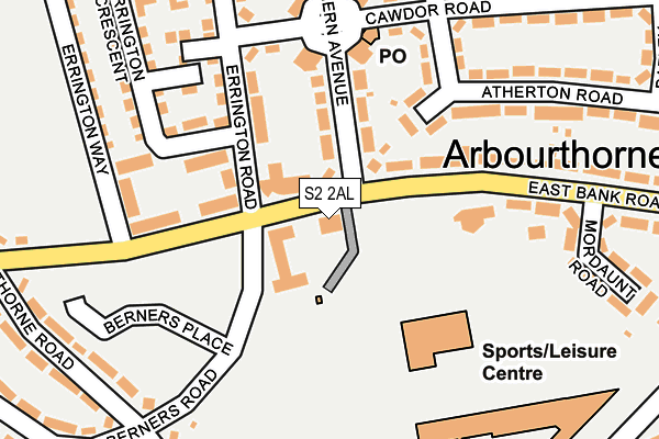
S2 2AL is located in the Park and Arbourthorne electoral ward, within the metropolitan district of Sheffield and the English Parliamentary constituency of Sheffield, Heeley. The Sub Integrated Care Board (ICB) Location is NHS South Yorkshire ICB - 03N and the police force is South Yorkshire. This postcode has been in use since January 1980.


GetTheData
Source: OS OpenMap – Local (Ordnance Survey)
Source: OS VectorMap District (Ordnance Survey)
Licence: Open Government Licence (requires attribution)
| Easting | 437511 |
| Northing | 384745 |
| Latitude | 53.358259 |
| Longitude | -1.437856 |
GetTheData
Source: Open Postcode Geo
Licence: Open Government Licence
| Country | England |
| Postcode District | S2 |
| ➜ S2 open data dashboard ➜ See where S2 is on a map ➜ Where is Sheffield? | |
GetTheData
Source: Land Registry Price Paid Data
Licence: Open Government Licence
Elevation or altitude of S2 2AL as distance above sea level:
| Metres | Feet | |
|---|---|---|
| Elevation | 210m | 689ft |
Elevation is measured from the approximate centre of the postcode, to the nearest point on an OS contour line from OS Terrain 50, which has contour spacing of ten vertical metres.
➜ How high above sea level am I? Find the elevation of your current position using your device's GPS.
GetTheData
Source: Open Postcode Elevation
Licence: Open Government Licence
| Ward | Park And Arbourthorne |
| Constituency | Sheffield, Heeley |
GetTheData
Source: ONS Postcode Database
Licence: Open Government Licence
| January 2024 | Violence and sexual offences | On or near Aylward Road | 356m |
| December 2023 | Burglary | On or near Aylward Road | 356m |
| December 2023 | Violence and sexual offences | On or near Berners Road | 404m |
| ➜ Get more crime data in our Crime section | |||
GetTheData
Source: data.police.uk
Licence: Open Government Licence
| Errington Road (East Bank Road) | Arbourthorne | 29m |
| East Bank Road (Northern Avenue) | Arbourthorne | 79m |
| Northern Avenue (East Bank Road) | Arbourthorne | 101m |
| Arbourthorne Road (East Bank Road) | Arbourthorne | 213m |
| Cawdor Road (Northern Avenue) | Arbourthorne | 233m |
| Manor Top - Elm Tree (Sheffield Supertram) (Off Ridgeway Road) | Manor Top | 633m |
| Arbourthorne Road (Sheffield Supertram) (Park Grange Road) | Norfolk Park | 887m |
| Spring Lane (Sheffield Supertram) (Park Grange Road) | Fairleigh | 894m |
| Hollinsend (Sheffield Supertram) (Ridgeway Road) | Gleadless | 1,125m |
| Park Grange (Sheffield Supertram) (Park Grange Road) | Norfolk Park | 1,508m |
| Sheffield Station | 2.7km |
| Darnall Station | 3.4km |
GetTheData
Source: NaPTAN
Licence: Open Government Licence
GetTheData
Source: ONS Postcode Database
Licence: Open Government Licence


➜ Get more ratings from the Food Standards Agency
GetTheData
Source: Food Standards Agency
Licence: FSA terms & conditions
| Last Collection | |||
|---|---|---|---|
| Location | Mon-Fri | Sat | Distance |
| Northern Avenue Post Office | 17:30 | 12:00 | 180m |
| 166 Gleadless Common | 17:30 | 09:30 | 583m |
| Ridgeway Road | 17:30 | 09:30 | 606m |
GetTheData
Source: Dracos
Licence: Creative Commons Attribution-ShareAlike
| Facility | Distance |
|---|---|
| Springs Leisure Centre East Bank Road, Sheffield Sports Hall, Swimming Pool, Health and Fitness Gym, Studio, Artificial Grass Pitch | 137m |
| Sheffield Springs Academy Hurlfield Road, Sheffield Sports Hall, Grass Pitches, Artificial Grass Pitch | 245m |
| In Trim Health & Fitness Ridgeway Road, Sheffield Health and Fitness Gym | 615m |
GetTheData
Source: Active Places
Licence: Open Government Licence
| School | Phase of Education | Distance |
|---|---|---|
| Sheffield Springs Academy Hurlfield Road, Sheffield, S12 2SF | Secondary | 397m |
| Arbourthorne Community Primary School Eastern Avenue, Sheffield, S2 2GQ | Primary | 698m |
| Prince Edward Primary School Queen Mary Road, Sheffield, S2 1EE | Primary | 775m |
GetTheData
Source: Edubase
Licence: Open Government Licence
The below table lists the International Territorial Level (ITL) codes (formerly Nomenclature of Territorial Units for Statistics (NUTS) codes) and Local Administrative Units (LAU) codes for S2 2AL:
| ITL 1 Code | Name |
|---|---|
| TLE | Yorkshire and The Humber |
| ITL 2 Code | Name |
| TLE3 | South Yorkshire |
| ITL 3 Code | Name |
| TLE32 | Sheffield |
| LAU 1 Code | Name |
| E08000019 | Sheffield |
GetTheData
Source: ONS Postcode Directory
Licence: Open Government Licence
The below table lists the Census Output Area (OA), Lower Layer Super Output Area (LSOA), and Middle Layer Super Output Area (MSOA) for S2 2AL:
| Code | Name | |
|---|---|---|
| OA | E00041050 | |
| LSOA | E01008102 | Sheffield 048C |
| MSOA | E02001658 | Sheffield 048 |
GetTheData
Source: ONS Postcode Directory
Licence: Open Government Licence
| S2 2EJ | Northern Avenue | 99m |
| S2 2ET | Atherton Close | 111m |
| S2 2EG | Errington Road | 150m |
| S2 2EP | Cawdor Road | 166m |
| S2 2AF | East Bank Road | 199m |
| S2 2EF | Errington Road | 206m |
| S2 2ER | Atherton Road | 226m |
| S2 2AH | East Bank Road | 228m |
| S2 2ES | Atherton Road | 247m |
| S2 2EH | Northern Avenue | 251m |
GetTheData
Source: Open Postcode Geo; Land Registry Price Paid Data
Licence: Open Government Licence