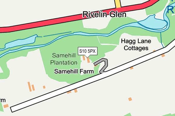
S10 5PX lies on Bell Hagg in Sheffield. S10 5PX is located in the Crookes and Crosspool electoral ward, within the metropolitan district of Sheffield and the English Parliamentary constituency of Sheffield, Hallam. The Sub Integrated Care Board (ICB) Location is NHS South Yorkshire ICB - 03N and the police force is South Yorkshire. This postcode has been in use since January 1980.


GetTheData
Source: OS OpenMap – Local (Ordnance Survey)
Source: OS VectorMap District (Ordnance Survey)
Licence: Open Government Licence (requires attribution)
| Easting | 430652 |
| Northing | 387463 |
| Latitude | 53.383130 |
| Longitude | -1.540647 |
GetTheData
Source: Open Postcode Geo
Licence: Open Government Licence
| Street | Bell Hagg |
| Town/City | Sheffield |
| Country | England |
| Postcode District | S10 |
| ➜ S10 open data dashboard ➜ See where S10 is on a map | |
GetTheData
Source: Land Registry Price Paid Data
Licence: Open Government Licence
Elevation or altitude of S10 5PX as distance above sea level:
| Metres | Feet | |
|---|---|---|
| Elevation | 130m | 427ft |
Elevation is measured from the approximate centre of the postcode, to the nearest point on an OS contour line from OS Terrain 50, which has contour spacing of ten vertical metres.
➜ How high above sea level am I? Find the elevation of your current position using your device's GPS.
GetTheData
Source: Open Postcode Elevation
Licence: Open Government Licence
| Ward | Crookes And Crosspool |
| Constituency | Sheffield, Hallam |
GetTheData
Source: ONS Postcode Database
Licence: Open Government Licence
| February 2022 | Violence and sexual offences | On or near Tofts Lane | 351m |
| February 2022 | Violence and sexual offences | On or near Tofts Lane | 351m |
| August 2021 | Vehicle crime | On or near Manchester Road | 313m |
| ➜ Get more crime data in our Crime section | |||
GetTheData
Source: data.police.uk
Licence: Open Government Licence
| Tofts Lane (Rivelin Valley Road) | Rivelin | 192m |
| Tofts Lane (Rivelin Valley Road) | Rivelin | 192m |
| Den Bank Avenue (Manchester Road) | Crosspool | 330m |
| Den Bank Avenue (Manchester Road) | Crosspool | 338m |
| Wolf Wheel Car Park (Rivelin Valley Road) | Rivelin | 418m |
GetTheData
Source: NaPTAN
Licence: Open Government Licence
| Percentage of properties with Next Generation Access | 100.0% |
| Percentage of properties with Superfast Broadband | 0.0% |
| Percentage of properties with Ultrafast Broadband | 0.0% |
| Percentage of properties with Full Fibre Broadband | 0.0% |
Superfast Broadband is between 30Mbps and 300Mbps
Ultrafast Broadband is > 300Mbps
| Percentage of properties unable to receive 2Mbps | 0.0% |
| Percentage of properties unable to receive 5Mbps | 80.0% |
| Percentage of properties unable to receive 10Mbps | 100.0% |
| Percentage of properties unable to receive 30Mbps | 100.0% |
GetTheData
Source: Ofcom
Licence: Ofcom Terms of Use (requires attribution)
GetTheData
Source: ONS Postcode Database
Licence: Open Government Licence


➜ Get more ratings from the Food Standards Agency
GetTheData
Source: Food Standards Agency
Licence: FSA terms & conditions
| Last Collection | |||
|---|---|---|---|
| Location | Mon-Fri | Sat | Distance |
| 24 Moorbank Road | 18:00 | 09:30 | 515m |
| 630 Manchester Road | 18:00 | 09:30 | 685m |
| Sandygate Park | 18:00 | 09:30 | 763m |
GetTheData
Source: Dracos
Licence: Creative Commons Attribution-ShareAlike
| Facility | Distance |
|---|---|
| Crosspool District Youth Sports Trust Sandygate Grange Drive, Sheffield Sports Hall, Grass Pitches, Outdoor Tennis Courts | 772m |
| Hallamshire Golf Club Redmires Road, Sheffield Golf | 918m |
| The Sandygate Ground Sandygate Road, Sheffield Grass Pitches | 1km |
GetTheData
Source: Active Places
Licence: Open Government Licence
| School | Phase of Education | Distance |
|---|---|---|
| Hallam Primary School Hallam Grange Crescent, Sheffield, S10 4BD | Primary | 1.2km |
| Stannington Infant School Stannington Road, Sheffield, S6 6AN | Primary | 1.3km |
| Tapton School Darwin Lane, Sheffield, S10 5RG | Secondary | 1.6km |
GetTheData
Source: Edubase
Licence: Open Government Licence
The below table lists the International Territorial Level (ITL) codes (formerly Nomenclature of Territorial Units for Statistics (NUTS) codes) and Local Administrative Units (LAU) codes for S10 5PX:
| ITL 1 Code | Name |
|---|---|
| TLE | Yorkshire and The Humber |
| ITL 2 Code | Name |
| TLE3 | South Yorkshire |
| ITL 3 Code | Name |
| TLE32 | Sheffield |
| LAU 1 Code | Name |
| E08000019 | Sheffield |
GetTheData
Source: ONS Postcode Directory
Licence: Open Government Licence
The below table lists the Census Output Area (OA), Lower Layer Super Output Area (LSOA), and Middle Layer Super Output Area (MSOA) for S10 5PX:
| Code | Name | |
|---|---|---|
| OA | E00040308 | |
| LSOA | E01007961 | Sheffield 033D |
| MSOA | E02001643 | Sheffield 033 |
GetTheData
Source: ONS Postcode Directory
Licence: Open Government Licence
| S6 5SL | Tofts Lane | 297m |
| S6 5SB | Roscoe Bank | 331m |
| S10 5TR | Moorbank Road | 465m |
| S10 5PU | Manchester Road | 501m |
| S10 5TQ | Moorbank Road | 529m |
| S6 5SG | Rivelin Valley Road | 531m |
| S10 5TU | Burnt Stones Grove | 550m |
| S10 5TP | Moorbank Close | 550m |
| S10 5TS | Burnt Stones Close | 556m |
| S10 5TT | Burnt Stones Drive | 571m |
GetTheData
Source: Open Postcode Geo; Land Registry Price Paid Data
Licence: Open Government Licence