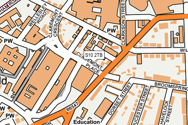
S10 2TB is located in the Broomhill and Sharrow Vale electoral ward, within the metropolitan district of Sheffield and the English Parliamentary constituency of Sheffield Central. The Sub Integrated Care Board (ICB) Location is NHS South Yorkshire ICB - 03N and the police force is South Yorkshire. This postcode has been in use since January 1980.


GetTheData
Source: OS OpenMap – Local (Ordnance Survey)
Source: OS VectorMap District (Ordnance Survey)
Licence: Open Government Licence (requires attribution)
| Easting | 433975 |
| Northing | 387017 |
| Latitude | 53.378937 |
| Longitude | -1.490738 |
GetTheData
Source: Open Postcode Geo
Licence: Open Government Licence
| Country | England |
| Postcode District | S10 |
| ➜ S10 open data dashboard ➜ See where S10 is on a map ➜ Where is Sheffield? | |
GetTheData
Source: Land Registry Price Paid Data
Licence: Open Government Licence
Elevation or altitude of S10 2TB as distance above sea level:
| Metres | Feet | |
|---|---|---|
| Elevation | 120m | 394ft |
Elevation is measured from the approximate centre of the postcode, to the nearest point on an OS contour line from OS Terrain 50, which has contour spacing of ten vertical metres.
➜ How high above sea level am I? Find the elevation of your current position using your device's GPS.
GetTheData
Source: Open Postcode Elevation
Licence: Open Government Licence
| Ward | Broomhill And Sharrow Vale |
| Constituency | Sheffield Central |
GetTheData
Source: ONS Postcode Database
Licence: Open Government Licence
| January 2024 | Vehicle crime | On or near Park Crescent | 344m |
| September 2023 | Anti-social behaviour | On or near Park Crescent | 344m |
| May 2023 | Burglary | On or near Park Crescent | 344m |
| ➜ Get more crime data in our Crime section | |||
GetTheData
Source: data.police.uk
Licence: Open Government Licence
| Clarkson Street (Glossop Road) | Western Bank | 158m |
| Clarkson Street (Glossop Road) | Western Bank | 206m |
| Clarkson Street (Durham Road) | Western Bank | 207m |
| Glossop Road (Durham Road) | Western Bank | 216m |
| Childrens Hospital (Western Bank) | Western Bank | 228m |
| University Of Sheffield (Sheffield Supertram) (Hanover Street) | Western Bank | 486m |
| Netherthorpe Road (Sheffield Supertram) (Netherthorpe Road) | Netherthorpe | 846m |
| West Street (Sheffield Supertram) (West Street) | Sheffield Centre | 901m |
| City Hall (Sheffield Supertram) (West Street) | Sheffield Centre | 1,231m |
| Shalesmoor (Sheffield Supertram) (Corner Of Netherthorpe Rd And Shalesmoor) | Shalesmoor | 1,379m |
| Sheffield Station | 1.9km |
GetTheData
Source: NaPTAN
Licence: Open Government Licence
GetTheData
Source: ONS Postcode Database
Licence: Open Government Licence


➜ Get more ratings from the Food Standards Agency
GetTheData
Source: Food Standards Agency
Licence: FSA terms & conditions
| Last Collection | |||
|---|---|---|---|
| Location | Mon-Fri | Sat | Distance |
| Glossop Road Post Office | 17:30 | 10:00 | 102m |
| 445 Glossop Road | 18:00 | 09:30 | 288m |
| Jessops Wing | 16:30 | 11:45 | 305m |
GetTheData
Source: Dracos
Licence: Creative Commons Attribution-ShareAlike
| Facility | Distance |
|---|---|
| King Edwards Swimming Pool Clarkehouse Road, Sheffield Swimming Pool | 357m |
| King Edward Vii School (Upper Site) Glossop Road, Sheffield Sports Hall | 467m |
| Sheffield Hallam Active (Collegiate Campus) Collegiate Crescent, Sheffield Sports Hall, Health and Fitness Gym, Studio, Squash Courts, Artificial Grass Pitch | 514m |
GetTheData
Source: Active Places
Licence: Open Government Licence
| School | Phase of Education | Distance |
|---|---|---|
| University of Sheffield Western Bank, Sheffield, S10 2TN | Not applicable | 306m |
| King Edward VII School Glossop Road, Sheffield, S10 2PW | Secondary | 449m |
| Broomhall Nursery School 4 Broomhall Road, Sheffield, S10 2DN | Nursery | 509m |
GetTheData
Source: Edubase
Licence: Open Government Licence
The below table lists the International Territorial Level (ITL) codes (formerly Nomenclature of Territorial Units for Statistics (NUTS) codes) and Local Administrative Units (LAU) codes for S10 2TB:
| ITL 1 Code | Name |
|---|---|
| TLE | Yorkshire and The Humber |
| ITL 2 Code | Name |
| TLE3 | South Yorkshire |
| ITL 3 Code | Name |
| TLE32 | Sheffield |
| LAU 1 Code | Name |
| E08000019 | Sheffield |
GetTheData
Source: ONS Postcode Directory
Licence: Open Government Licence
The below table lists the Census Output Area (OA), Lower Layer Super Output Area (LSOA), and Middle Layer Super Output Area (MSOA) for S10 2TB:
| Code | Name | |
|---|---|---|
| OA | E00039802 | |
| LSOA | E01007860 | Sheffield 036B |
| MSOA | E02001646 | Sheffield 036 |
GetTheData
Source: ONS Postcode Directory
Licence: Open Government Licence
| S10 2TD | Shearwood Road | 31m |
| S10 2TE | Palmerston Road | 84m |
| S10 2HP | Glossop Road | 86m |
| S10 2FE | Broomspring Lane | 112m |
| S10 2TT | Northumberland Road | 138m |
| S10 2FW | Dorset Street | 163m |
| S10 2FT | Gloucester Street | 200m |
| S10 2GJ | Wilkinson Street | 200m |
| S10 2SY | Wellesley Road | 226m |
| S10 2HL | Glossop Road | 229m |
GetTheData
Source: Open Postcode Geo; Land Registry Price Paid Data
Licence: Open Government Licence