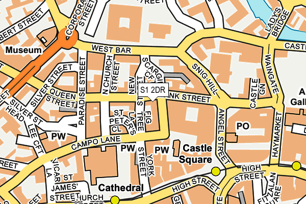
S1 2DR is located in the City electoral ward, within the metropolitan district of Sheffield and the English Parliamentary constituency of Sheffield Central. The Sub Integrated Care Board (ICB) Location is NHS South Yorkshire ICB - 03N and the police force is South Yorkshire. This postcode has been in use since January 1980.


GetTheData
Source: OS OpenMap – Local (Ordnance Survey)
Source: OS VectorMap District (Ordnance Survey)
Licence: Open Government Licence (requires attribution)
| Easting | 435490 |
| Northing | 387629 |
| Latitude | 53.384338 |
| Longitude | -1.467897 |
GetTheData
Source: Open Postcode Geo
Licence: Open Government Licence
| Country | England |
| Postcode District | S1 |
| ➜ S1 open data dashboard ➜ See where S1 is on a map ➜ Where is Sheffield? | |
GetTheData
Source: Land Registry Price Paid Data
Licence: Open Government Licence
Elevation or altitude of S1 2DR as distance above sea level:
| Metres | Feet | |
|---|---|---|
| Elevation | 60m | 197ft |
Elevation is measured from the approximate centre of the postcode, to the nearest point on an OS contour line from OS Terrain 50, which has contour spacing of ten vertical metres.
➜ How high above sea level am I? Find the elevation of your current position using your device's GPS.
GetTheData
Source: Open Postcode Elevation
Licence: Open Government Licence
| Ward | City |
| Constituency | Sheffield Central |
GetTheData
Source: ONS Postcode Database
Licence: Open Government Licence
| December 2023 | Violence and sexual offences | On or near Parking Area | 215m |
| November 2023 | Public order | On or near Spring Street | 241m |
| September 2023 | Public order | On or near Parking Area | 215m |
| ➜ Get more crime data in our Crime section | |||
GetTheData
Source: data.police.uk
Licence: Open Government Licence
| Cg6 (Snig Hill) | Sheffield Centre | 103m |
| Cg5 (Snig Hill) | Sheffield Centre | 105m |
| Paradise Street (Queen Street) | Sheffield Centre | 121m |
| Cg9 (Snig Hill) | Sheffield Centre | 124m |
| Cg4 (Angel Street) | Sheffield Centre | 129m |
| Castle Square (Sheffield Supertram) (Jct Of Arundel Gate And Angel Street) | Sheffield Centre | 183m |
| Cathedral (Sheffield Supertram) (Church Street) | Sheffield Centre | 208m |
| Fitzalan Sq - Ponds Forge (Sheffield Supertram) (Commercial Street) | Sheffield Centre | 296m |
| City Hall (Sheffield Supertram) (West Street) | Sheffield Centre | 436m |
| West Street (Sheffield Supertram) (West Street) | Sheffield Centre | 763m |
| Sheffield Station | 0.8km |
| Darnall Station | 3.7km |
| Meadowhall Station | 5.2km |
GetTheData
Source: NaPTAN
Licence: Open Government Licence
GetTheData
Source: ONS Postcode Database
Licence: Open Government Licence


➜ Get more ratings from the Food Standards Agency
GetTheData
Source: Food Standards Agency
Licence: FSA terms & conditions
| Last Collection | |||
|---|---|---|---|
| Location | Mon-Fri | Sat | Distance |
| Bank Street | 18:30 | 10:00 | 13m |
| Bank Street | 18:30 | 10:00 | 14m |
| Hartshead | 18:30 | 10:00 | 70m |
GetTheData
Source: Dracos
Licence: Creative Commons Attribution-ShareAlike
| Facility | Distance |
|---|---|
| Reviva Health Club For Women (Sheffield) (Closed) King Street, Sheffield Studio, Health and Fitness Gym | 200m |
| Anytime Fitness (Sheffield) Tenter Street, Sheffield Health and Fitness Gym, Studio | 347m |
| Ponds Forge International Sports Centre Sheaf Street, Sheffield Sports Hall, Swimming Pool, Health and Fitness Gym, Studio | 435m |
GetTheData
Source: Active Places
Licence: Open Government Licence
| School | Phase of Education | Distance |
|---|---|---|
| Sheffield Hallam University City Campus, Pond Street, Sheffield, S1 1WB | Not applicable | 503m |
| Grace Owen Nursery School 1-7 the Pavement, Duke Street, Park Hill, Sheffield, S2 5QD | Nursery | 694m |
| Freeman College Sterling Works, 88 Arundel Street, Sheffield, S1 2NG | Not applicable | 783m |
GetTheData
Source: Edubase
Licence: Open Government Licence
The below table lists the International Territorial Level (ITL) codes (formerly Nomenclature of Territorial Units for Statistics (NUTS) codes) and Local Administrative Units (LAU) codes for S1 2DR:
| ITL 1 Code | Name |
|---|---|
| TLE | Yorkshire and The Humber |
| ITL 2 Code | Name |
| TLE3 | South Yorkshire |
| ITL 3 Code | Name |
| TLE32 | Sheffield |
| LAU 1 Code | Name |
| E08000019 | Sheffield |
GetTheData
Source: ONS Postcode Directory
Licence: Open Government Licence
The below table lists the Census Output Area (OA), Lower Layer Super Output Area (LSOA), and Middle Layer Super Output Area (MSOA) for S1 2DR:
| Code | Name | |
|---|---|---|
| OA | E00172419 | |
| LSOA | E01033262 | Sheffield 073B |
| MSOA | E02006843 | Sheffield 073 |
GetTheData
Source: ONS Postcode Directory
Licence: Open Government Licence
| S1 2DJ | Figtree Lane | 44m |
| S1 2DS | Bank Street | 47m |
| S1 2EN | St Peters Close | 73m |
| S1 2EJ | St Peters Close | 75m |
| S1 2EL | Hartshead | 79m |
| S3 8PQ | West Bar | 84m |
| S1 2EF | Campo Lane | 119m |
| S1 2DW | Queen Street | 126m |
| S1 2DF | Paradise Street | 135m |
| S1 2EP | High Court | 142m |
GetTheData
Source: Open Postcode Geo; Land Registry Price Paid Data
Licence: Open Government Licence