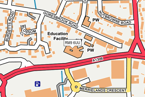
RM9 6UU is located in the Goresbrook electoral ward, within the London borough of Barking and Dagenham and the English Parliamentary constituency of Barking. The Sub Integrated Care Board (ICB) Location is NHS North East London ICB - A3A8R and the police force is Metropolitan Police. This postcode has been in use since January 1980.


GetTheData
Source: OS OpenMap – Local (Ordnance Survey)
Source: OS VectorMap District (Ordnance Survey)
Licence: Open Government Licence (requires attribution)
| Easting | 548837 |
| Northing | 183622 |
| Latitude | 51.531893 |
| Longitude | 0.144386 |
GetTheData
Source: Open Postcode Geo
Licence: Open Government Licence
| Country | England |
| Postcode District | RM9 |
➜ See where RM9 is on a map | |
GetTheData
Source: Land Registry Price Paid Data
Licence: Open Government Licence
Elevation or altitude of RM9 6UU as distance above sea level:
| Metres | Feet | |
|---|---|---|
| Elevation | 10m | 33ft |
Elevation is measured from the approximate centre of the postcode, to the nearest point on an OS contour line from OS Terrain 50, which has contour spacing of ten vertical metres.
➜ How high above sea level am I? Find the elevation of your current position using your device's GPS.
GetTheData
Source: Open Postcode Elevation
Licence: Open Government Licence
| Ward | Goresbrook |
| Constituency | Barking |
GetTheData
Source: ONS Postcode Database
Licence: Open Government Licence
| Chequers Ln Merrilands Ret Pk | Dagenham | 139m |
| Chequers Ln Merrilands Ret Pk (Ripple Road) | Dagenham | 168m |
| Dagenham Asda | Dagenham | 195m |
| Merrielands Crescent (New Road) | Dagenham | 250m |
| Merrielands Crescent (New Road) | Dagenham | 275m |
| Dagenham Heathway Underground Station | Dagenham | 1,106m |
| Becontree Underground Station | Dagenham | 1,527m |
| Dagenham East Underground Station | Dagenham East | 2,023m |
| Dagenham Dock Station | 0.7km |
| Rainham (London) Station | 3.6km |
| Chadwell Heath Station | 4.2km |
GetTheData
Source: NaPTAN
Licence: Open Government Licence
GetTheData
Source: ONS Postcode Database
Licence: Open Government Licence


➜ Get more ratings from the Food Standards Agency
GetTheData
Source: Food Standards Agency
Licence: FSA terms & conditions
| Last Collection | |||
|---|---|---|---|
| Location | Mon-Fri | Sat | Distance |
| Goresbrook Road Post Office | 17:00 | 12:00 | 89m |
| Heathway Post Office | 17:15 | 12:00 | 985m |
| Acre Road | 17:00 | 12:00 | 1,285m |
GetTheData
Source: Dracos
Licence: Creative Commons Attribution-ShareAlike
| Risk of RM9 6UU flooding from rivers and sea | Very Low |
| ➜ RM9 6UU flood map | |
GetTheData
Source: Open Flood Risk by Postcode
Licence: Open Government Licence
The below table lists the International Territorial Level (ITL) codes (formerly Nomenclature of Territorial Units for Statistics (NUTS) codes) and Local Administrative Units (LAU) codes for RM9 6UU:
| ITL 1 Code | Name |
|---|---|
| TLI | London |
| ITL 2 Code | Name |
| TLI5 | Outer London - East and North East |
| ITL 3 Code | Name |
| TLI52 | Barking & Dagenham and Havering |
| LAU 1 Code | Name |
| E09000002 | Barking and Dagenham |
GetTheData
Source: ONS Postcode Directory
Licence: Open Government Licence
The below table lists the Census Output Area (OA), Lower Layer Super Output Area (LSOA), and Middle Layer Super Output Area (MSOA) for RM9 6UU:
| Code | Name | |
|---|---|---|
| OA | E00000278 | |
| LSOA | E01000053 | Barking and Dagenham 020A |
| MSOA | E02000021 | Barking and Dagenham 020 |
GetTheData
Source: ONS Postcode Directory
Licence: Open Government Licence
| RM9 6YD | Butteridges Close | 94m |
| RM9 6UX | Goresbrook Road | 127m |
| RM9 6XZ | Burdetts Road | 137m |
| RM9 6UP | Goresbrook Road | 139m |
| RM9 6UL | Coombes Road | 159m |
| RM9 6RT | Chequers Parade | 164m |
| RM9 6NL | Rowdowns Road | 168m |
| RM9 6UR | Goresbrook Road | 178m |
| RM9 6YG | Goresbrook Road | 189m |
| RM9 6YA | Burdetts Road | 201m |
GetTheData
Source: Open Postcode Geo; Land Registry Price Paid Data
Licence: Open Government Licence