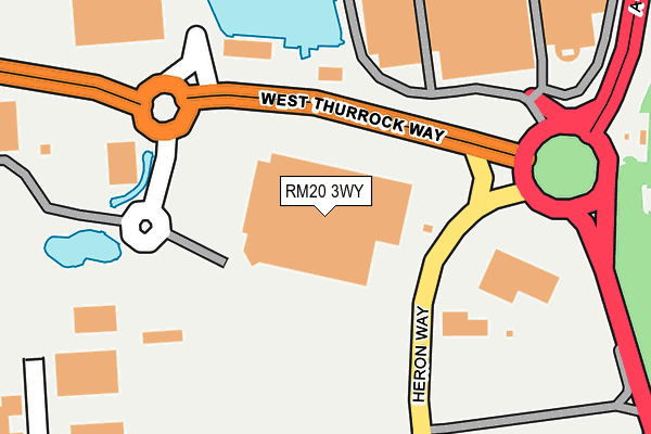
RM20 3WY is located in the West Thurrock and South Stifford electoral ward, within the unitary authority of Thurrock and the English Parliamentary constituency of Thurrock. The Sub Integrated Care Board (ICB) Location is NHS Mid and South Essex ICB - 07G and the police force is Essex. This postcode has been in use since July 1995.


GetTheData
Source: OS OpenMap – Local (Ordnance Survey)
Source: OS VectorMap District (Ordnance Survey)
Licence: Open Government Licence (requires attribution)
| Easting | 558545 |
| Northing | 178472 |
| Latitude | 51.482983 |
| Longitude | 0.281917 |
GetTheData
Source: Open Postcode Geo
Licence: Open Government Licence
| Country | England |
| Postcode District | RM20 |
➜ See where RM20 is on a map ➜ Where is West Thurrock? | |
GetTheData
Source: Land Registry Price Paid Data
Licence: Open Government Licence
Elevation or altitude of RM20 3WY as distance above sea level:
| Metres | Feet | |
|---|---|---|
| Elevation | 0m | 0ft |
Elevation is measured from the approximate centre of the postcode, to the nearest point on an OS contour line from OS Terrain 50, which has contour spacing of ten vertical metres.
➜ How high above sea level am I? Find the elevation of your current position using your device's GPS.
GetTheData
Source: Open Postcode Elevation
Licence: Open Government Licence
| Ward | West Thurrock And South Stifford |
| Constituency | Thurrock |
GetTheData
Source: ONS Postcode Database
Licence: Open Government Licence
| Heron Way | West Thurrock | 116m |
| Costco Roundabout (West Thurrock Way) | Lakeside | 252m |
| Heron Way | Lakeside | 276m |
| Motherwell Way Tis Rental (Motherwell Way) | West Thurrock | 375m |
| Motherwell Way Tis Rental (Motherwell Way) | West Thurrock | 419m |
| Chafford Hundred Station | 0.5km |
| Grays Station | 2.9km |
| Purfleet Station | 3.1km |
GetTheData
Source: NaPTAN
Licence: Open Government Licence
Estimated total energy consumption in RM20 3WY by fuel type, 2015.
| Consumption (kWh) | 77,123 |
|---|---|
| Meter count | 6 |
| Mean (kWh/meter) | 12,854 |
| Median (kWh/meter) | 5,734 |
GetTheData
Source: Postcode level gas estimates: 2015 (experimental)
Source: Postcode level electricity estimates: 2015 (experimental)
Licence: Open Government Licence
GetTheData
Source: ONS Postcode Database
Licence: Open Government Licence


➜ Get more ratings from the Food Standards Agency
GetTheData
Source: Food Standards Agency
Licence: FSA terms & conditions
| Last Collection | |||
|---|---|---|---|
| Location | Mon-Fri | Sat | Distance |
| Tesco Lakeside | 18:30 | 11:30 | 769m |
| Watts Wood | 17:45 | 12:00 | 1,686m |
| Drake Road | 18:30 | 12:00 | 1,766m |
GetTheData
Source: Dracos
Licence: Creative Commons Attribution-ShareAlike
| Risk of RM20 3WY flooding from rivers and sea | Very Low |
| ➜ RM20 3WY flood map | |
GetTheData
Source: Open Flood Risk by Postcode
Licence: Open Government Licence
The below table lists the International Territorial Level (ITL) codes (formerly Nomenclature of Territorial Units for Statistics (NUTS) codes) and Local Administrative Units (LAU) codes for RM20 3WY:
| ITL 1 Code | Name |
|---|---|
| TLH | East |
| ITL 2 Code | Name |
| TLH3 | Essex |
| ITL 3 Code | Name |
| TLH32 | Thurrock |
| LAU 1 Code | Name |
| E06000034 | Thurrock |
GetTheData
Source: ONS Postcode Directory
Licence: Open Government Licence
The below table lists the Census Output Area (OA), Lower Layer Super Output Area (LSOA), and Middle Layer Super Output Area (MSOA) for RM20 3WY:
| Code | Name | |
|---|---|---|
| OA | E00080967 | |
| LSOA | E01016011 | Thurrock 015B |
| MSOA | E02003310 | Thurrock 015 |
GetTheData
Source: ONS Postcode Directory
Licence: Open Government Licence
| RM20 3XD | Trading Estate | 396m |
| RM16 6BG | Grenville Road | 431m |
| RM20 2ZN | Thurrock Lakeside Shopping Centre | 467m |
| RM16 6BP | Rawlyn Close | 481m |
| RM16 6BD | Galleon Road | 492m |
| RM16 6AQ | Galleon Road | 527m |
| RM16 6BS | Rawlyn Close | 530m |
| RM16 6BJ | Plymouth Road | 542m |
| RM16 6RU | Parr Close | 551m |
| RM16 6BQ | Parnell Close | 557m |
GetTheData
Source: Open Postcode Geo; Land Registry Price Paid Data
Licence: Open Government Licence