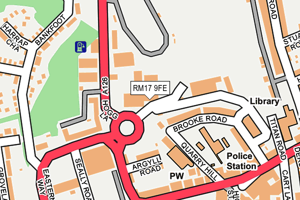
RM17 9FE is located in the Grays Riverside electoral ward, within the unitary authority of Thurrock and the English Parliamentary constituency of Thurrock. The Sub Integrated Care Board (ICB) Location is NHS Mid and South Essex ICB - 07G and the police force is Essex. This postcode has been in use since March 2009.


GetTheData
Source: OS OpenMap – Local (Ordnance Survey)
Source: OS VectorMap District (Ordnance Survey)
Licence: Open Government Licence (requires attribution)
| Easting | 561361 |
| Northing | 178239 |
| Latitude | 51.480094 |
| Longitude | 0.322359 |
GetTheData
Source: Open Postcode Geo
Licence: Open Government Licence
| Country | England |
| Postcode District | RM17 |
| ➜ RM17 open data dashboard ➜ See where RM17 is on a map ➜ Where is Grays? | |
GetTheData
Source: Land Registry Price Paid Data
Licence: Open Government Licence
Elevation or altitude of RM17 9FE as distance above sea level:
| Metres | Feet | |
|---|---|---|
| Elevation | 10m | 33ft |
Elevation is measured from the approximate centre of the postcode, to the nearest point on an OS contour line from OS Terrain 50, which has contour spacing of ten vertical metres.
➜ How high above sea level am I? Find the elevation of your current position using your device's GPS.
GetTheData
Source: Open Postcode Elevation
Licence: Open Government Licence
| Ward | Grays Riverside |
| Constituency | Thurrock |
GetTheData
Source: ONS Postcode Database
Licence: Open Government Licence
| December 2023 | Violence and sexual offences | On or near Kiln Way | 486m |
| December 2023 | Violence and sexual offences | On or near Kiln Way | 486m |
| November 2023 | Violence and sexual offences | On or near Kiln Way | 486m |
| ➜ Get more crime data in our Crime section | |||
GetTheData
Source: data.police.uk
Licence: Open Government Licence
| Stanley Road (Bedford Road) | Grays | 309m |
| Stanley Road | Grays | 327m |
| Hathaway Road | Grays | 328m |
| Hathaway Road | Grays | 347m |
| Clarence Road | Grays | 423m |
| Grays Station | 0.4km |
| Chafford Hundred Station | 2.5km |
| Tilbury Town Station | 3km |
GetTheData
Source: NaPTAN
Licence: Open Government Licence
GetTheData
Source: ONS Postcode Database
Licence: Open Government Licence


➜ Get more ratings from the Food Standards Agency
GetTheData
Source: Food Standards Agency
Licence: FSA terms & conditions
| Last Collection | |||
|---|---|---|---|
| Location | Mon-Fri | Sat | Distance |
| Grays Delivery Office | 19:00 | 13:00 | 162m |
| Orsett Road | 17:30 | 12:30 | 218m |
| Bankfoot/Badgers Dean | 17:30 | 12:00 | 369m |
GetTheData
Source: Dracos
Licence: Creative Commons Attribution-ShareAlike
| Facility | Distance |
|---|---|
| Changes Gym (Closed) High Street, Grays Studio, Health and Fitness Gym | 533m |
| Quarry Hill Academy Bradleigh Avenue, Grays Artificial Grass Pitch | 548m |
| Treetops School (Closed) Dell Road, Grays Sports Hall, Grass Pitches | 562m |
GetTheData
Source: Active Places
Licence: Open Government Licence
| School | Phase of Education | Distance |
|---|---|---|
| Quarry Hill Academy Bradleigh Avenue, Grays, RM17 5UT | Primary | 607m |
| Grays Convent High School College Avenue, Grays, RM17 5UX | Secondary | 617m |
| Thames Park Secondary School Chadwell Road, Grays, RM17 5FP | Secondary | 635m |
GetTheData
Source: Edubase
Licence: Open Government Licence
The below table lists the International Territorial Level (ITL) codes (formerly Nomenclature of Territorial Units for Statistics (NUTS) codes) and Local Administrative Units (LAU) codes for RM17 9FE:
| ITL 1 Code | Name |
|---|---|
| TLH | East |
| ITL 2 Code | Name |
| TLH3 | Essex |
| ITL 3 Code | Name |
| TLH32 | Thurrock |
| LAU 1 Code | Name |
| E06000034 | Thurrock |
GetTheData
Source: ONS Postcode Directory
Licence: Open Government Licence
The below table lists the Census Output Area (OA), Lower Layer Super Output Area (LSOA), and Middle Layer Super Output Area (MSOA) for RM17 9FE:
| Code | Name | |
|---|---|---|
| OA | E00080675 | |
| LSOA | E01015956 | Thurrock 016B |
| MSOA | E02003311 | Thurrock 016 |
GetTheData
Source: ONS Postcode Directory
Licence: Open Government Licence
| RM17 5BN | Brooke Road | 44m |
| RM17 5HT | Cromwell Road | 121m |
| RM17 5BU | Brooke Road | 122m |
| RM17 5BT | Quarry Hill | 131m |
| RM17 5HG | Cromwell Road | 155m |
| RM17 5DD | Orsett Road | 174m |
| RM17 5BS | Argyll Road | 176m |
| RM17 5DS | Orsett Road | 187m |
| RM17 5HQ | Cromwell Road | 208m |
| RM17 5XY | London Road | 209m |
GetTheData
Source: Open Postcode Geo; Land Registry Price Paid Data
Licence: Open Government Licence