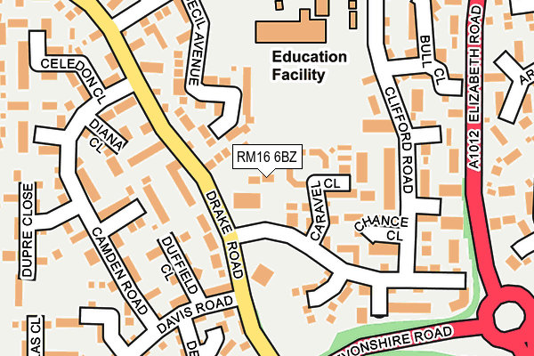
RM16 6BZ is located in the Chafford and North Stifford electoral ward, within the unitary authority of Thurrock and the English Parliamentary constituency of Thurrock. The Sub Integrated Care Board (ICB) Location is NHS Mid and South Essex ICB - 07G and the police force is Essex. This postcode has been in use since December 2000.


GetTheData
Source: OS OpenMap – Local (Ordnance Survey)
Source: OS VectorMap District (Ordnance Survey)
Licence: Open Government Licence (requires attribution)
| Easting | 560719 |
| Northing | 179379 |
| Latitude | 51.490519 |
| Longitude | 0.313611 |
GetTheData
Source: Open Postcode Geo
Licence: Open Government Licence
| Country | England |
| Postcode District | RM16 |
| ➜ RM16 open data dashboard ➜ See where RM16 is on a map ➜ Where is Chafford Hundred? | |
GetTheData
Source: Land Registry Price Paid Data
Licence: Open Government Licence
Elevation or altitude of RM16 6BZ as distance above sea level:
| Metres | Feet | |
|---|---|---|
| Elevation | 30m | 98ft |
Elevation is measured from the approximate centre of the postcode, to the nearest point on an OS contour line from OS Terrain 50, which has contour spacing of ten vertical metres.
➜ How high above sea level am I? Find the elevation of your current position using your device's GPS.
GetTheData
Source: Open Postcode Elevation
Licence: Open Government Licence
| Ward | Chafford And North Stifford |
| Constituency | Thurrock |
GetTheData
Source: ONS Postcode Database
Licence: Open Government Licence
| January 2024 | Burglary | On or near Caravel Close | 69m |
| January 2024 | Drugs | On or near Ark Avenue | 350m |
| January 2024 | Anti-social behaviour | On or near Chester Close | 444m |
| ➜ Get more crime data in our Crime section | |||
GetTheData
Source: data.police.uk
Licence: Open Government Licence
| The Drake Community Centre (Drake Road) | Chafford Hundred | 81m |
| The Drake Community Centre (Drake Road) | Chafford Hundred | 114m |
| Davis Road (Drake Road) | Chafford Hundred | 127m |
| Davis Road (Drake Road) | Chafford Hundred | 165m |
| Elizabeth Road | Grays | 224m |
| Grays Station | 1.7km |
| Chafford Hundred Station | 1.9km |
| Ockendon Station | 3.9km |
GetTheData
Source: NaPTAN
Licence: Open Government Licence
GetTheData
Source: ONS Postcode Database
Licence: Open Government Licence


➜ Get more ratings from the Food Standards Agency
GetTheData
Source: Food Standards Agency
Licence: FSA terms & conditions
| Last Collection | |||
|---|---|---|---|
| Location | Mon-Fri | Sat | Distance |
| Hogg Lane | 16:30 | 12:00 | 393m |
| Drake Road | 18:30 | 12:00 | 680m |
| Nutberry Avenue | 17:00 | 12:00 | 773m |
GetTheData
Source: Dracos
Licence: Creative Commons Attribution-ShareAlike
| Facility | Distance |
|---|---|
| Tudor Court Primary School Bark Burr Road, Grays Grass Pitches | 168m |
| Frobisher Gardens Frobisher Gardens, Chafford Hundred, Grays Grass Pitches | 552m |
| Long Lane Recreation Ground Goddard Road, Grays Grass Pitches | 852m |
GetTheData
Source: Active Places
Licence: Open Government Licence
| School | Phase of Education | Distance |
|---|---|---|
| Tudor Court Primary School Bark Burr Road, Chafford Hundred, Grays, RM16 6PL | Primary | 249m |
| The Hathaway Academy Hathaway Road, Grays, RM17 5LL | Secondary | 1km |
| St Thomas of Canterbury Catholic Primary School Ward Avenue, Grays, RM17 5RW | Primary | 1.2km |
GetTheData
Source: Edubase
Licence: Open Government Licence
The below table lists the International Territorial Level (ITL) codes (formerly Nomenclature of Territorial Units for Statistics (NUTS) codes) and Local Administrative Units (LAU) codes for RM16 6BZ:
| ITL 1 Code | Name |
|---|---|
| TLH | East |
| ITL 2 Code | Name |
| TLH3 | Essex |
| ITL 3 Code | Name |
| TLH32 | Thurrock |
| LAU 1 Code | Name |
| E06000034 | Thurrock |
GetTheData
Source: ONS Postcode Directory
Licence: Open Government Licence
The below table lists the Census Output Area (OA), Lower Layer Super Output Area (LSOA), and Middle Layer Super Output Area (MSOA) for RM16 6BZ:
| Code | Name | |
|---|---|---|
| OA | E00080603 | |
| LSOA | E01033612 | Thurrock 020D |
| MSOA | E02006926 | Thurrock 020 |
GetTheData
Source: ONS Postcode Directory
Licence: Open Government Licence
| RM16 6QB | Caravel Close | 66m |
| RM16 6PA | Duffield Close | 131m |
| RM16 6QA | Cecil Avenue | 131m |
| RM16 6QE | Chance Close | 131m |
| RM16 6QD | Clifford Road | 133m |
| RM16 6NX | Courtenay Drive | 134m |
| RM16 6QF | Clifford Road | 139m |
| RM16 6PU | Diamond Close | 162m |
| RM16 6PX | Diana Close | 162m |
| RM16 6QL | Clifford Road | 182m |
GetTheData
Source: Open Postcode Geo; Land Registry Price Paid Data
Licence: Open Government Licence