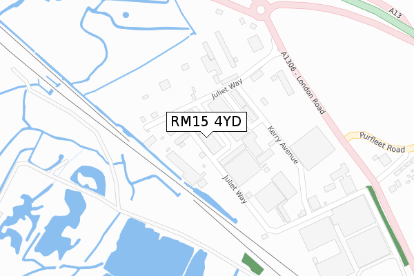
RM15 4YD maps, stats, and open data
RM15 4YD lies on Juliette Way in Purfleet Industrial Park, South Ockendon. RM15 4YD is located in the Aveley and Uplands electoral ward, within the unitary authority of Thurrock and the English Parliamentary constituency of Thurrock. The Sub Integrated Care Board (ICB) Location is NHS Mid and South Essex ICB - 07G and the police force is Essex. This postcode has been in use since April 1987.
RM15 4YD maps


Licence: Open Government Licence (requires attribution)
Attribution: Contains OS data © Crown copyright and database right 2025
Source: Open Postcode Geo
Licence: Open Government Licence (requires attribution)
Attribution: Contains OS data © Crown copyright and database right 2025; Contains Royal Mail data © Royal Mail copyright and database right 2025; Source: Office for National Statistics licensed under the Open Government Licence v.3.0
RM15 4YD geodata
| Easting | 554732 |
| Northing | 179861 |
| Latitude | 51.496518 |
| Longitude | 0.227657 |
Where is RM15 4YD?
| Street | Juliette Way |
| Locality | Purfleet Industrial Park |
| Town/City | South Ockendon |
| Country | England |
| Postcode District | RM15 |
RM15 4YD Elevation
Elevation or altitude of RM15 4YD as distance above sea level:
| Metres | Feet | |
|---|---|---|
| Elevation | 10m | 33ft |
Elevation is measured from the approximate centre of the postcode, to the nearest point on an OS contour line from OS Terrain 50, which has contour spacing of ten vertical metres.
➜ How high above sea level am I? Find the elevation of your current position using your device's GPS.
Politics
| Ward | Aveley And Uplands |
|---|---|
| Constituency | Thurrock |
House Prices
Sales of detached houses in RM15 4YD
ELLISAM HOUSE, JULIETTE WAY, AVELEY, SOUTH OCKENDON, RM15 4YD 2016 7 NOV £361,702 |
UNIT 2 ROMEO INDUSTRIAL CENTRE, 17 - 18, JULIETTE WAY, PURFLEET INDUSTRIAL PARK, SOUTH OCKENDON, RM15 4YD 2005 10 NOV £325,000 |
UNIT 2 ROMEO INDUSTRIAL CENTRE, 17 - 18, JULIETTE WAY, PURFLEET INDUSTRIAL PARK, SOUTH OCKENDON, RM15 4YD 2003 29 MAY £250,000 |
Licence: Contains HM Land Registry data © Crown copyright and database right 2025. This data is licensed under the Open Government Licence v3.0.
Transport
Nearest bus stops to RM15 4YD
| London Road (Purfleet Road) | Aveley | 575m |
| Marlow Avenue (Tank Hill Road) | Purfleet | 1,088m |
| Purfleet Road | Aveley | 1,103m |
| Wennington Hall Farm | Wennington | 1,106m |
| Wennington Hall Farm | Wennington | 1,113m |
Nearest railway stations to RM15 4YD
| Purfleet Station | 1.8km |
| Rainham (London) Station | 3.4km |
| Erith Station | 4km |
Broadband
Broadband speed in RM15 4YD (2019 data)
Download
| Median download speed | 16.7Mbps |
| Average download speed | 20.1Mbps |
| Maximum download speed | 80.00Mbps |
Upload
| Median upload speed | 1.1Mbps |
| Average upload speed | 2.9Mbps |
| Maximum upload speed | 20.00Mbps |
Deprivation
43.8% of English postcodes are less deprived than RM15 4YD:Food Standards Agency
Three nearest food hygiene ratings to RM15 4YD (metres)


➜ Get more ratings from the Food Standards Agency
Nearest post box to RM15 4YD
| Last Collection | |||
|---|---|---|---|
| Location | Mon-Fri | Sat | Distance |
| Purfleet Road | 16:45 | 11:45 | 497m |
| Aveley Post Office | 17:15 | 11:45 | 1,124m |
| Hall Road | 16:45 | 11:45 | 1,677m |
Environment
| Risk of RM15 4YD flooding from rivers and sea | Very Low |
RM15 4YD ITL and RM15 4YD LAU
The below table lists the International Territorial Level (ITL) codes (formerly Nomenclature of Territorial Units for Statistics (NUTS) codes) and Local Administrative Units (LAU) codes for RM15 4YD:
| ITL 1 Code | Name |
|---|---|
| TLH | East |
| ITL 2 Code | Name |
| TLH3 | Essex |
| ITL 3 Code | Name |
| TLH32 | Thurrock |
| LAU 1 Code | Name |
| E06000034 | Thurrock |
RM15 4YD census areas
The below table lists the Census Output Area (OA), Lower Layer Super Output Area (LSOA), and Middle Layer Super Output Area (MSOA) for RM15 4YD:
| Code | Name | |
|---|---|---|
| OA | E00080521 | |
| LSOA | E01015925 | Thurrock 008D |
| MSOA | E02003303 | Thurrock 008 |
Nearest postcodes to RM15 4YD
| RM15 4YG | Thurrock Commercial Centre | 78m |
| RM15 4YA | Thurrock Commercial Centre | 79m |
| RM15 4XT | London Road | 465m |
| RM15 4DT | Purfleet Road | 541m |
| RM15 4XU | London Road | 739m |
| RM15 4DX | Tunnel Cottages | 904m |
| RM15 4XP | Sandy Lane | 964m |
| RM19 1GX | Water Lane | 1054m |
| RM19 1ZU | Centurion Way | 1074m |
| RM19 1GU | Water Lane | 1084m |