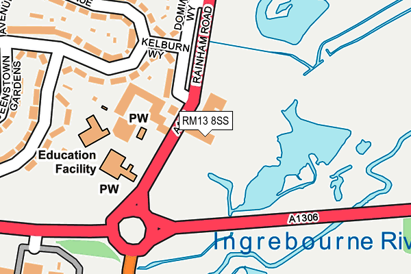
RM13 8SS is located in the Beam Park electoral ward, within the London borough of Havering and the English Parliamentary constituency of Dagenham and Rainham. The Sub Integrated Care Board (ICB) Location is NHS North East London ICB - A3A8R and the police force is Metropolitan Police. This postcode has been in use since January 1980.


GetTheData
Source: OS OpenMap – Local (Ordnance Survey)
Source: OS VectorMap District (Ordnance Survey)
Licence: Open Government Licence (requires attribution)
| Easting | 552154 |
| Northing | 182725 |
| Latitude | 51.522951 |
| Longitude | 0.191812 |
GetTheData
Source: Open Postcode Geo
Licence: Open Government Licence
| Country | England |
| Postcode District | RM13 |
➜ See where RM13 is on a map ➜ Where is London? | |
GetTheData
Source: Land Registry Price Paid Data
Licence: Open Government Licence
Elevation or altitude of RM13 8SS as distance above sea level:
| Metres | Feet | |
|---|---|---|
| Elevation | 10m | 33ft |
Elevation is measured from the approximate centre of the postcode, to the nearest point on an OS contour line from OS Terrain 50, which has contour spacing of ten vertical metres.
➜ How high above sea level am I? Find the elevation of your current position using your device's GPS.
GetTheData
Source: Open Postcode Elevation
Licence: Open Government Licence
| Ward | Beam Park |
| Constituency | Dagenham And Rainham |
GetTheData
Source: ONS Postcode Database
Licence: Open Government Licence
| Dovers Corner | Rainham | 57m |
| Dovers Corner | Rainham | 76m |
| Dovers Corner | Rainham | 268m |
| Knightswood Road (Rainham Road) | Rainham | 329m |
| Knightswood Road (Rainham Road) | Rainham | 354m |
| Rainham (London) Station | 0.7km |
| Dagenham Dock Station | 3.2km |
| Belvedere Station | 4.4km |
GetTheData
Source: NaPTAN
Licence: Open Government Licence
GetTheData
Source: ONS Postcode Database
Licence: Open Government Licence


➜ Get more ratings from the Food Standards Agency
GetTheData
Source: Food Standards Agency
Licence: FSA terms & conditions
| Last Collection | |||
|---|---|---|---|
| Location | Mon-Fri | Sat | Distance |
| Wennington | 17:15 | 12:15 | 834m |
| Fairview Avenue Post Office | 18:30 | 12:00 | 1,059m |
| Acre Road | 17:00 | 12:00 | 2,683m |
GetTheData
Source: Dracos
Licence: Creative Commons Attribution-ShareAlike
| Risk of RM13 8SS flooding from rivers and sea | High |
| ➜ RM13 8SS flood map | |
GetTheData
Source: Open Flood Risk by Postcode
Licence: Open Government Licence
The below table lists the International Territorial Level (ITL) codes (formerly Nomenclature of Territorial Units for Statistics (NUTS) codes) and Local Administrative Units (LAU) codes for RM13 8SS:
| ITL 1 Code | Name |
|---|---|
| TLI | London |
| ITL 2 Code | Name |
| TLI5 | Outer London - East and North East |
| ITL 3 Code | Name |
| TLI52 | Barking & Dagenham and Havering |
| LAU 1 Code | Name |
| E09000016 | Havering |
GetTheData
Source: ONS Postcode Directory
Licence: Open Government Licence
The below table lists the Census Output Area (OA), Lower Layer Super Output Area (LSOA), and Middle Layer Super Output Area (MSOA) for RM13 8SS:
| Code | Name | |
|---|---|---|
| OA | E00011858 | |
| LSOA | E01002370 | Havering 028C |
| MSOA | E02000491 | Havering 028 |
GetTheData
Source: ONS Postcode Directory
Licence: Open Government Licence
| RM13 8HX | Kelburn Way | 129m |
| RM13 8HU | Dominion Way | 160m |
| RM13 8JD | New Zealand Way | 187m |
| RM13 8JX | Dunedin Road | 257m |
| RM13 8JA | Christchurch Avenue | 268m |
| RM13 8JJ | Queenstown Gardens | 283m |
| RM13 8JH | New Zealand Way | 299m |
| RM13 8SZ | Collingwood Road | 309m |
| RM13 8SE | Knightswood Road | 370m |
| RM13 8JT | New Zealand Way | 373m |
GetTheData
Source: Open Postcode Geo; Land Registry Price Paid Data
Licence: Open Government Licence