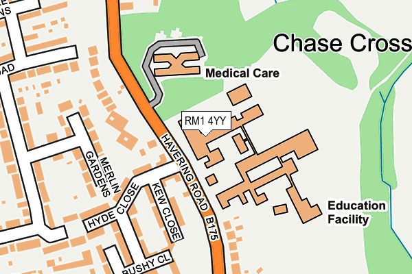
RM1 4YY is located in the Havering-atte-Bower electoral ward, within the London borough of Havering and the English Parliamentary constituency of Romford. The Sub Integrated Care Board (ICB) Location is NHS North East London ICB - A3A8R and the police force is Metropolitan Police. This postcode has been in use since January 1980.


GetTheData
Source: OS OpenMap – Local (Ordnance Survey)
Source: OS VectorMap District (Ordnance Survey)
Licence: Open Government Licence (requires attribution)
| Easting | 551081 |
| Northing | 191923 |
| Latitude | 51.605881 |
| Longitude | 0.180279 |
GetTheData
Source: Open Postcode Geo
Licence: Open Government Licence
| Country | England |
| Postcode District | RM1 |
| ➜ RM1 open data dashboard ➜ See where RM1 is on a map ➜ Where is London? | |
GetTheData
Source: Land Registry Price Paid Data
Licence: Open Government Licence
Elevation or altitude of RM1 4YY as distance above sea level:
| Metres | Feet | |
|---|---|---|
| Elevation | 60m | 197ft |
Elevation is measured from the approximate centre of the postcode, to the nearest point on an OS contour line from OS Terrain 50, which has contour spacing of ten vertical metres.
➜ How high above sea level am I? Find the elevation of your current position using your device's GPS.
GetTheData
Source: Open Postcode Elevation
Licence: Open Government Licence
| Ward | Havering-atte-bower |
| Constituency | Romford |
GetTheData
Source: ONS Postcode Database
Licence: Open Government Licence
| June 2022 | Violence and sexual offences | On or near Kew Close | 121m |
| June 2022 | Anti-social behaviour | On or near Hyde Close | 138m |
| June 2022 | Anti-social behaviour | On or near Hyde Close | 138m |
| ➜ Get more crime data in our Crime section | |||
GetTheData
Source: data.police.uk
Licence: Open Government Licence
| Bower Park School | Chase Cross | 50m |
| Bower Park School | Chase Cross | 115m |
| Chase Cross (Havering Road) | Chase Cross | 158m |
| Chase Cross (Chase Cross Road) | Chase Cross | 230m |
| Chase Cross (Chase Cross Road) | Chase Cross | 252m |
| Gidea Park Station | 3.2km |
| Romford Station | 3.5km |
| Harold Wood Station | 3.9km |
GetTheData
Source: NaPTAN
Licence: Open Government Licence
GetTheData
Source: ONS Postcode Database
Licence: Open Government Licence


➜ Get more ratings from the Food Standards Agency
GetTheData
Source: Food Standards Agency
Licence: FSA terms & conditions
| Last Collection | |||
|---|---|---|---|
| Location | Mon-Fri | Sat | Distance |
| Hillrise Road | 17:00 | 11:45 | 430m |
| Clydeway | 16:45 | 13:00 | 1,142m |
| Carter Drive | 17:00 | 11:30 | 1,258m |
GetTheData
Source: Dracos
Licence: Creative Commons Attribution-ShareAlike
| Facility | Distance |
|---|---|
| Bower Park Academy Havering Road, Romford Sports Hall, Artificial Grass Pitch, Grass Pitches, Studio | 0m |
| Bedfords Park Broxhill Road, Havering-atte-bower, Romford Grass Pitches | 797m |
| Rise Park Infant School Annan Way, Romford Grass Pitches | 1km |
GetTheData
Source: Active Places
Licence: Open Government Licence
| School | Phase of Education | Distance |
|---|---|---|
| Bower Park Academy Havering Road, Romford, RM1 4YY | Secondary | 92m |
| Immanuel School Havering Grange, Havering Road, Romford, RM1 4HR | Not applicable | 381m |
| Rise Park Junior School Annan Way, Rise Park, Romford, RM1 4UD | Primary | 1km |
GetTheData
Source: Edubase
Licence: Open Government Licence
The below table lists the International Territorial Level (ITL) codes (formerly Nomenclature of Territorial Units for Statistics (NUTS) codes) and Local Administrative Units (LAU) codes for RM1 4YY:
| ITL 1 Code | Name |
|---|---|
| TLI | London |
| ITL 2 Code | Name |
| TLI5 | Outer London - East and North East |
| ITL 3 Code | Name |
| TLI52 | Barking & Dagenham and Havering |
| LAU 1 Code | Name |
| E09000016 | Havering |
GetTheData
Source: ONS Postcode Directory
Licence: Open Government Licence
The below table lists the Census Output Area (OA), Lower Layer Super Output Area (LSOA), and Middle Layer Super Output Area (MSOA) for RM1 4YY:
| Code | Name | |
|---|---|---|
| OA | E00011497 | |
| LSOA | E01002304 | Havering 003C |
| MSOA | E02000466 | Havering 003 |
GetTheData
Source: ONS Postcode Directory
Licence: Open Government Licence
| RM1 4HR | Havering Road | 60m |
| RM1 4WG | Hyde Mews | 84m |
| RM1 4WE | Hyde Close | 115m |
| RM1 4HU | Cromwells Mere | 124m |
| RM1 4WF | Hyde Close | 142m |
| RM1 4WJ | Kew Close | 143m |
| RM5 3YD | Merlin Gardens | 190m |
| RM1 4WL | Bushy Close | 190m |
| RM1 4WN | Bushy Close | 203m |
| RM5 3AW | Highfield Road | 251m |
GetTheData
Source: Open Postcode Geo; Land Registry Price Paid Data
Licence: Open Government Licence