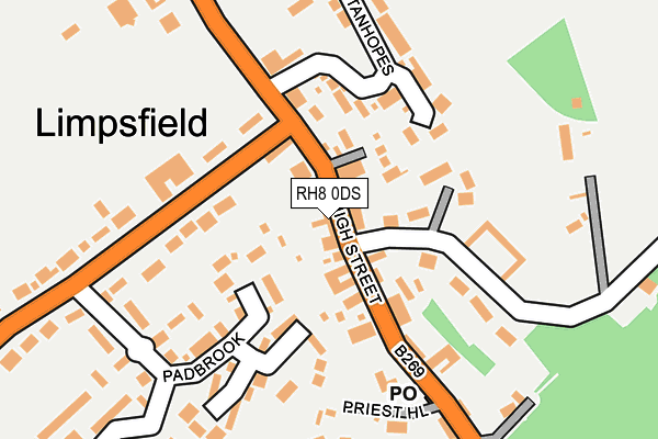
RH8 0DS is located in the Limpsfield electoral ward, within the local authority district of Tandridge and the English Parliamentary constituency of East Surrey. The Sub Integrated Care Board (ICB) Location is NHS Surrey Heartlands ICB - 92A and the police force is Surrey. This postcode has been in use since January 1980.


GetTheData
Source: OS OpenMap – Local (Ordnance Survey)
Source: OS VectorMap District (Ordnance Survey)
Licence: Open Government Licence (requires attribution)
| Easting | 540600 |
| Northing | 153023 |
| Latitude | 51.259039 |
| Longitude | 0.013604 |
GetTheData
Source: Open Postcode Geo
Licence: Open Government Licence
| Country | England |
| Postcode District | RH8 |
| ➜ RH8 open data dashboard ➜ See where RH8 is on a map ➜ Where is Limpsfield? | |
GetTheData
Source: Land Registry Price Paid Data
Licence: Open Government Licence
Elevation or altitude of RH8 0DS as distance above sea level:
| Metres | Feet | |
|---|---|---|
| Elevation | 110m | 361ft |
Elevation is measured from the approximate centre of the postcode, to the nearest point on an OS contour line from OS Terrain 50, which has contour spacing of ten vertical metres.
➜ How high above sea level am I? Find the elevation of your current position using your device's GPS.
GetTheData
Source: Open Postcode Elevation
Licence: Open Government Licence
| Ward | Limpsfield |
| Constituency | East Surrey |
GetTheData
Source: ONS Postcode Database
Licence: Open Government Licence
| November 2023 | Vehicle crime | On or near Detillens Lane | 296m |
| September 2023 | Violence and sexual offences | On or near Detillens Lane | 296m |
| August 2023 | Anti-social behaviour | On or near Detillens Lane | 296m |
| ➜ Get more crime data in our Crime section | |||
GetTheData
Source: data.police.uk
Licence: Open Government Licence
| St Peters Church (High Street) | Limpsfield | 170m |
| St Peters Church (High Street) | Limpsfield | 246m |
| High Street | Limpsfield | 276m |
| High Street | Limpsfield | 295m |
| Titsey Road (Limpsfield Road) | Hookwood | 365m |
| Oxted Station | 1.3km |
| Hurst Green Station | 1.8km |
| Woldingham Station | 5.7km |
GetTheData
Source: NaPTAN
Licence: Open Government Licence
GetTheData
Source: ONS Postcode Database
Licence: Open Government Licence


➜ Get more ratings from the Food Standards Agency
GetTheData
Source: Food Standards Agency
Licence: FSA terms & conditions
| Last Collection | |||
|---|---|---|---|
| Location | Mon-Fri | Sat | Distance |
| Pebble Hill | 17:00 | 11:45 | 375m |
| Park Farm/Water Lane | 17:15 | 11:45 | 643m |
| Limpsfield Common | 16:45 | 08:30 | 755m |
GetTheData
Source: Dracos
Licence: Creative Commons Attribution-ShareAlike
| Facility | Distance |
|---|---|
| The Limpsfield Club Detillens Lane, Oxted Sports Hall, Squash Courts, Outdoor Tennis Courts, Health and Fitness Gym | 147m |
| The Glebe Meadow High Street, Limpsfield, Oxted Grass Pitches | 294m |
| Grub Street Westerham Road, Limpsfield Grass Pitches | 436m |
GetTheData
Source: Active Places
Licence: Open Government Licence
| School | Phase of Education | Distance |
|---|---|---|
| Limpsfield CofE Infant School Limpsfield Common, Westerham Road, Oxted, RH8 0EA | Primary | 512m |
| Limpsfield Grange School 89 Bluehouse Lane, Oxted, RH8 0RZ | Not applicable | 688m |
| Oxted School Bluehouse Lane, Oxted, RH8 0AB | Secondary | 1.1km |
GetTheData
Source: Edubase
Licence: Open Government Licence
The below table lists the International Territorial Level (ITL) codes (formerly Nomenclature of Territorial Units for Statistics (NUTS) codes) and Local Administrative Units (LAU) codes for RH8 0DS:
| ITL 1 Code | Name |
|---|---|
| TLJ | South East (England) |
| ITL 2 Code | Name |
| TLJ2 | Surrey, East and West Sussex |
| ITL 3 Code | Name |
| TLJ26 | East Surrey |
| LAU 1 Code | Name |
| E07000215 | Tandridge |
GetTheData
Source: ONS Postcode Directory
Licence: Open Government Licence
The below table lists the Census Output Area (OA), Lower Layer Super Output Area (LSOA), and Middle Layer Super Output Area (MSOA) for RH8 0DS:
| Code | Name | |
|---|---|---|
| OA | E00157211 | |
| LSOA | E01030831 | Tandridge 006A |
| MSOA | E02006433 | Tandridge 006 |
GetTheData
Source: ONS Postcode Directory
Licence: Open Government Licence
| RH8 0DR | High Street | 25m |
| RH8 0DP | Detillens Lane | 80m |
| RH8 0DT | High Street | 107m |
| RH8 0DL | Hookwood Corner | 110m |
| RH8 0DQ | Padbrook Close | 116m |
| RH8 0DU | Hookwood Park | 128m |
| RH8 0DW | Padbrook | 137m |
| RH8 0TY | Stanhopes | 181m |
| RH8 0DX | Sylvan Close | 243m |
| RH8 0DZ | Padbrook | 271m |
GetTheData
Source: Open Postcode Geo; Land Registry Price Paid Data
Licence: Open Government Licence