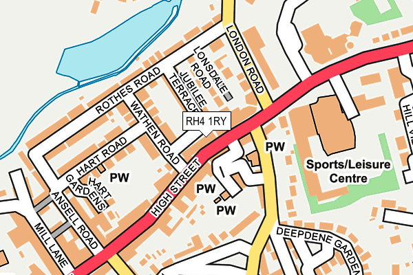
RH4 1RY lies on High Street in Dorking. RH4 1RY is located in the Dorking North electoral ward, within the local authority district of Mole Valley and the English Parliamentary constituency of Mole Valley. The Sub Integrated Care Board (ICB) Location is NHS Surrey Heartlands ICB - 92A and the police force is Surrey. This postcode has been in use since December 1999.


GetTheData
Source: OS OpenMap – Local (Ordnance Survey)
Source: OS VectorMap District (Ordnance Survey)
Licence: Open Government Licence (requires attribution)
| Easting | 516854 |
| Northing | 149682 |
| Latitude | 51.234367 |
| Longitude | -0.327626 |
GetTheData
Source: Open Postcode Geo
Licence: Open Government Licence
| Street | High Street |
| Town/City | Dorking |
| Country | England |
| Postcode District | RH4 |
| ➜ RH4 open data dashboard ➜ See where RH4 is on a map ➜ Where is Dorking? | |
GetTheData
Source: Land Registry Price Paid Data
Licence: Open Government Licence
Elevation or altitude of RH4 1RY as distance above sea level:
| Metres | Feet | |
|---|---|---|
| Elevation | 60m | 197ft |
Elevation is measured from the approximate centre of the postcode, to the nearest point on an OS contour line from OS Terrain 50, which has contour spacing of ten vertical metres.
➜ How high above sea level am I? Find the elevation of your current position using your device's GPS.
GetTheData
Source: Open Postcode Elevation
Licence: Open Government Licence
| Ward | Dorking North |
| Constituency | Mole Valley |
GetTheData
Source: ONS Postcode Database
Licence: Open Government Licence
THE OLD COURT HOUSE, 277, HIGH STREET, DORKING, RH4 1RY 2005 30 JUN £270,000 |
GetTheData
Source: HM Land Registry Price Paid Data
Licence: Contains HM Land Registry data © Crown copyright and database right 2024. This data is licensed under the Open Government Licence v3.0.
| January 2024 | Anti-social behaviour | On or near Shopping Area | 316m |
| December 2023 | Public order | On or near Shopping Area | 316m |
| December 2023 | Shoplifting | On or near Shopping Area | 316m |
| ➜ Get more crime data in our Crime section | |||
GetTheData
Source: data.police.uk
Licence: Open Government Licence
| Moores Road (High Street) | Dorking | 26m |
| Moores Road (High Street) | Dorking | 52m |
| Council Offices (Reigate Road) | Pippbrook | 227m |
| White Horse (High Street) | Dorking | 241m |
| White Horse (High Street) | Dorking | 257m |
| Dorking Deepdene Station | 0.5km |
| Dorking Station | 0.8km |
| Dorking West Station | 0.9km |
GetTheData
Source: NaPTAN
Licence: Open Government Licence
GetTheData
Source: ONS Postcode Database
Licence: Open Government Licence


➜ Get more ratings from the Food Standards Agency
GetTheData
Source: Food Standards Agency
Licence: FSA terms & conditions
| Last Collection | |||
|---|---|---|---|
| Location | Mon-Fri | Sat | Distance |
| Dorking Halls | 17:15 | 13:00 | 135m |
| Dorking Post Office | 18:00 | 12:30 | 215m |
| Cleardene | 17:30 | 12:30 | 401m |
GetTheData
Source: Dracos
Licence: Creative Commons Attribution-ShareAlike
| Facility | Distance |
|---|---|
| Anytime Fitness (Dorking) High Street, Dorking Health and Fitness Gym | 30m |
| Dorking Sports Centre Reigate Road, Dorking Sports Hall, Swimming Pool, Health and Fitness Gym, Studio, Outdoor Tennis Courts | 185m |
| Meadowbank Football Ground Mill Lane, Dorking Artificial Grass Pitch | 350m |
GetTheData
Source: Active Places
Licence: Open Government Licence
| School | Phase of Education | Distance |
|---|---|---|
| The Ashcombe School Ashcombe Road, Dorking, RH4 1LY | Secondary | 505m |
| St Paul's CofE (Aided) Primary School St Paul's Road West, Dorking, RH4 2HS | Primary | 688m |
| Dorking Nursery School West Street, Dorking, RH4 1BY | Nursery | 707m |
GetTheData
Source: Edubase
Licence: Open Government Licence
The below table lists the International Territorial Level (ITL) codes (formerly Nomenclature of Territorial Units for Statistics (NUTS) codes) and Local Administrative Units (LAU) codes for RH4 1RY:
| ITL 1 Code | Name |
|---|---|
| TLJ | South East (England) |
| ITL 2 Code | Name |
| TLJ2 | Surrey, East and West Sussex |
| ITL 3 Code | Name |
| TLJ26 | East Surrey |
| LAU 1 Code | Name |
| E07000210 | Mole Valley |
GetTheData
Source: ONS Postcode Directory
Licence: Open Government Licence
The below table lists the Census Output Area (OA), Lower Layer Super Output Area (LSOA), and Middle Layer Super Output Area (MSOA) for RH4 1RY:
| Code | Name | |
|---|---|---|
| OA | E00155725 | |
| LSOA | E01030532 | Mole Valley 009A |
| MSOA | E02006370 | Mole Valley 009 |
GetTheData
Source: ONS Postcode Directory
Licence: Open Government Licence
| RH4 1RL | High Street | 23m |
| RH4 1AU | Lonsdale Place | 38m |
| RH4 1QX | High Street | 42m |
| RH4 1LE | Jubilee Terrace | 53m |
| RH4 1QT | High Street | 64m |
| RH4 1RE | High Street | 75m |
| RH4 2FQ | Brunswick Walk | 76m |
| RH4 1JP | Lonsdale Road | 80m |
| RH4 1JU | Wathen Road | 84m |
| RH4 1JY | Wathen Road | 85m |
GetTheData
Source: Open Postcode Geo; Land Registry Price Paid Data
Licence: Open Government Licence