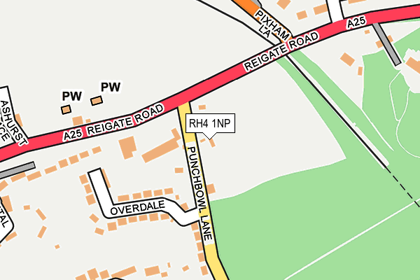
RH4 1NP is located in the Dorking South electoral ward, within the local authority district of Mole Valley and the English Parliamentary constituency of Mole Valley. The Sub Integrated Care Board (ICB) Location is NHS Surrey Heartlands ICB - 92A and the police force is Surrey. This postcode has been in use since March 1983.


GetTheData
Source: OS OpenMap – Local (Ordnance Survey)
Source: OS VectorMap District (Ordnance Survey)
Licence: Open Government Licence (requires attribution)
| Easting | 517626 |
| Northing | 149962 |
| Latitude | 51.236723 |
| Longitude | -0.316458 |
GetTheData
Source: Open Postcode Geo
Licence: Open Government Licence
| Country | England |
| Postcode District | RH4 |
| ➜ RH4 open data dashboard ➜ See where RH4 is on a map ➜ Where is Dorking? | |
GetTheData
Source: Land Registry Price Paid Data
Licence: Open Government Licence
Elevation or altitude of RH4 1NP as distance above sea level:
| Metres | Feet | |
|---|---|---|
| Elevation | 60m | 197ft |
Elevation is measured from the approximate centre of the postcode, to the nearest point on an OS contour line from OS Terrain 50, which has contour spacing of ten vertical metres.
➜ How high above sea level am I? Find the elevation of your current position using your device's GPS.
GetTheData
Source: Open Postcode Elevation
Licence: Open Government Licence
| Ward | Dorking South |
| Constituency | Mole Valley |
GetTheData
Source: ONS Postcode Database
Licence: Open Government Licence
| June 2022 | Violence and sexual offences | On or near Reigate Road | 123m |
| June 2022 | Vehicle crime | On or near Reigate Road | 123m |
| June 2022 | Criminal damage and arson | On or near Overdale | 162m |
| ➜ Get more crime data in our Crime section | |||
GetTheData
Source: data.police.uk
Licence: Open Government Licence
| Pixham Lane (Reigate Road) | Dorking | 64m |
| Pixham Lane (Reigate Road) | Dorking | 81m |
| Cemetery (Reigate Road) | Dorking | 117m |
| Cemetery (Reigate Road) | Dorking | 175m |
| Chester Close (Pixham Lane) | Pixham | 210m |
| Dorking Deepdene Station | 0.6km |
| Dorking Station | 0.7km |
| Dorking West Station | 1.6km |
GetTheData
Source: NaPTAN
Licence: Open Government Licence
GetTheData
Source: ONS Postcode Database
Licence: Open Government Licence


➜ Get more ratings from the Food Standards Agency
GetTheData
Source: Food Standards Agency
Licence: FSA terms & conditions
| Last Collection | |||
|---|---|---|---|
| Location | Mon-Fri | Sat | Distance |
| Pixham Tso | 17:15 | 12:15 | 299m |
| Deepdene Vale | 17:15 | 12:00 | 324m |
| Fairfield Drive | 17:30 | 12:15 | 612m |
GetTheData
Source: Dracos
Licence: Creative Commons Attribution-ShareAlike
| Facility | Distance |
|---|---|
| Pixham Sports Ground Pixham Lane, Dorking Grass Pitches | 559m |
| Dorking Sports Centre Reigate Road, Dorking Sports Hall, Swimming Pool, Health and Fitness Gym, Studio, Outdoor Tennis Courts | 641m |
| Betchworth Park Golf Club Reigate Road, Dorking Golf | 775m |
GetTheData
Source: Active Places
Licence: Open Government Licence
| School | Phase of Education | Distance |
|---|---|---|
| The Ashcombe School Ashcombe Road, Dorking, RH4 1LY | Secondary | 942m |
| St Paul's CofE (Aided) Primary School St Paul's Road West, Dorking, RH4 2HS | Primary | 1.3km |
| Dorking Nursery School West Street, Dorking, RH4 1BY | Nursery | 1.5km |
GetTheData
Source: Edubase
Licence: Open Government Licence
The below table lists the International Territorial Level (ITL) codes (formerly Nomenclature of Territorial Units for Statistics (NUTS) codes) and Local Administrative Units (LAU) codes for RH4 1NP:
| ITL 1 Code | Name |
|---|---|
| TLJ | South East (England) |
| ITL 2 Code | Name |
| TLJ2 | Surrey, East and West Sussex |
| ITL 3 Code | Name |
| TLJ26 | East Surrey |
| LAU 1 Code | Name |
| E07000210 | Mole Valley |
GetTheData
Source: ONS Postcode Directory
Licence: Open Government Licence
The below table lists the Census Output Area (OA), Lower Layer Super Output Area (LSOA), and Middle Layer Super Output Area (MSOA) for RH4 1NP:
| Code | Name | |
|---|---|---|
| OA | E00155739 | |
| LSOA | E01030537 | Mole Valley 010C |
| MSOA | E02006371 | Mole Valley 010 |
GetTheData
Source: ONS Postcode Directory
Licence: Open Government Licence
| RH5 4BP | Punchbowl Lane | 121m |
| RH5 4BT | Overdale | 156m |
| RH4 1QB | Reigate Road | 182m |
| RH5 4BW | Punchbowl Lane | 204m |
| RH5 4BS | Overdale | 205m |
| RH4 1BF | Betchworth Place | 231m |
| RH4 1PT | Pixham Lane | 248m |
| RH4 1PE | Redcote Place | 248m |
| RH4 1PA | Reigate Road | 265m |
| RH4 1QY | Ashurst Place | 271m |
GetTheData
Source: Open Postcode Geo; Land Registry Price Paid Data
Licence: Open Government Licence